Case study:Rottal Burn
Project overview
| Status | Complete |
|---|---|
| Project web site | http://www.erft.org.uk/index.php/articles/articles/271-restoration-of-the-rottal-burn-glen-clova |
| Themes | Fisheries, Habitat and biodiversity |
| Country | Scotland |
| Main contact forename | Nick |
| Main contact surname | Elbourne |
| Main contact user ID | |
| Contact organisation | Esk Rivers and Fisheries Trust |
| Contact organisation web site | http://www.erft.org.uk/ |
| Partner organisations | |
| Parent multi-site project | |
| This is a parent project encompassing the following projects |
No |
Project summary
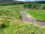
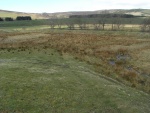
The reach of the Rottal burn between Rottal Lodge and its confluence with the South Esk has historically been realigned and straightened since the 1830’s. In 2003, just prior to the Water Framework Directive coming into force, the stretch was dredged out destroying the existing habitat.
The works carried out in 2012 aimed to restore natural river processes and in stream and riparian habitat, specifically for Atlantic salmon and freshwater pearl mussel alongside other fish species. It is relevant to note that the freshwater pearl mussel is dependent on juvenile salmon populations for the completion of its life cycle.
Objectives of the project included: • Restoration of the canalised water course as far as possible to its natural course (to be extended from 650m to 1,100m) • Reconnection of the Rottal Burn with its flood plain • Creation of a diverse riparian and aquatic habitat including the incorporation of the existing wetland habitat into the final restoration design • Reduction in the unnaturally high sediment loading during high flow events which is then deposited in the lower reaches • A return to a more natural flow regime • Attenuation of flood peaks • Visual enhancement of the area • Restoration of sustainable, functional populations of multi-sea-winter salmon and trout and of freshwater pearl mussels • The possibility of transferring freshwater pearl mussels into the burn will be investigated • Development a demonstration site available for future research • Provision of restoration experience which would be transferable to other similar situations within the catchment
Construction works were designed to create the restored channel without any import or export of materials, by using existing gravel embankments to provide any material needed. Large woody debris (trees with rootballs) which were sourced from the local estate, were used to reinforce possible areas of adjustment. A two-phase construction programme was used; Firstly the new channel was constructed and vegetation growth allowed to take hold. Following this flow was diverted into the new channel. Challenges at the site included the remote location, adverse weather conditions and the presence of overhead services. A number of sediment bar features have already formed, significantly improving the habitat, which is confirmed by the presence of salmon spawning in the new channel.
The primary funder for the project was the Scottish Environment Protection Agency (SEPA). If you are interested in applying for funding to deliver other projects in Scotland, visit SEPA's Water Environment Fund webpage (http://www.sepa.org.uk/water/water_environment_fund.aspx).
Monitoring surveys and results
Lessons learnt
Image gallery
|
Catchment and subcatchmentSelect a catchment/subcatchment
Catchment
Subcatchment
Other case studies in this subcatchment: South Esk restoration
Site
Project background
Cost for project phases
Reasons for river restoration
Measures
MonitoringHydromorphological quality elements
Biological quality elements
Physico-chemical quality elements
Any other monitoring, e.g. social, economic
Monitoring documents
Additional documents and videos
Additional links and references
Supplementary InformationEdit Supplementary Information
| ||||||||||||||||||||||||||||||||||||||||||||||||||||||||||||||||||||||||||||||||||||||||||||||||||||||||||||||||||||||||||||||||||||||||||||||||||||||||||||||||||||||||||||||||||||||||||||||||||||||||||||


