Case study:Restoration of the previous riverbed of the Dadon

From RESTORE
Revision as of 10:25, 16 January 2014 by Anna.polazzo (talk | contribs)
Jump to navigation Jump to search
4.00
(one vote)


To discuss or comment on this case study, please use the discussion page.


Location: 45° 51' 4.09" N, 5° 57' 51.33" E
Loading map...
Left click to look around in the map, and use the wheel of your mouse to zoom in and out.


Project overview

Edit project overview
Status Complete
Project web site
Themes Habitat and biodiversity, Hydromorphology, Monitoring, Water quality
Country France
Main contact forename Regis
Main contact surname Talguen
Main contact user ID
Contact organisation Syndicat mixte interdépartemental d’aménagement du Chéran
Contact organisation web site
Partner organisations
Parent multi-site project
This is a parent project
encompassing the following
projects
No
This case study hasn’t got a picture, you can add one by editing the project overview.

Project summary

Edit project overview to modify the project summary.


The Dadon is one of the last free flowing tributaries of the Lower Cheran. The Dadon watershed is concerned with two areas of industrial activities ( Alby -sur- Cheran and Rumilly) on its downstream sector, the rest of the watershed is occupied by farm land (55 % of the area ) and forest (13 % ). The main pressure factors on the Dadon are the following: • accidental pollutant releases in the industrial areas; • organic pollution from farms and food processing factories; • over-widening, straightening and embankment of its course, causing habitat depletion and lowering of the water table in its downstream stretch. These factors greatly reduced the initially existing connections between the Dadon and the Cheran, thereby significantly lowering the ecological value of this naturally rich confluence area. The main goals of the project were to restore the original riverbed of the Dadon, and to diversify flows and habitats, especially increasing water depths at low water flows. It was also aimed to stabilize banks and restore riparian vegetation. The works consisted of three steps: • 2004 (involved length 350 m): rock sills and groynes to promote diversification of habitats; construction of vegetated log cribwalls, associated with geotextile to ensure bank stabilization (the restoration of a natural lateral dynamics was not part of project goals); creation of a narrower and meandering river bed; • 2006 (involved length 475 m, downstream the previous stretch): the stream is returned in its original sinuous bed, as it was before the 90’s; • 2009 (involved length 175 m, further downstream): introduction of blocks, stone sills, wooden groynes. The works were carried out within the framework of the river contract brought by the Syndicat Mixte Interdépartemental d’Aménagement du Chéran (SMIAC). The local angling association strongly supported the action.

Monitoring surveys and results

Edit project overview to modify the Monitoring survey and results.


The first results of the post-work monitoring are in overall terms encouraging. An improvement of the quality of habitats and of the macro-benthic population was demonstrated. The fish population shows some improvement, although the goal to restore a structured trout population is not yet met. From a social point of view, the operation was very well accepted.

Lessons learnt

This case study hasn’t got any lessons learnt, you can add some by editing the project overview.


Image gallery


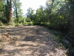
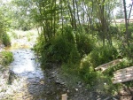
The Dadon riverbed, before restoration, in June 2004.
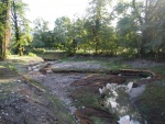
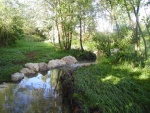
The riverbed after restoration, in August 2004: it recovered its meandering channel.
The rectifed river channel, before restoration, in June 2004.
The The meandering riverbed after restoration, in August 2
ShowHideAdditionalImage.png


Catchment and subcatchment

Catchment

River basin district Rhône - Méditerranée
River basin Haute-Savoie

Subcatchment

River name Dadon
Area category 100 - 1000 km²
Area (km2)
Maximum altitude category 500 - 1000 m
Maximum altitude (m)
Dominant geology Siliceous
Ecoregion Western Highlands
Dominant land cover
Waterbody ID


Site

Name Dadon
WFD water body codes FRDR11706
WFD (national) typology
WFD water body name
Pre-project morphology Single channel, Straight
Reference morphology Single channel, Sinuous
Desired post project morphology
Heavily modified water body true
National/international site designation
Local/regional site designations
Protected species present
Invasive species present
Species of interest
Dominant hydrology Quick run-off
Dominant substrate Bedrock, Cobble, Gravel
River corridor land use Extensive agriculture, Grassland
Average bankfull channel width category 5 - 10 m
Average bankfull channel width (m)
Average bankfull channel depth category 2 - 5 m
Average bankfull channel depth (m)
Mean discharge category
Mean annual discharge (m3/s) 0.90.9 m³/s <br />900 l/s <br />
Average channel gradient category
Average channel gradient 0.25
Average unit stream power (W/m2)


Project background

Reach length directly affected (m) 1000 m1 km <br />100,000 cm <br />
Project started 2004/05/01
Works started 2004/05/01
Works completed 2009/09/01
Project completed
Total cost category
Total cost (k€) 195195 k€ <br />195,000 € <br />
Benefit to cost ratio
Funding sources Water Agency, SMIAC, Councils of Savoie and Haute-Savoie

Cost for project phases

Phase cost category cost exact (k€) Lead organisation Contact forename Contact surname
Investigation and design 1 - 10 k€ Water Agency
Stakeholder engagement and communication Water Agency
Works and works supervision 182.62182.62 k€ <br />182,620 € <br /> Water Agency
Post-project management and maintenance 44 k€ <br />4,000 € <br /> Water Agency
Monitoring Water Agency


Reasons for river restoration

Mitigation of a pressure Riparian development
Hydromorphology Width & depth variation, Flow velocities, Quantity & dynamics of flow, Channel pattern/planform, Continuity for organisms
Biology Fish: Species composition, Fish: Abundance
Physico-chemical
Other reasons for the project Bank erosion, Landscape enhancement


Measures

Structural measures
Bank/bed modifications Implementation of rip rap, Habitat diversification, Implementation of vegetated boxes, Depth variation, Restoration of original bed
Floodplain / River corridor
Planform / Channel pattern Creation of meanders, Creation of sinuosity
Other
Non-structural measures
Management interventions
Social measures (incl. engagement)
Other


Monitoring

Hydromorphological quality elements

Element When monitored Type of monitoring Control site used Result
Before measures After measures Qualitative Quantitative
Width & depth variation Yes Yes Yes Improvement
Channel pattern/planform Yes Yes Yes Improvement

Biological quality elements

Element When monitored Type of monitoring Control site used Result
Before measures After measures Qualitative Quantitative
Fish: Species composition Yes Yes Yes Improvement
Fish: Abundance Yes Yes Yes Improvement

Physico-chemical quality elements

Element When monitored Type of monitoring Control site used Result
Before measures After measures Qualitative Quantitative

Any other monitoring, e.g. social, economic

Element When monitored Type of monitoring Control site used Result
Before measures After measures Qualitative Quantitative


Monitoring documents


Additional documents and videos


Additional links and references

Link Description

Supplementary Information

Edit Supplementary Information