Case study:River Fugla
Project overview
| Status | Complete |
|---|---|
| Project web site | |
| Themes | Habitat and biodiversity, Monitoring |
| Country | Norway |
| Main contact forename | Arne Jørgen |
| Main contact surname | Kjøsnes |
| Main contact user ID | User:Kasvio |
| Contact organisation | NVE (Norwegian Water Resources and Energy Directorate) |
| Contact organisation web site | http://www.niva.no |
| Partner organisations | |
| Parent multi-site project | |
| This is a parent project encompassing the following projects |
No |
Project summary
The river Fugla is a small river in Hell in Stjoerdal community in the middle part of Norway. River is situated next to the river Stjørdalselva. This is in an area susceptible to slides and the river has been cutting increasingly deeper into the potential unstable sediments.
Quick clay is a type of marine clay prone to sudden loss of strength when disturbed. After failure the clay may become liquid, and this could lead to big landslides. Primarily found in the upper region of the Northern Hemisphere. Quick clay slides occur without warning and may wipe out large areas often causing loss of life and substantial material damage. Landslides can be triggered by high rivers that erode and saturate clay slopes, by melt water and rain that destabilize a deposit or by human activity such as fillings, excavations etc.. In populated areas with high risk of landslide hazard, improvements as raising the river bottom is used to stop erosion. In many rivers and brooks large stretches of the river bed might be raised by several meters and both the river bed and banks will be plastered with erosion-proof rocks.
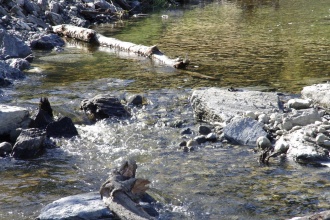
NVE secured this river for further erosion and the work was conducted with the use of erosion-proof rocks both in the river bed and banks for a total distance of about 600 meters. Prior to the mitigating work the water quality was poor and the river was often colored grey due to erosion. Also logs, roots etc were placed in the brook and spawning gravel in to the rapid areas.
The construction work protects the area from the slides. At the same time it can ruin habitats for anadromous fish and aquatic invertebrates. To restore the river and recreate suitable habitats for sea trout and salmon, some simple mitigating measures were done. Building small weirs to create deeper ponds, adding spawning gravel, roots with rootwad, and the use of logs and large woody debris, made the river more suitable for aquatic organisms. Mitigating measures were set up over a distance of about 250 meters of the river. With the measures done the river now lookes more natural.
Monitoring surveys and results
The brook is now more suited for fish because the water quality is better. One month after the restoration work numerous sea trout individuals were observed spawning in the River Fugla.
Lessons learnt
Image gallery
|
Catchment and subcatchment
Site
Project background
Cost for project phases
Reasons for river restoration
Measures
MonitoringHydromorphological quality elements
Biological quality elements
Physico-chemical quality elements
Any other monitoring, e.g. social, economic
Monitoring documents
Additional documents and videos
Additional links and references
Supplementary InformationEdit Supplementary Information
| |||||||||||||||||||||||||||||||||||||||||||||||||||||||||||||||||||||||||||||||||||||||||||||||||||||||||||||||||||||||||||||||||||||||||||||||||||||||||||||||||||||||||||||||


