Case study:Salzano wetland and Marzenego river restoration project

From RESTORE
Revision as of 11:06, 24 September 2013 by SFW Rob (talk | contribs)
Jump to navigation Jump to search
0.00
(0 votes)


To discuss or comment on this case study, please use the discussion page.


Location: 45° 32' 2.12" N, 12° 7' 52.90" E
Loading map...
Left click to look around in the map, and use the wheel of your mouse to zoom in and out.


Project overview

Edit project overview
Status Complete
Project web site
Themes Flood risk management, Habitat and biodiversity, Land use management - forestry, Monitoring, Social benefits, Water quality
Country Italy
Main contact forename Paolo
Main contact surname Cornelio
Main contact user ID
Contact organisation Consorzio di Bonifica Acque Risorgive
Contact organisation web site http://www.acquerisorgive.it/
Partner organisations
Parent multi-site project
This is a parent project
encompassing the following
projects
No
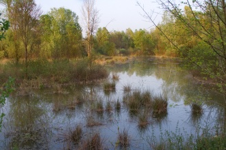
Salzano wetland after restoration

Project summary

Edit project overview to modify the project summary.


In order to reduce eutrophication problems that severely impair the quality of the Venice lagoon waters, the local government (the Veneto Region Authority), more than a decade ago,established a series of targets for the the reduction of nutrients that flow into the lagoon. As a detailed example, The “Salzano wetland” restoration was completed by the consortium which was, until the mid-1980s, subject to mining of clay. Since this period this 60 ha site has gradually been restored. Today this site is characterized by a mosaic of habitats of different spatial extent. The main actions of the project were: a) to create a system of new banks around a dry and with low ecological value portion (20 ha wide) of the extent wetland, and later to connect this area with the adjacent watercourse using gates to manage flows; b) reshaping the net of canals, ponds and pools inside this area to find the optimal residual time of the water to assure an efficient nutrient reduction; c) re-establish rare and endangered aquatic vegetation types (Carex elata, Cladium mariscus, Allium angulosum, Cirsium canum, Senecio paludosus, Typha laxmannii, Iris pseudacorus and Nuphar luteum) and monitor their development; d) create a new net of small channels to connect this restored wetland to the other portions; e) create a net of path and observation structures accessible to the public for recreation, educational and technical-scientific purposes.

Monitoring surveys and results

This case study hasn’t got any Monitoring survey and results, you can add some by editing the project overview.

Lessons learnt

This case study hasn’t got any lessons learnt, you can add some by editing the project overview.


Image gallery


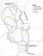
Map of Salzano wetland
View of Salzano wetland after restoration
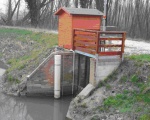
Inlet point
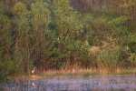
Salzano.jpg
ShowHideAdditionalImage.png


Catchment and subcatchment

Catchment

River basin district Alpi Orientali
River basin Bacino scolante della Laguna di Venezia

Subcatchment

River name Bacino scolante della Laguna di Venezia
Area category 1000 - 10000 km²
Area (km2) 2,0382,038 km² <br />203,800 ha <br />
Maximum altitude category 100 - 200 m
Maximum altitude (m)
Dominant geology
Ecoregion Italy and Corsica
Dominant land cover Intensive agriculture (arable)
Waterbody ID


Other case studies in this subcatchment: Pagana canal restoration project, Rio San Martino and Piovega di Scandolara restoration project, Rio Sant'Ambrogio restoration project, Scolo Desolino restoration project, Zero river restoration project


Site

Name Salzano wetland and Marzenego river
WFD water body codes 666_10
WFD (national) typology
WFD water body name MARZENEGO - OSELLINO (DIRAM.)
Pre-project morphology Artificial channel
Reference morphology Low gradient passively meandering
Desired post project morphology
Heavily modified water body Yes
National/international site designation Italy - Siti di Importanza Comunitaria
Local/regional site designations SIC IT3250008
Protected species present Yes
Invasive species present Yes
Species of interest Carex elata, Cladium mariscus, Allium angulosum, Cirsium canum, Senecio paludosus, Typha laxmannii, Iris pseudacorus and Nuphar luteum
Dominant hydrology Artificially regulated
Dominant substrate
River corridor land use Intensive agriculture (arable)
Average bankfull channel width category 10 - 50 m
Average bankfull channel width (m)
Average bankfull channel depth category 0.5 - 2 m
Average bankfull channel depth (m)
Mean discharge category 1 - 10 m³/s
Mean annual discharge (m3/s)
Average channel gradient category 0.001 - 0.01
Average channel gradient
Average unit stream power (W/m2)


Project background

Reach length directly affected (m)
Project started 2007
Works started
Works completed
Project completed 2009/10/01
Total cost category 1000 - 5000 k€
Total cost (k€) 2,7142,714 k€ <br />2,714,000 € <br />
Benefit to cost ratio
Funding sources Veneto Region - “Piano per la prevenzione dell’inquinamento ed il risanamento delle acque del bacino idrografico immediatamente sversante in Laguna – Piano Direttore 2000”

Cost for project phases

Phase cost category cost exact (k€) Lead organisation Contact forename Contact surname
Investigation and design
Stakeholder engagement and communication
Works and works supervision
Post-project management and maintenance
Monitoring


Reasons for river restoration

Mitigation of a pressure Nutrient removal to reduce eutrophication, reduce flood risk, increase lost biodiversity
Hydromorphology Reconnect river to an out-flow wetland and create a more natural morphology inseide the wetland
Biology Increase ecological status of Macrophytes
Physico-chemical Reduce Nitrogen, Phosphorous and Organic pollution
Other reasons for the project Increase fruition and biodiversity in general


Measures

Structural measures
Bank/bed modifications Reshaping the net of canals, ponds and pools inside the wetland
Floodplain / River corridor Hydraulic connection between the river and an outflow wetland
Planform / Channel pattern
Other re-establish rare and endangered aquatic vegetation types
Non-structural measures
Management interventions
Social measures (incl. engagement) create a net of path and observation structures accessible to the public for recreation, educational and technical-scientific purposes
Other


Monitoring

Hydromorphological quality elements

Element When monitored Type of monitoring Control site used Result
Before measures After measures Qualitative Quantitative

Biological quality elements

Element When monitored Type of monitoring Control site used Result
Before measures After measures Qualitative Quantitative

Physico-chemical quality elements

Element When monitored Type of monitoring Control site used Result
Before measures After measures Qualitative Quantitative
Nutrient concentrations No Yes No Yes No

Any other monitoring, e.g. social, economic

Element When monitored Type of monitoring Control site used Result
Before measures After measures Qualitative Quantitative


Monitoring documents


Additional documents and videos


Additional links and references

Link Description
http://http://www.acquerisorgive.it/page.asp?m=18 A website section dedicated to river restoration projects, studies and monitoring results by Consorzio Acque Risorgive

Supplementary Information

Edit Supplementary Information


Image gallery


Map of Salzano wetland
View of Salzano wetland after restoration
Inlet point
Salzano.jpg