Case study:Mains of Dyce
Project overview
| Status | Complete |
|---|---|
| Project web site | |
| Themes | Hydromorphology |
| Country | Scotland |
| Main contact forename | Hamish |
| Main contact surname | Moir |
| Main contact user ID | |
| Contact organisation | cbec eco engineering |
| Contact organisation web site | http://www.cbecoeng.co.uk/ |
| Partner organisations | |
| Parent multi-site project | |
| This is a parent project encompassing the following projects |
No |
Project summary
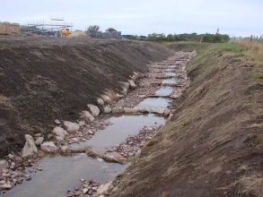
SEPA required the culverted channel to be “re-daylighted”. The overarching aim was to restore catchment scale processes as much as possible, taking a long term sustainable rather than quick fix approach.
Constraints on the scale of restoration included: large housing development close by, lack of a catchment scale management plan, lack of funding and knowledge.
Housing developer initially carried out works, resulting in an unstable channel design. Two one in ten year flooding events which occurred in 2009 caused severe incision of the channel up to 2.7 meters, which in total was estimated to have removed 539m3 of material.
cbec eco engineering was subsequently contracted to re-design the channel. Step-pool design was chosen based on modelling. Works included bed and bank profiling, and step construction from boulders and smaller cobbles/gravels.
Monitoring has indicated that channel design is stable.
Monitoring surveys and results
Lessons learnt
Catchment and subcatchment
Edit the catchment and subcatchment details
(affects all case studies in this subcatchment)
Catchment
| River basin district | North East Scotland |
|---|---|
| River basin | Don |
Subcatchment
| River name | Don |
|---|---|
| Area category | |
| Area (km2) | |
| Maximum altitude category | |
| Maximum altitude (m) | |
| Dominant geology | |
| Ecoregion | |
| Dominant land cover | Intensive agriculture (arable), Improved/semi-improved grassland/pasture, Broadleaf/mixed woodland (semi natural) |
| Waterbody ID |
Site
| Name | Mains of Dyce |
|---|---|
| WFD water body codes | |
| WFD (national) typology | |
| WFD water body name | |
| Pre-project morphology | Closed culvert |
| Reference morphology | Open culvert |
| Desired post project morphology | |
| Heavily modified water body | No |
| National/international site designation | |
| Local/regional site designations | |
| Protected species present | No |
| Invasive species present | No |
| Species of interest | |
| Dominant hydrology | |
| Dominant substrate | |
| River corridor land use | |
| Average bankfull channel width category | |
| Average bankfull channel width (m) | |
| Average bankfull channel depth category | |
| Average bankfull channel depth (m) | |
| Mean discharge category | |
| Mean annual discharge (m3/s) | |
| Average channel gradient category | |
| Average channel gradient | |
| Average unit stream power (W/m2) |
Project background
| Reach length directly affected (m) | 165165 m <br />0.165 km <br />16,500 cm <br /> |
|---|---|
| Project started | 2009/08/01 |
| Works started | |
| Works completed | |
| Project completed | 2010/09/01 |
| Total cost category | |
| Total cost (k€) | |
| Benefit to cost ratio | |
| Funding sources |
Cost for project phases
| Phase | cost category | cost exact (k€) | Lead organisation | Contact forename | Contact surname |
|---|---|---|---|---|---|
| Investigation and design | |||||
| Stakeholder engagement and communication | |||||
| Works and works supervision | |||||
| Post-project management and maintenance | |||||
| Monitoring |
Reasons for river restoration
| Mitigation of a pressure | |
|---|---|
| Hydromorphology | |
| Biology | |
| Physico-chemical | |
| Other reasons for the project |
Measures
Structural measures
| |
|---|---|
| Bank/bed modifications | |
| Floodplain / River corridor | |
| Planform / Channel pattern | |
| Other | |
Non-structural measures
| |
| Management interventions | |
| Social measures (incl. engagement) | |
| Other | |
Monitoring
Hydromorphological quality elements
| Element | When monitored | Type of monitoring | Control site used | Result | ||
|---|---|---|---|---|---|---|
| Before measures | After measures | Qualitative | Quantitative | |||
Biological quality elements
| Element | When monitored | Type of monitoring | Control site used | Result | ||
|---|---|---|---|---|---|---|
| Before measures | After measures | Qualitative | Quantitative | |||
Physico-chemical quality elements
| Element | When monitored | Type of monitoring | Control site used | Result | ||
|---|---|---|---|---|---|---|
| Before measures | After measures | Qualitative | Quantitative | |||
Any other monitoring, e.g. social, economic
| Element | When monitored | Type of monitoring | Control site used | Result | ||
|---|---|---|---|---|---|---|
| Before measures | After measures | Qualitative | Quantitative | |||
Monitoring documents
Image gallery
Additional documents and videos
Additional links and references
| Link | Description |
|---|
Supplementary Information
Edit Supplementary Information

