Case study:Environmental design Mandalsvassdraget

From RESTORE
Revision as of 11:46, 9 January 2020 by NINA (talk | contribs)
Jump to navigation Jump to search

This case study is pending approval by a RiverWiki administrator.

Approve case study


0.00
(0 votes)


To discuss or comment on this case study, please use the discussion page.


Location: 58° 14' 40.24" N, 7° 30' 50.40" E
Loading map...
Left click to look around in the map, and use the wheel of your mouse to zoom in and out.


Project overview

Edit project overview
Status Complete
Project web site
Themes Fisheries, Hydropower, Hydromorphology
Country Norway
Main contact forename Aleksander
Main contact surname Andersen
Main contact user ID
Contact organisation Agder Energi
Contact organisation web site http://https://www.ae.no/
Partner organisations NINA, Sintef, Norce Research
Parent multi-site project
This is a parent project
encompassing the following
projects
No
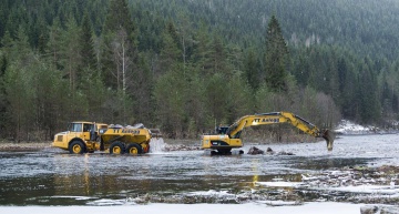
Removal of weirs in the Mandalselva river in connection to efforts to make earlier unproductive sones accessible as spawning and aufwuchs areas for salmon. Foto: Agder Energi

Project summary

Edit project overview to modify the project summary.


Mandalselva is regulated for hydropower production since 1947 and this has impacted the conditions for Atlantic salmon in this river. The project "Miljødesign Mandalselva" used the concept of Environmental Design as described in the "Handbook for environmental design in regulated salmon river (Forseth and Harby 2013) and was accompanied by thorough research efforts in order to study which measures would be suitable to improve the conditions for salmon and at the same time to take into account hydropower production. This researcj was led by the Norwegian Institute for Nature Research (NINA) and conducted in cooperation with SINTEF Energy, Norce Research and Skandinavisk Naturovervåking. It included i.a. a trade-off analysis between the production of Atlantic salmon and the production of hydropower by examining the use of several physical mitigation measures and changes in release of water. Local stakeholders and public natural resource management were involved by means of a counceling group. As a result, nine weirs in the river were removed and further habitat improving measures were put in place (e.g. installation of gravel habitat).

Monitoring surveys and results

Edit project overview to modify the Monitoring survey and results.


They are expected to be published soon.

Lessons learnt

Edit project overview to modify the lessons learnt.


to come soon...


Image gallery


ShowHideAdditionalImage.png


Catchment and subcatchment


Site

Name
WFD water body codes
WFD (national) typology
WFD water body name Mandalselva
Pre-project morphology
Reference morphology
Desired post project morphology
Heavily modified water body No
National/international site designation
Local/regional site designations
Protected species present Yes
Invasive species present No
Species of interest Atlantic salmon (Salmo salar)
Dominant hydrology
Dominant substrate
River corridor land use Intensive agriculture (arable), Rough unimproved grassland/pasture
Average bankfull channel width category
Average bankfull channel width (m)
Average bankfull channel depth category
Average bankfull channel depth (m)
Mean discharge category
Mean annual discharge (m3/s) 8888 m³/s <br />88,000 l/s <br />
Average channel gradient category
Average channel gradient
Average unit stream power (W/m2)


Project background

Reach length directly affected (m)
Project started 01.10.2014
Works started
Works completed 2018/03/01
Project completed
Total cost category 100 - 500 k€
Total cost (k€) 394394 k€ <br />394,000 € <br />
Benefit to cost ratio
Funding sources Agder Energi

Cost for project phases

Phase cost category cost exact (k€) Lead organisation Contact forename Contact surname
Investigation and design
Stakeholder engagement and communication
Works and works supervision
Post-project management and maintenance
Monitoring


Reasons for river restoration

Mitigation of a pressure
Hydromorphology
Biology
Physico-chemical
Other reasons for the project


Measures

Structural measures
Bank/bed modifications
Floodplain / River corridor
Planform / Channel pattern
Other
Non-structural measures
Management interventions
Social measures (incl. engagement)
Other


Monitoring

Hydromorphological quality elements

Element When monitored Type of monitoring Control site used Result
Before measures After measures Qualitative Quantitative

Biological quality elements

Element When monitored Type of monitoring Control site used Result
Before measures After measures Qualitative Quantitative

Physico-chemical quality elements

Element When monitored Type of monitoring Control site used Result
Before measures After measures Qualitative Quantitative

Any other monitoring, e.g. social, economic

Element When monitored Type of monitoring Control site used Result
Before measures After measures Qualitative Quantitative


Monitoring documents


Additional documents and videos


Additional links and references

Link Description

Supplementary Information

Edit Supplementary Information