Case study:Beekherstel Beekloop BmN

From RESTORE
Revision as of 13:34, 30 June 2019 by MaritJob (talk | contribs)
Jump to navigation Jump to search

This case study is pending approval by a RiverWiki administrator.

Approve case study


0.00
(0 votes)


To discuss or comment on this case study, please use the discussion page.


Location: 51° 17' 58.84" N, 5° 23' 38.22" E
Loading map...
Left click to look around in the map, and use the wheel of your mouse to zoom in and out.


Project overview

Edit project overview
Status Complete
Project web site
Themes Environmental flows and water resources, Flood risk management, Habitat and biodiversity, Hydromorphology, Water quality
Country Netherlands
Main contact forename Ineke
Main contact surname Barten
Main contact user ID
Contact organisation STOWA
Contact organisation web site http://https://www.stowa.nl/contact
Partner organisations
Parent multi-site project

Case_study:Beekherstel Beekloop

This is a parent project
encompassing the following
projects
No
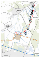
Bestaande situatie (rode lijn betreft het projectgebied, met zwart is aangegeven waar werkzaamheden zijn gepland), bron: http://edepot.wur.nl/396172

Project summary

Edit project overview to modify the project summary.


De Beekloop is voor het grootste deel gegraven door de mens en ontspringt in de bossen tussen Aalst en Hezen en komt uit in de Kleine Dommel ter hoogte van natuurgebied Hulsterbroek. De waterloop ligt bij de overgang van het Kempisch plateau in België tot een lager gelegen gebied in Noord-Brabant, wat resulteert in een relatief groot bodemverhang. De beekloop is betrokken geweest bij vele beekherstel projecten tussen 2010 en 2015, waarbij sommige projecten geclassificeerd kunnen worden als traditioneel beekherstel (TB) en sommige projecten met de focus op Bouwen met Natuur (BmN).

Een van de belangrijkste bouwen met Natuur werkzaamheden die hier zijn uitgevoerd, is het storten van dood hout. Daarnaast is ook specifieke flora geplaatst om de stroming te verbeteren.

Monitoring surveys and results

Edit project overview to modify the Monitoring survey and results.


Behalve de gebruikelijke hydrologische, biologische en fysisch-chemische kwaliteit elementen, zijn er ook chemische metingen gedaan. De beek was voor de werkzaamheden erg vervuild, daardoor is er een zware metalen onderzoek gedaan, microverontreinigingen en bestrijdingsmiddelen zijn gemonitord.

Lessons learnt

This case study hasn’t got any lessons learnt, you can add some by editing the project overview.


Image gallery


ShowHideAdditionalImage.png


Catchment and subcatchment

Catchment

River basin district Meuse
River basin Maas

Subcatchment

River name Dommel
Area category 1000 - 10000 km²
Area (km2) 18001,800 km² <br />180,000 ha <br />
Maximum altitude category Less than 100 m
Maximum altitude (m) 7777 m <br />0.077 km <br />7,700 cm <br />
Dominant geology Siliceous
Ecoregion Western Plains
Dominant land cover Grassland, Intensive agriculture (arable), Broadleaf/mixed woodland (semi natural), Moorland/heathland, Urban
Waterbody ID NL_99_6_BO_BE_2


Other case studies in this subcatchment: Beekherstel Keersop, Beekherstel Reusel Baarschot-Diessen, Boven-Dommel, Buulder Aa, Grote Aa, Herinrichting beekdal Tongelreep, Kleine Aa, traject Smalwater Noord, Kleine Beerze


Site

Name Beekloop
WFD water body codes NL27_BO_3_2
WFD (national) typology R4
WFD water body name
Pre-project morphology Sterk veranderd
Reference morphology R4
Desired post project morphology
Heavily modified water body Yes
National/international site designation Netherlands - Natuurbeschermingswet
Local/regional site designations
Protected species present No
Invasive species present No
Species of interest
Dominant hydrology Langzaamstromende Bovenloop
Dominant substrate Zand
River corridor land use Landbouw/natuur
Average bankfull channel width category 5 - 10 m
Average bankfull channel width (m)
Average bankfull channel depth category
Average bankfull channel depth (m) 0.50.5 m <br />5.0e-4 km <br />50 cm <br />
Mean discharge category
Mean annual discharge (m3/s) 0.30.3 m³/s <br />300 l/s <br />
Average channel gradient category
Average channel gradient
Average unit stream power (W/m2)


Project background

Reach length directly affected (m)
Project started 2010
Works started
Works completed
Project completed
Total cost category
Total cost (k€) 14.314.3 k€ <br />14,300 € <br />
Benefit to cost ratio
Funding sources 50% provincie, 50% waterschap De Dommel

Cost for project phases

Phase cost category cost exact (k€) Lead organisation Contact forename Contact surname
Investigation and design
Stakeholder engagement and communication
Works and works supervision
Post-project management and maintenance
Monitoring


Reasons for river restoration

Mitigation of a pressure
Hydromorphology
Biology
Physico-chemical
Other reasons for the project KRW, Ecologie, Waterverdeling


Measures

Structural measures
Bank/bed modifications
Floodplain / River corridor
Planform / Channel pattern
Other
Non-structural measures
Management interventions
Social measures (incl. engagement)
Other


Monitoring

Hydromorphological quality elements

Element When monitored Type of monitoring Control site used Result
Before measures After measures Qualitative Quantitative

Biological quality elements

Element When monitored Type of monitoring Control site used Result
Before measures After measures Qualitative Quantitative

Physico-chemical quality elements

Element When monitored Type of monitoring Control site used Result
Before measures After measures Qualitative Quantitative

Any other monitoring, e.g. social, economic

Element When monitored Type of monitoring Control site used Result
Before measures After measures Qualitative Quantitative


Monitoring documents


Additional documents and videos


Additional links and references

Link Description

Supplementary Information

Edit Supplementary Information