File:Whip2-map-overlay.gif
Jump to navigation
Jump to search
Whip2-map-overlay.gif (385 × 421 pixels, file size: 42 KB, MIME type: image/gif, 0.1 s)
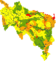
WFD Status for the River Wye and tributaries (project area outlined in red)
File history
Click on a date/time to view the file as it appeared at that time.
| Date/Time | Thumbnail | Dimensions | User | Comment | |
|---|---|---|---|---|---|
| current | 13:17, 15 September 2014 |  | 385 × 421 (42 KB) | Eldridge123 (talk | contribs) | The Wye catchment area |
| 13:02, 15 September 2014 |  | 385 × 421 (42 KB) | Eldridge123 (talk | contribs) | Wye (Herefordshire) Improvement Project (WHIP2) | |
| 12:59, 15 September 2014 |  | 385 × 421 (42 KB) | Eldridge123 (talk | contribs) | WFD Status for the River Wye and tributaries (project area outlined in red) |
You cannot overwrite this file.
File usage
The following page uses this file:
