Case study:Restoration of Ingarskilanjoki River
This case study is pending approval by a RiverWiki administrator.
Project overview
| Status | Complete |
|---|---|
| Project web site | |
| Themes | Habitat and biodiversity |
| Country | Finland |
| Main contact forename | Harri |
| Main contact surname | Aulaskari |
| Main contact user ID | |
| Contact organisation | Centre for Economic Development, Transport and the Environment for Uusimaa |
| Contact organisation web site | |
| Partner organisations | |
| Parent multi-site project | |
| This is a parent project encompassing the following projects |
No |
Project summary
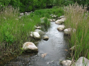
The Ingarskilanjoki River is 50 km long and runs into the Gulf of Finland. The Ingarskilanjoki River is the only river in Finland where the population of extremely endangered migrating sea trout (Salmo trutta) is natural, not from stocking. Due to flooding of the fields the river was straightened and dredged in 1988. The river was restored in 2002-2007 to recreate habitats for trout and its reproduction for the whole river length. The goal of the restoration was increasing the morphological diversity of the river by e.g. creating more variation of depths and meanders and adding gravel for fish spawning. The goal was also to take care of that the trout were able to migrate between river and sea. In addition buffer strips were created to the catchment to decrease the nutrient loading and turbidity of the river water. The local land owners and river side inhabitants were interviewed in order to take into account their opinions due to restoration. To ensure the recovery of the natural sea trout population, the trout fishing was prohibited in the river after the restoration. Before the dredging of the river, natural trout were caught and raised for further farming. After the dredging, caught trout from the natural population were stocked back to the river. However, because of the clearing and lost habitats, the reproduction of the trout had been weakened. The key success factor was that the decision of the preservation was made by the local fishing society. This is most likely the reason for that the fishing restriction has been obeyed which again is has been crucial for the balancing the sea trout reproduction and population. Since strict fishing restrictions, restorations and additional fish stockings the local trout population has grown which tells that the restoration as a whole was succeeded.
Monitoring surveys and results
Lessons learnt
Catchment and subcatchment
Edit the catchment and subcatchment details
(affects all case studies in this subcatchment)
Catchment
| River basin district | |
|---|---|
| River basin | Ingarskilanjoki River Basin |
Subcatchment
| River name | Ingarskilanjoki River |
|---|---|
| Area category | 100 - 1000 km² |
| Area (km2) | 160 km²16,000 ha <br /> |
| Maximum altitude category | |
| Maximum altitude (m) | |
| Dominant geology | Organic (i.e. Peat) |
| Ecoregion | Fenno-Scandian Shield |
| Dominant land cover | |
| Waterbody ID |
Site
| Name | Catchment of Ingarskilanjoki River |
|---|---|
| WFD water body codes | |
| WFD (national) typology | |
| WFD water body name | |
| Pre-project morphology | Straightened, Dredged |
| Reference morphology | |
| Desired post project morphology | |
| Heavily modified water body | |
| National/international site designation | |
| Local/regional site designations | multiple designations across the site |
| Protected species present | |
| Invasive species present | |
| Species of interest | |
| Dominant hydrology | |
| Dominant substrate | |
| River corridor land use | Intensive agriculture (arable) |
| Average bankfull channel width category | |
| Average bankfull channel width (m) | |
| Average bankfull channel depth category | |
| Average bankfull channel depth (m) | |
| Mean discharge category | |
| Mean annual discharge (m3/s) | |
| Average channel gradient category | |
| Average channel gradient | |
| Average unit stream power (W/m2) |
Project background
| Reach length directly affected (m) | |
|---|---|
| Project started | 2002/01/01 |
| Works started | |
| Works completed | 2007/01/01 |
| Project completed | |
| Total cost category | |
| Total cost (k€) | |
| Benefit to cost ratio | |
| Funding sources |
Cost for project phases
| Phase | cost category | cost exact (k€) | Lead organisation | Contact forename | Contact surname |
|---|---|---|---|---|---|
| Investigation and design | |||||
| Stakeholder engagement and communication | |||||
| Works and works supervision | |||||
| Post-project management and maintenance | |||||
| Monitoring |
Reasons for river restoration
Measures
Structural measures
| |
|---|---|
| Bank/bed modifications | Building fishways, depth variation, Introducing gravel, Re-introducing stones |
| Floodplain / River corridor | creation of buffer strips |
| Planform / Channel pattern | |
| Other | |
Non-structural measures
| |
| Management interventions | |
| Social measures (incl. engagement) | |
| Other | Participation in design, Information provision |
Monitoring
Hydromorphological quality elements
| Element | When monitored | Type of monitoring | Control site used | Result | ||
|---|---|---|---|---|---|---|
| Before measures | After measures | Qualitative | Quantitative | |||
| [[]] | ||||||
Biological quality elements
| Element | When monitored | Type of monitoring | Control site used | Result | ||
|---|---|---|---|---|---|---|
| Before measures | After measures | Qualitative | Quantitative | |||
| Fish: Abundance | Improvement | |||||
Physico-chemical quality elements
| Element | When monitored | Type of monitoring | Control site used | Result | ||
|---|---|---|---|---|---|---|
| Before measures | After measures | Qualitative | Quantitative | |||
| [[]] | ||||||
Any other monitoring, e.g. social, economic
| Element | When monitored | Type of monitoring | Control site used | Result | ||
|---|---|---|---|---|---|---|
| Before measures | After measures | Qualitative | Quantitative | |||
Monitoring documents
Image gallery
Additional documents and videos
Additional links and references
| Link | Description |
|---|


