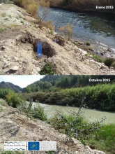
Case study:LIFE Segura Riverlink (Through rivers)
This case study is pending approval by a RiverWiki administrator.
Project overview
| Status | Complete |
|---|---|
| Project web site | http://https://www.chsegura.es/chs/cuenca/segurariverlink/contacto/ |
| Themes | Fisheries, Flood risk management, Habitat and biodiversity, Hydromorphology, Monitoring |
| Country | Spain |
| Main contact forename | Eduardo |
| Main contact surname | Lafuente |
| Main contact user ID | |
| Contact organisation | Confederación Hidrográfica del Segura |
| Contact organisation web site | http://https://www.chsegura.es/chs/cuenca/segurariverlink/riverlink/ |
| Partner organisations | Confederación Hidrográfica del Segura (CHS), Centro Tecnológico Agrario y Agroalimentario de la Universidad de Valladolid (ITAGRA-CT), Universidad de Murcia (UMU), Dirección General de Medio Ambiente de la Región de Murcia (CARM) & Asociación de Naturalistas del Sureste (ANSE) |
| Parent multi-site project | |
| This is a parent project encompassing the following projects |
No |
Project summary
The main objective of the project is to promote and support the environmental recovery of the Segura River Basin by improving and strengthening the connectivity between natural ecosystems, promoting the conservation of the area and improving its public use by:
1. Increasing the river ecosystems continuity and permeability in order to restore its natural dynamics and the mobility of the species along the Segura and Moratalla rivers
2. Combating ecosystem degradation and fragmentation to restore their role as ecological corridors
3. Improving the ecological status along both rivers
4. Increasing biodiversity of fluvial and riparian ecosystems
5. Promoting social awareness
6. Disseminating knowledge and transferring the results to the Segura River Basin Management Plan and to other areas with similar environmental problems
Monitoring surveys and results
In order to validate these actions and evaluate the results, the project carried out a comprehensive monitoring program including biological, physical-chemical and hydromorphological indicators. This facilitated the subsequent transfer to the rest of the basin and other rivers with similar problems.
Monitoting actions were focused on :
+ Operation indicators at fish passage systems
+ Fish community and populations
+ Bird community and riverbanks associated fauna
+ Spatio-temporal dynamics of vegetation communities in the restored areas
+ Ecological status of water bodies and sediment monitoring in each weir
Lessons learnt
Image gallery
|
Catchment and subcatchmentSelect a catchment/subcatchment
Catchment
Subcatchment
Other case studies in this subcatchment: Segura's River Bioremediation, Strengthening associated biodiversity of habitat 92A0 and control of Invasive Alien Species in the Segura River (LIFE + Ripisilvanatura)
Site
Project background
Cost for project phases
Reasons for river restoration
Measures
MonitoringHydromorphological quality elements
Biological quality elements
Physico-chemical quality elements
Any other monitoring, e.g. social, economic
Monitoring documents
Additional documents and videos
Additional links and references
Supplementary InformationEdit Supplementary Information THANKS FOR YOUR INTEREST IN THIS PROJECT! To contact us with any questions, suggestions or for more information please send an email to segurariverlink@chsegura.es or do it through social networks: Ripisilvanatura on Facebook : Segurariverlink Ripisilvanatura on Twitter : @segurariverlink
| ||||||||||||||||||||||||||||||||||||||||||||||||||||||||||||||||||||||||||||||||||||||||||||||||||||||||||||||||||||||||||||||||||||||||||||||||||||||||||||||||||||||||||||||||||||||||||||||||||||||||


