Case study:Restoration of Porvoonjoki
This case study is pending approval by a RiverWiki administrator.
Project overview
| Status | Complete |
|---|---|
| Project web site | |
| Themes | |
| Country | Finland |
| Main contact forename | Vainio |
| Main contact surname | Sampo |
| Main contact user ID | User:Kasvio |
| Contact organisation | Itä-Uudenmaan ja porvoonjoen vesi- ja ilmansuojeluyhdistys |
| Contact organisation web site | |
| Partner organisations | |
| This is a parent project encompassing the following projects |
Project summary
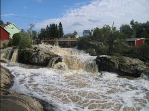
The river Porvoonjoki is the main river of the catchment area of the Porvoonjoki. The river runs from Lahti region to the City of Porvoo. It passes by many agricultural fields that are highly culturally significant to the area. The river is 143 km long anf the catchment area is 1 271 km2. The catchment area has only 1,4 % of lakes. The delta of the Porvoonjoki river is a Natura2000 area. The current has been more than 200 m3/s. The river has several rapid areas and 18 rapids have been restored to help the fish to migrate upwards the river. May restoration were done in the triburatory of the main river. Also fish (roe boxes and juveniles) have been introduced to the rapid areas. The fish populations have not risen as hoped due to the fishing and the obstacles to migrate.
Most of restoration actions are done by the local volunteers. In most of the restoration cases the rapids have received gravel, stones and also the paths for migratory fish have been opened. The stones will modify the current in the streams and give shelter areas for the fish. The gravel gives the salmonid fish places to reproduce and lay eggs.
The river is naturally very humid because of the loamy bottom. Agriculture and the sewage water from the domestic areas affects to the nutrient load to the river significantly. Buffer strips along the river have been established to prevent the nutrient load to the river. Fish studies have proven that the sewage waters that contain wastes from medicine affects the reproduction of the salmonid fish. The water quality In the river is getting better because of the better seage water management systems and water conservations actions in the agricultural areas.
The river is very popular as a recreational area. Many turists come to Porvoo for recreational fishing and to canoe in the River Porvoonjoki. There are many fish species in the River Porvoonjoki: salmo trutta, salmo salar, grayling, perch, pike, char.
There are several small hydropower stations along the River Porvoonjoki and its streams. Also there has been many old saws and mills but many of them have been opened up and now the fish can migrate upwards.
Monitoring surveys and results
Lessons learnt
Thanks to the local volunteers the restorations have been very succesfull and now the salmonid fish and many other fish species have better conditions to live and reproduce in the river. Still there are many barriers to the migratory fish and those issues need to be taking into consideratin in the future.
Image gallery
|
Catchment and subcatchment
Site
Project background
Cost for project phases
Reasons for river restoration
Measures
MonitoringHydromorphological quality elements
Biological quality elements
Physico-chemical quality elements
Any other monitoring, e.g. social, economic
Monitoring documents
Additional documents and videos
Additional links and references
Supplementary InformationEdit Supplementary Information
| ||||||||||||||||||||||||||||||||||||||||||||||||||||||||||||||||||||||||||||||||||||||||||||||||||||||||||||||||||||||||||||||||||||||||||||||||||||||||||||||||||||||||||||||||||||||||||||||||||||


