Case study:Comal River Restoration: Difference between revisions
mNo edit summary |
No edit summary |
||
| Line 34: | Line 34: | ||
{{Case study subcatchment}} | {{Case study subcatchment}} | ||
{{Site}} | {{Site}} | ||
{{Project background}} | {{Project background | ||
|Project started=2013 | |||
}} | |||
{{Motivations}} | {{Motivations}} | ||
{{Measures}} | {{Measures}} | ||
Revision as of 13:53, 14 November 2018
This case study is pending approval by a RiverWiki administrator.
Project overview
| Status | In progress |
|---|---|
| Project web site | http://www.eahcp.org/ |
| Themes | Habitat and biodiversity |
| Country | USA |
| Main contact forename | Casey |
| Main contact surname | Williams |
| Main contact user ID | |
| Contact organisation | BIO-WEST inc. |
| Contact organisation web site | |
| Partner organisations | |
| Parent multi-site project | |
| This is a parent project encompassing the following projects |
No |
Project summary
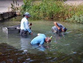
The Edwards Aquifer Recovery Implementation Plan (EARIP) process led to development of the approved Habitat Conservation Plan (HCP) for the Comal Springs and Comal River system (Comal system) in New Braunfels, Texas. In relation to the Comal system, the EARIP process and HCP identifies a variety of options to improve and increase habitat of threatened and endangered species, including the fountain darter (Etheostoma fonticola), Comal Springs salamander (Eurycea sp.), Comal Springs riffle beetle (Heterelmis comalensis), Peck’s cave amphipod (Stygobromus pecki) and the Comal Springs dryopid beetle (Stygoparnus comalensis). The aquatic vegetation restoration conducted in these two Project Areas in 2013 contributes to implementation of Phase I of the HCP. At specific locations within these Project Areas, non-native vegetation species have become predominant. Increasing native vegetation will benefit the fountain darter by increasing available habitat and improving the quality of existing habitat, potentially resulting in higher fountain darter densities in these areas. Improvement of, and increased areas of, fountain darter habitat is also beneficial to many other native aquatic species. During Phase 1 and beyond, the Aquatic Vegetation Restoration in Landa Lake and Habitat Restoration in the Old Channel are vital to provide the protection necessary to support the species of concern while uncertainty regarding habitat change, species’ response, and effects of other related HCP projects are being addressed.
Monitoring surveys and results
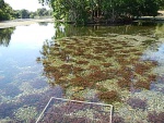
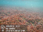
Monitoring of aquatic vegetation, especially during the prolonged drought that central Texas has been experiencing, is important to understanding potential impacts to fountain darters. Bryophytes (mosses) hold high densities of fountain darters and can be abundant in select locations of the Comal system (e.g., Upper Spring Run upstream of Landa Lake and in the upper portion of Landa Lake). Bryophyte stands in Landa Lake remained relatively constant between 2011-2012 (Figure 2). Cabomba, another native plant with relatively high densities of fountain darters, has been increasing in coverage in Landa Lake, and by fall 2012 it had the highest coverage that has been observed over the course of the study (Figure 2). In contrast, the aquatic vegetation in the Old Channel exemplifies the interactions between native (Lugwigia) and non-native (Hygrophila) aquatic vegetation in the river. Over the past several years, Ludwigia has become sparse (filamentous algae is rarely present), while Hygrophila has come to dominate most of the reach (Figure 3). Hygrophila flourishes in the Old Channel, and has been crowding out native Ludwigia (which has higher fountain darter densities) over the last several years. Ludwigia declined over the course of 2012 and is near the lowest coverage observed over the past decade. Bryophytes significantly increased in coverage during 2012, a ten-fold increase to the highest coverage ever observed at the Old Channel Reach. Since high densities of fountain darters occupy bryophytes in the Comal River, this could mean increased populations of the endangered fish if bryophytes remain in the Old Channel Reach. Filamentous algae, which covered a significant portion of this reach in the past, were still absent from the reach in 2012.
Lessons learnt
Image gallery
|
Catchment and subcatchment
Site
Project background
Cost for project phases
Reasons for river restoration
Measures
MonitoringHydromorphological quality elements
Biological quality elements
Physico-chemical quality elements
Any other monitoring, e.g. social, economic
Monitoring documents
Additional documents and videos
Additional links and references
Supplementary InformationEdit Supplementary Information
| ||||||||||||||||||||||||||||||||||||||||||||||||||||||||||||||||||||||||||||||||||||||||||||||||||||||||||||||||||||||||||||||||||||||||||||||||||||||||||||||||||||||||||||||||||


