Case study:Wettingen, nature-like fish pass: Difference between revisions
No edit summary |
No edit summary |
||
| Line 1: | Line 1: | ||
{{Case study status | {{Case study status | ||
|Approval status= | |Approval status=Approved | ||
}} | }} | ||
{{Location | {{Location | ||
Latest revision as of 11:02, 26 September 2013
Project overview
| Status | Complete |
|---|---|
| Project web site | |
| Themes | Economic aspects, Fisheries, Hydropower |
| Country | Switzerland |
| Main contact forename | Walter |
| Main contact surname | Binder |
| Main contact user ID | |
| Contact organisation | |
| Contact organisation web site | |
| Partner organisations | |
| Parent multi-site project | |
| This is a parent project encompassing the following projects |
No |
Project summary
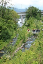
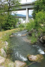
In Wettingen there is a great example of a small nature-like bypass channel at the weir Wettingen on the Limmat downstream from Zurich which surmounts the very big height of 18.30 m. Nature-like bypass channels total length is 620 m, discharge 0.4 m³/s and additional attraction water is 0.6 m³/s. Total difference in water level is 18.30 m with high mean slope 3 %.The lower section consists of a technical fish.
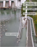
Whereas a near-nature water course was formed in the upper section, a rocky-cascade fishway with a height of 10 meters surmounts the biggest part of the altitude. Due to the limited space the
lower section consists of a vertical-slot-pass which is converted into a collection-gallery at the power house.
Leading back the water course to the power house is not possiblewhen it comes to bigger bypass channels.
Splitting the water into two branches offers a good solution for this small channel. The main branch continues towards the tailwater as a near-nature water course and ends further downstream, where a connection to the natural river bed is possible. The smaller second branch diverts from the main branch towards the power house and is formed as a vertical slot-pass.
The nature-like bypass channel has a trail on its side, so the residents can enjoy the lovely scenery and see some trouts when passing by.
Monitoring surveys and results
Lessons learnt
Image gallery
|
Catchment and subcatchment
Site
Project background
Cost for project phases
Reasons for river restoration
Measures
MonitoringHydromorphological quality elements
Biological quality elements
Physico-chemical quality elements
Any other monitoring, e.g. social, economic
Monitoring documents
Additional documents and videos
Additional links and references
Supplementary InformationEdit Supplementary Information
| ||||||||||||||||||||||||||||||||||||||||||||||||||||||||||||||||||||||||||||||||||||||||||||||||||||||||||||||||||||||||||||||||||||||||||||||||||||||||||||||||||||||||||||||||||


