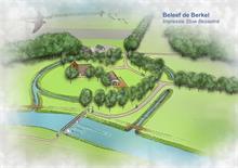
Case study:Beneden-Berkel: Difference between revisions
Jump to navigation
Jump to search
No edit summary |
No edit summary |
||
| Line 52: | Line 52: | ||
|Avrg channel gradient=0,00022 | |Avrg channel gradient=0,00022 | ||
}} | }} | ||
{{Project background}} | {{Project background | ||
|Project started=2013/09/01 | |||
|Funding sources=Waterschap Rijn & IJssel, Provincie Gelderland | |||
}} | |||
{{Motivations}} | {{Motivations}} | ||
{{Measures}} | {{Measures}} | ||
Revision as of 16:46, 18 September 2013
This case study is pending approval by a RiverWiki administrator.
Location: 52° 9' 15.66" N, 6° 17' 50.82" E
Left click to look around in the map, and use the wheel of your mouse to zoom in and out.
Project overview
| Status | In progress |
|---|---|
| Project web site | http://www.wrij.nl/thema'/actueel/projecten/berkel-almen/ |
| Themes | Habitat and biodiversity, Land use management - agriculture, Water quality |
| Country | Netherlands |
| Main contact forename | Ellen |
| Main contact surname | Bollen-Weide |
| Main contact user ID | |
| Contact organisation | |
| Contact organisation web site | http://www.wrij.nl/ |
| Partner organisations | Provincie Gelderland |
| Parent multi-site project | |
| This is a parent project encompassing the following projects |
No |
Project summary
Edit project overview to modify the project summary.
Since the Middle Ages man has been altering the Berkel. At first to make it navigable and from the 1930's onwards to reduce flooding. Over the years the Berkel has thus been modified into a straight monotonous river. Now, some of the natural characteristics of the area will be restored. This will allow many more species of plants and animals to live in and around the Berkel, and the water becomes cleaner.
The measures that will be taken are:
- remeandering and introduction of woody debris to create more variety in stream flow, water depth and plant growth;
- cascading fish passages will be made on the Besselink and Warken dams;
- land consolidation, to move production lands away from the low lying (thus wet) river banks, and closer to the farms, thus reducing distance travelled by farmers;
- a swimming pool and a walking path will be made, in order to better facilitate recreation.
Monitoring surveys and results
This case study hasn’t got any Monitoring survey and results, you can add some by editing the project overview.
Lessons learnt
This case study hasn’t got any lessons learnt, you can add some by editing the project overview.
Image gallery
|
Catchment and subcatchmentSelect a catchment/subcatchment
Catchment
Subcatchment
Site
Project background
Cost for project phases
Reasons for river restoration
Measures
MonitoringHydromorphological quality elements
Biological quality elements
Physico-chemical quality elements
Any other monitoring, e.g. social, economic
Monitoring documents
Additional documents and videos
Additional links and references
Supplementary InformationEdit Supplementary Information
| ||||||||||||||||||||||||||||||||||||||||||||||||||||||||||||||||||||||||||||||||||||||||||||||||||||||||||||||||||||||||||||||||||||||||||||||||||||||||||||||||||||||||||||||||||||||||||||||||||||||||

