Case study:Biomura LIFE06NAT/SI/000066: Difference between revisions
No edit summary |
No edit summary |
||
| Line 231: | Line 231: | ||
{{Additional links and references | {{Additional links and references | ||
|Link=www.biomura.si/ang/galerija.aspx | |Link=www.biomura.si/ang/galerija.aspx | ||
|Description= | |Description=photo gallery | ||
}} | }} | ||
{{Additional_links_and_references_footer}} | {{Additional_links_and_references_footer}} | ||
Revision as of 12:28, 30 May 2013
This case study is pending approval by a RiverWiki administrator.
Project overview
| Status | Complete |
|---|---|
| Project web site | http://www.biomura.si/default.aspx |
| Themes | |
| Country | Slovenia |
| Main contact forename | Lidija |
| Main contact surname | Globevnik |
| Main contact user ID | |
| Contact organisation | Institute for water of the Republic of Slovenia |
| Contact organisation web site | http://www.izvrs.si/ |
| Partner organisations | |
| Parent multi-site project | |
| This is a parent project encompassing the following projects |
No |

Project summary
Biomura LIFE06NAT/SI/000066
The BIOMURA project funded by the EU LIFE NATURA 2006 is among the first projects aiming at restoration of the degraded river morphology in Slovenia. Project goals was improvement of riparian and adjacent riverine habitats, protection of targeted endangered species and indirect implications for preservation of other animal and plant species and their habitats, increase of biodiversity and reservation of the natural landscape.
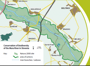
The area covered by the project has a surface of 1520 ha and is part of the Natura 2000 (SPA: SI5000010, pSCI: SI3000215). The area lies within high water protection embankments of the Mura River, between the villages of Bakovci, Dokležovje, Ižakovci, Melinci, Bunčani, Veržej, Krapje and Mota.
Intensive water use, activities in the river and riverside space and the change of land use in the Mura River catchment (chain of hydropower plants on the Mura in Austria, flood protection structures and facilities, water supply, management of agricultural land, urban development) have considerably altered the river space. At the border between Slovenia and Austria, the river bed of the Mura River has deepened in the last decades (by as much as 1.5 m; by 33 cm on average). This has changed the hydrological features of the Mura wetlands.
Although the Mura River has been straightened and the meanders cut-across, leaving behind oxbows, parts of the old channel are still recharged by the river, precipitation and groundwater. The processes of more relaxed, less controlled dynamics of the water flow, with a more frequent and easily spotted bank erosion, natural sediment transport and deposition, frequent flooding, river branches and oxbows, are especially present downstream of Veržej. The Mura river space in Slovenia, and at the reach bordering Croatia, is therefore among the richest ecosystems in Slovenia.
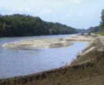
Proposed measures and actions: (C1) connecting the main river channel with the side branches; (C2) establishing conditions for appropriate water level at the site of the water inflow into side branches (more frequent and higher water level in the main channel, which enables the inflow of water into side branches at average and lower discharges); (C3) widening of the main channel where erosion channel banks and gravel bars will be formed; (C4) presentation of sustainable alluvial forest maintenance; (D1) sustainable maintenance (restoration) of side branches; (D2) establishing a system of smaller inflow/ outflow structures and mechanisms (wooden lock lifters, openings) in the chosen sites in the area of oxbow lakes and branches; (E7) local information centre Mota; (E8) regional promotional centre in Murska Sobota; (E9) information trail Veržej – Ižakovci (E1-E6, E10-E12), workshops, promotional and informational actions and sources: webpage, information bulletins, brochure, film.
The activities of the BIOMURA project aimed at improvement of growing conditions for 4 habitats from the Habitats Directive: Alnus glutinosa in Fraxinus excelsior, (Alno-Padion, Alnion incanae, Salicion albae); Quercus robur, Ulmus laevis in Ulmus minor, Fraxinus excelsior ali Fraxinus angustifolia; Rununculion fluitantis in Callitricho-Batrachion; Hydrophilous tall herb fringe communities of plains and of the montane to alpine levels. The conservation of targeted species for more than a third of the Natura 2000 qualification species on the Mura river should be ensured. Targeted species from that Annex II to the Habitats Directive include: 1 butterfly species (Callimorpha quadripunctaria), 1 amphibian species (Bombina bombina), 1 dragonfly species (Ophiogomphus cecilia) and 5 fish species (Misgurnus fossilis, Rhodeus sericeus amarus, Gymnocephalus schraetzer, Umbra krameri, Aspius aspius). Also, it is assumed that the living conditions of 29 other species of birds, butterflies, dragonflies, amphibians, reptiles and mammals improved.
Monitoring surveys and results
Lessons learnt
Catchment and subcatchment
Edit the catchment and subcatchment details
(affects all case studies in this subcatchment)
Catchment
| River basin district | Big River |
|---|---|
| River basin | Big River |
Subcatchment
| River name | Mura River |
|---|---|
| Area category | 1000 - 10000 km² |
| Area (km2) | |
| Maximum altitude category | |
| Maximum altitude (m) | |
| Dominant geology | |
| Ecoregion | Hungarian Lowlands |
| Dominant land cover | Woodland, Urban, Extensive agriculture |
| Waterbody ID |
Site
| Name | and Melinci |
|---|---|
| WFD water body codes | |
| WFD (national) typology | VT Kučnica Mura Petanjci – Gibina |
| WFD water body name | |
| Pre-project morphology | |
| Reference morphology | Braided |
| Desired post project morphology | |
| Heavily modified water body | |
| National/international site designation | |
| Local/regional site designations | |
| Protected species present | |
| Invasive species present | |
| Species of interest | |
| Dominant hydrology | Groundwater |
| Dominant substrate | Silt, Sand, Gravel |
| River corridor land use | Woodland, Wetland, Urban, Extensive agriculture |
| Average bankfull channel width category | |
| Average bankfull channel width (m) | |
| Average bankfull channel depth category | |
| Average bankfull channel depth (m) | |
| Mean discharge category | |
| Mean annual discharge (m3/s) | |
| Average channel gradient category | |
| Average channel gradient | |
| Average unit stream power (W/m2) |
Project background
| Reach length directly affected (m) | 8000 m8 km <br />800,000 cm <br /> |
|---|---|
| Project started | 2006/10/01 |
| Works started | |
| Works completed | 2011/10/01 |
| Project completed | |
| Total cost category | 1000 - 5000 k€ |
| Total cost (k€) | 2000 k€2,000,000 € <br /> |
| Benefit to cost ratio | |
| Funding sources | EU (Life Nature programme), Ministry for environment and spatial planning, Institute for water of the Republic of Slovenia, other partners (IZVO, Mura VGP, RRA Mura, Prleska RA, DOPPS, ZrsVN Maribor, WWF) |
Cost for project phases
| Phase | cost category | cost exact (k€) | Lead organisation | Contact forename | Contact surname |
|---|---|---|---|---|---|
| Investigation and design | Institute for water of the Republic of Slovenia | ||||
| Stakeholder engagement and communication | |||||
| Works and works supervision | |||||
| Post-project management and maintenance | |||||
| Monitoring |
Reasons for river restoration
| Mitigation of a pressure | |
|---|---|
| Hydromorphology | |
| Biology | |
| Physico-chemical | |
| Other reasons for the project |
Measures
Structural measures
| |
|---|---|
| Bank/bed modifications | natural erosion embankments, connection between river channel and former side branches, expansion of river bed on some parts of the river, new gravel bars |
| Floodplain / River corridor | Partially filled river sleeves - restored and cleaned of debris, new river oxbows |
| Planform / Channel pattern | |
| Other | |
Non-structural measures
| |
| Management interventions | |
| Social measures (incl. engagement) | |
| Other | |
Monitoring
Hydromorphological quality elements
| Element | When monitored | Type of monitoring | Control site used | Result | ||
|---|---|---|---|---|---|---|
| Before measures | After measures | Qualitative | Quantitative | |||
Biological quality elements
| Element | When monitored | Type of monitoring | Control site used | Result | ||
|---|---|---|---|---|---|---|
| Before measures | After measures | Qualitative | Quantitative | |||
Physico-chemical quality elements
| Element | When monitored | Type of monitoring | Control site used | Result | ||
|---|---|---|---|---|---|---|
| Before measures | After measures | Qualitative | Quantitative | |||
Any other monitoring, e.g. social, economic
| Element | When monitored | Type of monitoring | Control site used | Result | ||
|---|---|---|---|---|---|---|
| Before measures | After measures | Qualitative | Quantitative | |||
Monitoring documents
Image gallery
Additional documents and videos
Additional links and references
| Link | Description |
|---|---|
| http://www.biomura.si/prenosi/casopis%20Biomura/BioMura zgibanka1 ang.pdf | project summary |
| http://www.biomura.si/ang/galerija.aspx | photo gallery |

