Case study:Hainburg River Restoration: Difference between revisions
No edit summary |
No edit summary |
||
| Line 35: | Line 35: | ||
{{Toggle button}} | {{Toggle button}} | ||
{{Toggle content start}} | {{Toggle content start}} | ||
{{Case study subcatchment}} | {{Case study subcatchment | ||
|Subcatchment=Danube | |||
}} | |||
{{Site}} | {{Site}} | ||
{{Project background}} | {{Project background}} | ||
Revision as of 12:51, 17 September 2013
This case study is pending approval by a RiverWiki administrator.
Project overview
| Status | Complete |
|---|---|
| Project web site | http://www.donauauen.at/?story_id=1713 |
| Themes | Flood risk management, Habitat and biodiversity, Hydromorphology |
| Country | Austria |
| Main contact forename | Stefan |
| Main contact surname | Schneeweihs |
| Main contact user ID | User:Nationalpark Donau-Auen |
| Contact organisation | Nationalpark Donau-Auen |
| Contact organisation web site | http://http://www.donauauen.at/?area=nationalpark&language=english |
| Partner organisations | via donau |
| Parent multi-site project | |
| This is a parent project encompassing the following projects |
No |
Project summary
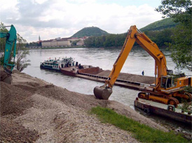
This project involved the removal of all artificial elements strengthening the banks of a river section on the Danube's left bank across from the city Hainburg. In the entire lower section of the project area, all stone and boulder supports were removed from a length of around 2.1 km. Because the upper section exhibited a nascent overhanging bank character, it was necessary to safeguard the embankment at the height of the regulated low water level, heeding however navigational requirements.
In the long term, the new riverbank should
- allow a natural and structurally multi-facetted riverbank landscape to develop
- bring about a continuous lateral shift of the bank edge and thus cultivate the associated erosion, siltation, and fluctuation zones and keep these in dynamic interplay in the long run
- work to counteract the formation of riverbank formations
- intensify the extent to which high water can replenish the riparian woods, inflow channels and bodies of water
- improve the groundwater connection between main stem and wetlands and keep it open in the years to come.
Indeed, shortly after construction had ended, the restoration potential of the landscape became clear: the flowing water had caused the river bank line to recede. After only a few months, the first signs of riverine habitat rejuvenation were observed in the flat sections of the inside bends. In particular the pioneer sites, the early succession stages and the wetland meadows were aided. Thus the highly-endangered species which find their home in these wetland habitats will be able to utilise them for a long time to come.
Monitoring surveys and results
Lessons learnt
Image gallery
|
Catchment and subcatchmentSelect a catchment/subcatchment
Catchment
Subcatchment
Other case studies in this subcatchment: Conservation of alluvial, INTERREG MED WETNET - Memoradum on Participation in Wetland Conservation in Ljubljansko Barje Nature Park, Marsh protection in Egyek–Pusztakócs, National Park Danube-Auen, Regelsbrunner Aue, Renaturation of Stržen's riverbed on intermittent Cerknica Lake, The Bulgarian Wetlands Restoration and Pollution Reduction Project, Witzelsdorf Pilot Project
Site
Project background
Cost for project phases
Reasons for river restoration
Measures
MonitoringHydromorphological quality elements
Biological quality elements
Physico-chemical quality elements
Any other monitoring, e.g. social, economic
Monitoring documents
Additional documents and videos
Additional links and references
Supplementary InformationEdit Supplementary Information
| ||||||||||||||||||||||||||||||||||||||||||||||||||||||||||||||||||||||||||||||||||||||||||||||||||||||||||||||||||||||||||||||||||||||||||||||||||||||||||||||||||||||||||||||||||||||||||||||||||||||||

