Case study:Eldbäcken: Difference between revisions
No edit summary |
No edit summary |
||
| (15 intermediate revisions by 2 users not shown) | |||
| Line 1: | Line 1: | ||
{{Case study status | {{Case study status | ||
|Approval status= | |Approval status=Approved | ||
}} | }} | ||
{{Location | {{Location | ||
| Line 15: | Line 15: | ||
|Contact organisation url=www.nrrv.se | |Contact organisation url=www.nrrv.se | ||
|Multi-site=No | |Multi-site=No | ||
|Project summary=Eldbäcken is a more diverse version of a nature-like bypass channel, a fishway type that we | |Project picture=Eldbacken.PNG | ||
|Picture description=Eldbäcken, biokanal (photo by Olle Calles) | |||
|Project summary=Eldbäcken is a more diverse version of a nature-like bypass channel, a fishway type that we call “biocanal”. The name derives from the fact that the fishway is constructed not only to facilitates passage, but also to contain additional habitats and thereby compensate for the loss of biodiversity which often is the result in regulated rivers. | |||
The biocanal was constructed in 2009 in the Västerdalälven river system, in the province of Dalarna in central Sweden, diverting water around the Eldforsen hydroelectric power plant and into the old river bed. The biocanal has a head of 5 m and a length of 500 m, resulting in a gradient of 1%. To make the flow as nature-like as possible, the intake of the biocanal is constructed to allow a variable flow regime. | The biocanal was constructed in 2009 in the Västerdalälven river system, in the province of Dalarna in central Sweden, diverting water around the Eldforsen hydroelectric power plant and into the old river bed. The biocanal has a head of 5 m and a length of 500 m, resulting in a gradient of 1%. To make the flow as nature-like as possible, the intake of the biocanal is constructed to allow a variable flow regime. | ||
| Line 27: | Line 29: | ||
4) Riffles, with a straight watercourse and higher water velocity, providing habitat for rheophilic taxa in general. | 4) Riffles, with a straight watercourse and higher water velocity, providing habitat for rheophilic taxa in general. | ||
}} | }} | ||
{{Image gallery}} | |||
{{Case study image | |||
|File name=P1090478.JPG | |||
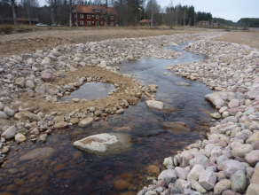
|Caption=Floodplain habitat during high flow conditions. Photo: Olle Calles | |||
}} | |||
{{Case study image | |||
|File name=P1090486.JPG | |||
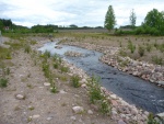
|Caption=Braided habitat during high flow conditions. Photo: Olle Calles | |||
}} | |||
{{Case study image | |||
|File name=Veg.jpg | |||
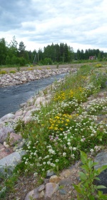
|Caption=Colonization of riparian vegetation in progress. Photo: Olle Calles | |||
}} | |||
{{Image gallery end}} | |||
{{Toggle button}} | |||
{{Toggle content start}} | |||
{{Case study subcatchment}} | {{Case study subcatchment}} | ||
{{Site}} | {{Site | ||
{{Project background}} | |Name=Eldbäcken | ||
|WFD water body name=River Västerdalälven | |||
|Heavily modified water body=Yes | |||
|Protected species present=No | |||
|Invasive species present=No | |||
|Species=Freshwater pearl mussel (Margaritifera margaritifera), Brown trout (Salmo trutta), | |||
|Dominant substrate=boulder, cobble | |||
|Average bankfull channel width category=2 - 5 m | |||
|Average bankfull channel depth category=0.5 - 2 m | |||
|Mean discharge category=0.1 - 1.0 m³/s | |||
|Average channel gradient category=0.001 - 0.01 | |||
}} | |||
{{Project background | |||
|Funding sources=Fortum Environmental Fund | |||
}} | |||
{{Motivations}} | {{Motivations}} | ||
{{Measures}} | {{Measures}} | ||
{{Hydromorphological quality elements header}} | {{Hydromorphological quality elements header}} | ||
{{Hydromorphological quality element table row | |||
|Element=Flow velocities | |||
|Monitored before=No | |||
|Monitored after=Yes | |||
|Qualitative monitoring=Yes | |||
|Quantitative monitoring=Yes | |||
|Control site used=Yes | |||
}} | |||
{{Hydromorphological quality element table row | |||
|Element=Substrate conditions | |||
|Monitored before=No | |||
|Monitored after=Yes | |||
|Qualitative monitoring=Yes | |||
|Quantitative monitoring=Yes | |||
|Control site used=Yes | |||
}} | |||
{{End table}} | {{End table}} | ||
{{Biological quality elements header}} | {{Biological quality elements header}} | ||
| Line 76: | Line 123: | ||
{{Monitoring documents}} | {{Monitoring documents}} | ||
{{Monitoring documents end}} | {{Monitoring documents end}} | ||
{{Additional Documents}} | {{Additional Documents}} | ||
{{Additional Documents end}} | {{Additional Documents end}} | ||
| Line 83: | Line 128: | ||
{{Additional links and references footer}} | {{Additional links and references footer}} | ||
{{Supplementary Information}} | {{Supplementary Information}} | ||
{{Toggle content end}} | |||
Latest revision as of 09:26, 6 September 2013
Project overview
| Status | Complete |
|---|---|
| Project web site | http://www.nrrv.se/ |
| Themes | Habitat and biodiversity, Hydropower |
| Country | Sweden |
| Main contact forename | Stina |
| Main contact surname | Gustafsson |
| Main contact user ID | |
| Contact organisation | Karlstad University |
| Contact organisation web site | http://www.nrrv.se |
| Partner organisations | |
| Parent multi-site project | |
| This is a parent project encompassing the following projects |
No |
Project summary
Eldbäcken is a more diverse version of a nature-like bypass channel, a fishway type that we call “biocanal”. The name derives from the fact that the fishway is constructed not only to facilitates passage, but also to contain additional habitats and thereby compensate for the loss of biodiversity which often is the result in regulated rivers.
The biocanal was constructed in 2009 in the Västerdalälven river system, in the province of Dalarna in central Sweden, diverting water around the Eldforsen hydroelectric power plant and into the old river bed. The biocanal has a head of 5 m and a length of 500 m, resulting in a gradient of 1%. To make the flow as nature-like as possible, the intake of the biocanal is constructed to allow a variable flow regime.
To increase the potential for a high biodiversity, four different habitat types, each replicated three times, were created within the biocanal:
1) Pools, with a low water velocity and gravel substrate to compensate for lost freshwater pearl mussel (Margaritifera margaritifera) habitat and spawning areas for brown trout (Salmo trutta).
2) Floodplains, with winding channels and shallow ponds and
3) Braided habitats, where the canal has been diverted into narrow channels with islands in-between. These two habitat types were created to accommodate young individuals of brown trout.
4) Riffles, with a straight watercourse and higher water velocity, providing habitat for rheophilic taxa in general.
Monitoring surveys and results
Lessons learnt
Image gallery
|
Catchment and subcatchment
Site
Project background
Cost for project phases
Reasons for river restoration
Measures
MonitoringHydromorphological quality elements
Biological quality elements
Physico-chemical quality elements
Any other monitoring, e.g. social, economic
Monitoring documents
Additional documents and videos
Additional links and references
Supplementary InformationEdit Supplementary Information
| ||||||||||||||||||||||||||||||||||||||||||||||||||||||||||||||||||||||||||||||||||||||||||||||||||||||||||||||||||||||||||||||||||||||||||||||||||||||||||||||||||||||||||||||||||||||||||||||||||||||||||||||||||||||||||||


