Case study:LIFE GREENCHANGE (LIFE17 NAT/IT/000619) – Construction of green infrastructures in the Fondazione Caetani farm – Restoration of the Fosso Epitaffio: Difference between revisions
No edit summary |
No edit summary |
||
| (4 intermediate revisions by one other user not shown) | |||
| Line 1: | Line 1: | ||
{{Case study status | {{Case study status | ||
|Approval status= | |Approval status=Approved | ||
}} | }} | ||
{{Location | {{Location | ||
| Line 33: | Line 33: | ||
{{Case study image | {{Case study image | ||
|File name=Schermata 2019-12-09 alle 15.21.44.png | |File name=Schermata 2019-12-09 alle 15.21.44.png | ||
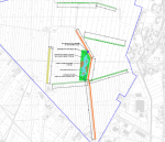
|Caption=Restoration project | |||
}} | }} | ||
{{Case study image | {{Case study image | ||
|File name=Schermata 2019-12-09 alle 15.21.54.png | |File name=Schermata 2019-12-09 alle 15.21.54.png | ||
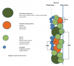
|Caption=Planting system | |Caption=Planting system | ||
}} | |||
{{Case study image | |||
|File name=Schermata 2019-12-09 alle 15.25.04.png | |||
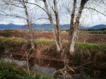
|Caption=Fosso Epitaffio | |||
}} | }} | ||
{{Image gallery end}} | {{Image gallery end}} | ||
| Line 47: | Line 52: | ||
|Name=Fondazione Caetani Farm (Municipality of Latina) | |Name=Fondazione Caetani Farm (Municipality of Latina) | ||
|Heavily modified water body=No | |Heavily modified water body=No | ||
|Protected species present= | |Protected species present=Yes | ||
|Invasive species present= | |Invasive species present=Yes | ||
|River corridor land use=Intensive agriculture (arable), | |River corridor land use=Intensive agriculture (arable), | ||
}} | }} | ||
| Line 61: | Line 66: | ||
|Specific mitigation=Riparian development, | |Specific mitigation=Riparian development, | ||
|Hydromorphological quality elements=Flow velocities, Freshwater flow regime, | |Hydromorphological quality elements=Flow velocities, Freshwater flow regime, | ||
|Biological quality elements=green infrastructure | |||
|Other motivation=Agriculture | |Other motivation=Agriculture | ||
}} | }} | ||
Latest revision as of 10:18, 25 February 2020
Project overview
| Status | Planned |
|---|---|
| Project web site | http://lifegreenchange.eu/en/ |
| Themes | Environmental flows and water resources, Habitat and biodiversity, Hydropower |
| Country | Italy |
| Main contact forename | Simonetta |
| Main contact surname | Dario |
| Main contact user ID | |
| Contact organisation | Confagricoltura Latina |
| Contact organisation web site | http://www.confagricolturalatina.it |
| Partner organisations | Provincial di Latina; U-space s.r.l.; MIEMA; Poliedra |
| Parent multi-site project | |
| This is a parent project encompassing the following projects |
No |
Project summary
This intervention is part of the project LIFE GREENCHANGE “GREEN INFRASTRUCTURES FOR INCREASING BIODIVERSITY IN AGRO PONTINO AND MALTESE RURAL AREAS” (LIFE17 NAT/IT/000619). In line with the objectives of the EU Biodiversity Strategy to 2020 and with the Communication from the Commission on Green Infrastructures, LIFE GREENCHANGE intends to contribute to halting the loss of biodiversity and to enhance the ecological value of the agricultural systems of the Agro Pontino and of the northern region of Malta, by planning and implementing Green Infrastructures and multifunctional actions in rural, semi-natural and natural areas.
This intervention is part of the Action 5 “Construction of green infrastructures in the Fondazione Caetani farm”. The action consists in the implementation of demonstration projects aimed at increasing biodiversity in the Caetani Foundation farm without loss in terms of productivity. The farm is involved in the construction, management and maintenance of the interventions through the signing of land stewardship agreement.
In particular, it consists of the Sub-action 5.1. “Restoration of the Fosso Epitaffio”. The Fosso Epitaffio is located inside the Fondazione Caetani farm crossing it diagonally from north to south, and is also the main hydraulic line belonging to the secondary network of the Agro Pontino Reclamation Consortium. - remodeling and extension of the river bank and creation of a riparian arboreous shrubland; - planting of hygrophilous shrub species, and a first band of elophytes (Phragmites australis, Typha latifolia) and a second with shrubby and planar shrubby and arboreal species (Salix spp, Populus spp, Ulmus minor, Quercus robur). - remodeling also some sections of the riverbed for the creation of different conditions of the river flow speed and morpho-bathymetric heterogeneity functional to fauna, especially amphibious. Multi-wire formations are foreseen, combining rows of only helophyte shrubs, and trees managed with coppice. Plantings of 2 ml were used for shrub species, 5 meters for tree species managed by coppice. The distance between the rows is at least 5 meters for tree species. The average hydraulic section is considerably enlarged by the remodeling action, thus not prejudicing the liquid transport capacity of the rod. The distances between the rows and on the row will be maintained even if they are used in the planting, a provision that is closest to the natural one, both as regards the species and the position. The work will have a linear development of 1,300 ml for a total width of 10 ml. The creation of the vegetated strip will affect approximately 5m only on the left bank of the ditch, allowing the reconstitution of a transversal and longitudinal river continuum to the watercourse capable of performing important naturalistic, landscape and mitigation of the percolating polluting load. The remodeling will allow to obtain also different conditions of current velocity and morpho-bathymetric heterogeneity functional to the above all amphibian fauna.
Monitoring surveys and results
Lessons learnt
Image gallery
|
Catchment and subcatchmentSelect a catchment/subcatchment
Catchment
Subcatchment
Site
Project background
Cost for project phases
Reasons for river restoration
Measures
MonitoringHydromorphological quality elements
Biological quality elements
Physico-chemical quality elements
Any other monitoring, e.g. social, economic
Monitoring documents
Additional documents and videos
Additional links and references
Supplementary InformationEdit Supplementary Information
| ||||||||||||||||||||||||||||||||||||||||||||||||||||||||||||||||||||||||||||||||||||||||||||||||||||||||||||||||||||||||||||||||||||||||||||||||||||||||||||||||||||||||||||||||||||||||||||||||||||||||


