Case study:LIFE Segura Riverlink (Through rivers): Difference between revisions
No edit summary |
No edit summary |
||
| (22 intermediate revisions by one other user not shown) | |||
| Line 1: | Line 1: | ||
{{Case study status | {{Case study status | ||
|Approval status= | |Approval status=Approved | ||
}} | |||
{{Location | |||
|Location=38.234218515247726, -1.5045774344746405 | |||
}} | }} | ||
{{Project overview | {{Project overview | ||
|Status=Complete | |Status=Complete | ||
| Line 42: | Line 44: | ||
+ Ecological status of water bodies and sediment monitoring in each weir | + Ecological status of water bodies and sediment monitoring in each weir | ||
|Lessons learn=Upon completion of the project, the following results have been listed: | |||
+ More than 10,000 fish are using the fish passages. 80% of fishes which try to use the vertical-slot fishway achieves it, 50% does it in less than half an hour. | |||
+ First weir removal within the Segura Basin | |||
+ Volunteer collaboration and the landstewardship scheme are essential for the achievement of a favorable development of the riparian vegetation. In case of volunteers, thanks to its implication in plantation and refered to landowners for their commitment to properly mantain riversides and to avoid the development of alien species spots as in the case of Arundo Donax. | |||
+ Results obtained by the removal of Arundo Donax have been diverse, depending on the area and the technique applied. | |||
+ Plantation has been more effective for willows (Salix sp), poplars (Populus sp.), elms (Ulmus minor), mastic trees (Pistacia lentiscus) and rosebay (Nerium oleander). | |||
+ A proper implementation of the plantations, a good size of the holes, the location of each plant and the time of plantig are essential for the succes of the works. | |||
+ One of the most succesful achievements has been giving visibility to the problem and to the project and the social awareness about it. | |||
|Project title=LIFE Segura Riverlink (Through rivers) | |Project title=LIFE Segura Riverlink (Through rivers) | ||
}} | }} | ||
{{Image gallery}} | {{Image gallery}} | ||
{{Case study image | |||
|File name=Ambito-actuacion-proyecto-life.jpg | |||
|Caption=Scope of action | |||
}} | |||
{{Case study image | {{Case study image | ||
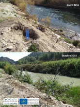
|File name=Riverlink - demolicion azud moratalla.jpg | |File name=Riverlink - demolicion azud moratalla.jpg | ||
|Caption=Removal of the Moratalla weir | |||
}} | }} | ||
{{Case study image | {{Case study image | ||
|File name=Riverlink - plantacion azud los charcos.jpg | |File name=Riverlink - plantacion azud los charcos.jpg | ||
|Caption=Riparian vegetation plantation in "Los Charcos" | |||
}} | }} | ||
{{Case study image | {{Case study image | ||
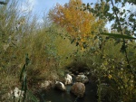
|File name=Riverlink - restauracion hoya garcia.jpg | |File name=Riverlink - restauracion hoya garcia.jpg | ||
|Caption=Landowners meeting in Hoya Garcia | |||
}} | |||
{{Case study image | |||
|File name=Riverlink Escala de peces.jpg | |||
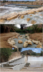
|Caption=Fish ladder | |||
}} | |||
{{Case study image | |||
|File name=FISH PASSAGES.png | |||
|Caption=Fish passages | |||
}} | }} | ||
{{Image gallery end}} | {{Image gallery end}} | ||
| Line 60: | Line 92: | ||
|Subcatchment=Segura | |Subcatchment=Segura | ||
}} | }} | ||
{{Site}} | {{Site | ||
|Name=río Segura entre Cañaverosa y Abarán, de aproximadamente 54 km de longitud, y en el tramo final del río Benamor hasta su confluencia con el río Segura | |||
|WFD (national) typology=R-T14 & R-T16, | |||
|WFD water body name=Segura River | |||
|Heavily modified water body=No | |||
|Site designation=All - multiple designations across the site | |||
|Local site designation=SCI (Site of Commnuty Interest), Special Protection Zones for Birds (SPA), Special Areas of Conservation (SAC), Nature reserve, Protected Natural Space (PNS) | |||
|Protected species present=No | |||
|Invasive species present=Yes | |||
|River corridor land use=Intensive agriculture (arable), Plantation forestry, Urban, | |||
}} | |||
{{Project background | {{Project background | ||
|Reach length directly affected=54000 | |Reach length directly affected=54000 | ||
| Line 74: | Line 116: | ||
|Other motivation=Removal of fish barriers and construction of fish passages | |Other motivation=Removal of fish barriers and construction of fish passages | ||
}} | }} | ||
{{Measures}} | {{Measures | ||
|Bank and bed modifications measure=Planting of native species, Removal of invasive species, Structuring of shoreline, Weir removal, Creation of fish passes, | |||
|Floodplain / River corridor=Improving fish migration, Alloctone species control, | |||
|Management interventions=Management of undesirable plant species, Implementation of best practice land & soil management, Promotion of riparian vegetation and natural re-growth of bankside, Riparian tree planting, Removal of invasive species | |||
|Social measures=Volunteer engagement, Creation of a Land Stewardship Network, Community education (talks and workshops | |||
}} | |||
{{Hydromorphological quality elements header}} | {{Hydromorphological quality elements header}} | ||
{{Hydromorphological quality element table row | |||
|Element=Structure & condition of riparian/lake shore zones | |||
|Monitored before=Yes | |||
|Monitored after=Yes | |||
|Qualitative monitoring=Yes | |||
|Quantitative monitoring=Yes | |||
|Control site used=Yes | |||
|Result=Improvement | |||
}} | |||
{{End table}} | {{End table}} | ||
{{Biological quality elements header}} | {{Biological quality elements header}} | ||
{{Biological quality element table row | |||
|Element=Invertebrates | |||
|Monitored before=Yes | |||
|Monitored after=Yes | |||
|Qualitative monitoring=Yes | |||
|Quantitative monitoring=Yes | |||
|Control site used=No | |||
|Result=No change | |||
}} | |||
{{Biological quality element table row | |||
|Element=Macrophytes and/or phytobenthos: Average abundance | |||
|Monitored before=Yes | |||
|Monitored after=Yes | |||
|Qualitative monitoring=No | |||
|Quantitative monitoring=Yes | |||
|Control site used=No | |||
|Result=No change | |||
}} | |||
{{End table}} | {{End table}} | ||
{{Physico-chemical quality elements header}} | {{Physico-chemical quality elements header}} | ||
{{Physico-chemical quality element table row | |||
|Element=Temperature | |||
|Monitored before=Yes | |||
|Monitored after=Yes | |||
|Qualitative monitoring=Yes | |||
|Quantitative monitoring=No | |||
|Control site used=No | |||
|Result=No change | |||
}} | |||
{{Physico-chemical quality element table row | |||
|Element=Oxygen balance | |||
|Monitored before=Yes | |||
|Monitored after=Yes | |||
|Qualitative monitoring=Yes | |||
|Quantitative monitoring=No | |||
|Control site used=No | |||
|Result=No change | |||
}} | |||
{{Physico-chemical quality element table row | |||
|Element=Salinity | |||
|Monitored before=Yes | |||
|Monitored after=Yes | |||
|Qualitative monitoring=Yes | |||
|Quantitative monitoring=No | |||
|Control site used=No | |||
|Result=Improvement | |||
}} | |||
{{Physico-chemical quality element table row | |||
|Element=PH | |||
|Monitored before=Yes | |||
|Monitored after=Yes | |||
|Qualitative monitoring=Yes | |||
|Quantitative monitoring=No | |||
|Control site used=No | |||
|Result=No change | |||
}} | |||
{{Physico-chemical quality element table row | |||
|Element=Nutrient concentrations | |||
|Monitored before=Yes | |||
|Monitored after=Yes | |||
|Qualitative monitoring=Yes | |||
|Quantitative monitoring=No | |||
|Control site used=No | |||
|Result=No change | |||
}} | |||
{{End table}} | {{End table}} | ||
{{Other responses header}} | {{Other responses header}} | ||
{{Other response table row | |||
|Element=Fish | |||
|Monitored before=Yes | |||
|Monitored after=Yes | |||
|Qualitative monitoring=No | |||
|Quantitative monitoring=Yes | |||
|Control site used=No | |||
|Result=No change | |||
}} | |||
{{Other response table row | |||
|Element=Birds | |||
|Monitored before=Yes | |||
|Monitored after=Yes | |||
|Qualitative monitoring=No | |||
|Quantitative monitoring=Yes | |||
|Control site used=No | |||
|Result=Inconclusive | |||
}} | |||
{{Other response table row | |||
|Element=Fish passage usage | |||
|Monitored before=No | |||
|Monitored after=Yes | |||
|Qualitative monitoring=No | |||
|Quantitative monitoring=Yes | |||
|Control site used=No | |||
|Result=Improvement | |||
}} | |||
{{Other response table row | |||
|Element=Riparian vegetation | |||
|Monitored before=Yes | |||
|Monitored after=Yes | |||
|Qualitative monitoring=Yes | |||
|Quantitative monitoring=Yes | |||
|Control site used=No | |||
|Result=Improvement | |||
}} | |||
{{End table}} | {{End table}} | ||
{{Monitoring documents}} | {{Monitoring documents}} | ||
{{Case study monitoring documents | |||
|Monitoring document=https://www.chsegura.es/export/descargas/cuenca/segurariverlink/docsdescarga/InformeEstadoEcologicoCHS.pdf | |||
|Description=Ecological Status monitoring | |||
}} | |||
{{Case study monitoring documents | |||
|Monitoring document=https://www.chsegura.es/export/descargas/cuenca/segurariverlink/docsdescarga/AnalisisRestauracionBosqueDeRiberaCARM.pdf | |||
|Description=Riparian vegetation monitoring | |||
}} | |||
{{Case study monitoring documents | |||
|Monitoring document=https://www.chsegura.es/export/descargas/cuenca/segurariverlink/docsdescarga/ComunidadDePecesUMU.pdf | |||
|Description=Fish community and populatio monitoring | |||
}} | |||
{{Case study monitoring documents | |||
|Monitoring document=https://www.chsegura.es/export/descargas/cuenca/segurariverlink/docsdescarga/AnalisisHidraulicoDeLosPasosParaPeces.zip | |||
|Description=Fish passage usage monitoring | |||
}} | |||
{{Case study monitoring documents | |||
|Monitoring document=https://www.chsegura.es/export/descargas/cuenca/segurariverlink/docsdescarga/FaunaAsociadaANSE.pdf | |||
|Description=Bird commnunity and bank-associated fauna monitoring | |||
}} | |||
{{Monitoring documents end}} | {{Monitoring documents end}} | ||
{{Additional Documents}} | {{Additional Documents}} | ||
| Line 107: | Line 282: | ||
|Link=https://www.chsegura.es/export/descargas/cuenca/segurariverlink/mediateca/descargas/Publicacion_Manual_BuenasPracticas_Riverlink.pdf | |Link=https://www.chsegura.es/export/descargas/cuenca/segurariverlink/mediateca/descargas/Publicacion_Manual_BuenasPracticas_Riverlink.pdf | ||
|Description=Handbook of good practices for implementing land stewardship | |Description=Handbook of good practices for implementing land stewardship | ||
}} | |||
{{Additional links and references | |||
|Link=https://www.chsegura.es/chs/cuenca/segurariverlink/resultados/ | |||
|Description=Link to the documents with the project outcomes | |||
}} | }} | ||
{{Additional links and references footer}} | {{Additional links and references footer}} | ||
Latest revision as of 17:31, 25 February 2020
Project overview
| Status | Complete |
|---|---|
| Project web site | http://https://www.chsegura.es/chs/cuenca/segurariverlink/contacto/ |
| Themes | Fisheries, Flood risk management, Habitat and biodiversity, Hydromorphology, Monitoring |
| Country | Spain |
| Main contact forename | Eduardo |
| Main contact surname | Lafuente |
| Main contact user ID | |
| Contact organisation | Confederación Hidrográfica del Segura |
| Contact organisation web site | http://https://www.chsegura.es/chs/cuenca/segurariverlink/riverlink/ |
| Partner organisations | Confederación Hidrográfica del Segura (CHS), Centro Tecnológico Agrario y Agroalimentario de la Universidad de Valladolid (ITAGRA-CT), Universidad de Murcia (UMU), Dirección General de Medio Ambiente de la Región de Murcia (CARM) & Asociación de Naturalistas del Sureste (ANSE) |
| Parent multi-site project | |
| This is a parent project encompassing the following projects |
No |
Project summary
The main objective of the project is to promote and support the environmental recovery of the Segura River Basin by improving and strengthening the connectivity between natural ecosystems, promoting the conservation of the area and improving its public use by:
1. Increasing the river ecosystems continuity and permeability in order to restore its natural dynamics and the mobility of the species along the Segura and Moratalla rivers
2. Combating ecosystem degradation and fragmentation to restore their role as ecological corridors
3. Improving the ecological status along both rivers
4. Increasing biodiversity of fluvial and riparian ecosystems
5. Promoting social awareness
6. Disseminating knowledge and transferring the results to the Segura River Basin Management Plan and to other areas with similar environmental problems
Monitoring surveys and results
In order to validate these actions and evaluate the results, the project carried out a comprehensive monitoring program including biological, physical-chemical and hydromorphological indicators. This facilitated the subsequent transfer to the rest of the basin and other rivers with similar problems.
Monitoting actions were focused on :
+ Operation indicators at fish passage systems
+ Fish community and populations
+ Bird community and riverbanks associated fauna
+ Spatio-temporal dynamics of vegetation communities in the restored areas
+ Ecological status of water bodies and sediment monitoring in each weir
Lessons learnt
Upon completion of the project, the following results have been listed:
+ More than 10,000 fish are using the fish passages. 80% of fishes which try to use the vertical-slot fishway achieves it, 50% does it in less than half an hour.
+ First weir removal within the Segura Basin
+ Volunteer collaboration and the landstewardship scheme are essential for the achievement of a favorable development of the riparian vegetation. In case of volunteers, thanks to its implication in plantation and refered to landowners for their commitment to properly mantain riversides and to avoid the development of alien species spots as in the case of Arundo Donax.
+ Results obtained by the removal of Arundo Donax have been diverse, depending on the area and the technique applied.
+ Plantation has been more effective for willows (Salix sp), poplars (Populus sp.), elms (Ulmus minor), mastic trees (Pistacia lentiscus) and rosebay (Nerium oleander).
+ A proper implementation of the plantations, a good size of the holes, the location of each plant and the time of plantig are essential for the succes of the works.
+ One of the most succesful achievements has been giving visibility to the problem and to the project and the social awareness about it.
Image gallery
|
Catchment and subcatchmentSelect a catchment/subcatchment
Catchment
Subcatchment
Other case studies in this subcatchment: Segura's River Bioremediation, Strengthening associated biodiversity of habitat 92A0 and control of Invasive Alien Species in the Segura River (LIFE + Ripisilvanatura)
Site
Project background
Cost for project phases
Reasons for river restoration
Measures
MonitoringHydromorphological quality elements
Biological quality elements
Physico-chemical quality elements
Any other monitoring, e.g. social, economic
Monitoring documents
Additional documents and videos
Additional links and references
Supplementary InformationEdit Supplementary Information THANKS FOR YOUR INTEREST IN THIS PROJECT! To contact us with any questions, suggestions or for more information please send an email to segurariverlink@chsegura.es or do it through social networks: Ripisilvanatura on Facebook : Segurariverlink Ripisilvanatura on Twitter : @segurariverlink
| ||||||||||||||||||||||||||||||||||||||||||||||||||||||||||||||||||||||||||||||||||||||||||||||||||||||||||||||||||||||||||||||||||||||||||||||||||||||||||||||||||||||||||||||||||||||||||||||||||||||||||||||||||||||||||||||||||||||||||||||||||||||||||||||||||||||||||||||||||||||||||||||


