Case study:Beekherstel Leerinkbeek: Difference between revisions
No edit summary |
Bas Wullems (talk | contribs) No edit summary |
||
| (8 intermediate revisions by 3 users not shown) | |||
| Line 1: | Line 1: | ||
{{Case study status | {{Case study status | ||
|Approval status= | |Approval status=Approved | ||
}} | }} | ||
{{Location | {{Location | ||
| Line 14: | Line 14: | ||
|Contact organisation url=www.wrij.nl/ | |Contact organisation url=www.wrij.nl/ | ||
|Partner organisations=STOWA | |Partner organisations=STOWA | ||
|Name of parent multi-site project=Building with Nature | |Name of parent multi-site project=Building with Nature measures in streams | ||
|Multi-site=No | |Multi-site=No | ||
|Project summary= | |Project picture=Leerinkbeek.jpg | ||
|Picture description=Leerinkbeek | |||
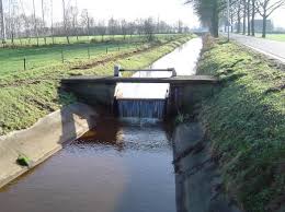
Leerinkbeek is | |Project summary=The Leerinkbeek water body is classified as a river under the WFD system. It is an R5 category water body: slow-flowing middle/lower reach on sand. The entire Leerinkbeek is managed by water authority Rijn en IJssel. The water body is located in the province of Gelderland, municipality Berkelland. It is 8,4 km long and has a catchment of 4051 hectares. The water body consists of a single channel. The water body originates in the Hupselse Beek, near the loam pits at Zwilbrock. The Leerinkbeek discharges into the Berkel. Water levels in the Leerinkbeek are managed with six adjustable weirs. None of these weirs are passable for fish. In the Leerinkbeek water body, a single maximum water level is pursued for each managed stretch, for which the weirs are used. In dry periods, the 44 upstream stretches of the water body run dry. There are no sewage treatment plants present in the catchment of the Leerinkbeek. | ||
Gelderland | |||
8,4 | Five bundles were introduced over the full width of the stream. This was mainly done as an experiment with the introduction of dead wood in streams. | ||
|Monitoring surveys and results=The bundles of branches got clogged and started to cause backwater effects. Therefore, they were replaced with coarser material, which did not cover the full width of the stream. This had a positive effect on macroinvertebrates and created more variation in structure. | |||
Leerinkbeek | |||
|Project title=Beekherstel Leerinkbeek | |Project title=Beekherstel Leerinkbeek | ||
}} | }} | ||
| Line 38: | Line 33: | ||
{{Site | {{Site | ||
|Name=Leerinkbeek | |Name=Leerinkbeek | ||
|WFD water body code=NL07_0019 | |||
|WFD (national) typology=R5, | |WFD (national) typology=R5, | ||
|Pre-project morphology=Sterk veranderend | |Pre-project morphology=Sterk veranderend | ||
| Line 53: | Line 49: | ||
|Mean discharge category=1 - 10 m³/s | |Mean discharge category=1 - 10 m³/s | ||
|Mn discharge=3.7 | |Mn discharge=3.7 | ||
|Average channel gradient category= | |Average channel gradient category=0.001 - 0.01 | ||
|Avrg channel gradient= | |Avrg channel gradient=0.0016 | ||
}} | }} | ||
{{Project background | {{Project background | ||
|Project started=2007/2015 | |||
|Project started=2015 | |||
|Works completed=2015/12/31 | |Works completed=2015/12/31 | ||
}} | }} | ||
Latest revision as of 11:43, 30 March 2021
Project overview
| Status | Complete |
|---|---|
| Project web site | |
| Themes | Flood risk management, Habitat and biodiversity, Monitoring |
| Country | Netherlands |
| Main contact forename | John |
| Main contact surname | Lenssen |
| Main contact user ID | |
| Contact organisation | Waterschap Rijn en Ijssel |
| Contact organisation web site | http://www.wrij.nl/ |
| Partner organisations | STOWA |
| Parent multi-site project | |
| This is a parent project encompassing the following projects |
No |
Project summary
The Leerinkbeek water body is classified as a river under the WFD system. It is an R5 category water body: slow-flowing middle/lower reach on sand. The entire Leerinkbeek is managed by water authority Rijn en IJssel. The water body is located in the province of Gelderland, municipality Berkelland. It is 8,4 km long and has a catchment of 4051 hectares. The water body consists of a single channel. The water body originates in the Hupselse Beek, near the loam pits at Zwilbrock. The Leerinkbeek discharges into the Berkel. Water levels in the Leerinkbeek are managed with six adjustable weirs. None of these weirs are passable for fish. In the Leerinkbeek water body, a single maximum water level is pursued for each managed stretch, for which the weirs are used. In dry periods, the 44 upstream stretches of the water body run dry. There are no sewage treatment plants present in the catchment of the Leerinkbeek.
Five bundles were introduced over the full width of the stream. This was mainly done as an experiment with the introduction of dead wood in streams.
Monitoring surveys and results
The bundles of branches got clogged and started to cause backwater effects. Therefore, they were replaced with coarser material, which did not cover the full width of the stream. This had a positive effect on macroinvertebrates and created more variation in structure.
Lessons learnt
Image gallery
|
Catchment and subcatchmentSelect a catchment/subcatchment
Catchment
Subcatchment
Other case studies in this subcatchment: Beekherstel Eefsebeek, Beekherstel Ramsbeek, Beekherstel Willinkbeek, Beneden-Berkel, Boldersbeek
Site
Project background
Cost for project phases
Reasons for river restoration
Measures
MonitoringHydromorphological quality elements
Biological quality elements
Physico-chemical quality elements
Any other monitoring, e.g. social, economic
Monitoring documents
Additional documents and videos
Additional links and references
Supplementary InformationEdit Supplementary Information
| ||||||||||||||||||||||||||||||||||||||||||||||||||||||||||||||||||||||||||||||||||||||||||||||||||||||||||||||||||||||||||||||||||||||||||||||||||||||||||||||||||||||||||||||||||||||||||||||||||||||||||||||||||||||||||||||||||||||||||||||||||||||||||||||||||||||||||||||

