Case study:Welton Farm Landfill/Riverbank Works: Difference between revisions
Crchalmers (talk | contribs) No edit summary |
Crchalmers (talk | contribs) No edit summary |
||
| (17 intermediate revisions by the same user not shown) | |||
| Line 13: | Line 13: | ||
|Contact organisation=PKC | |Contact organisation=PKC | ||
|Multi-site=No | |Multi-site=No | ||
|Project summary=The River Ericht is part of the wider Tay catchment and has a steep, flashy catchment with an area of 432km2 to its confluence with the River Tay. The project was located 2km downstream of Blairgowrie, Scotland and located within a Special Area of Conservation (SAC), UK0030312. The project was undertaken on a historic landfill site on the south riverbank of the River Ericht. There is considerable ecological variety in the Tay catchment, resulting in the Tay supporting the full range of salmon life-history types found in Scotland, with adult salmon entering the River Tay throughout the year to spawn in different parts of the catchment. In addition, Otter, Beaver, Bird and three Lamprey species (Sea, Brook and River) were found within the SAC. | |Project summary=The River Ericht is part of the wider Tay catchment and has a steep, flashy catchment with an area of 432km2 to its confluence with the River Isla which later joins the River Tay. The project was located 2km downstream of Blairgowrie, Scotland and located within a Special Area of Conservation (SAC), UK0030312. The project was undertaken on a historic landfill site on the south riverbank of the River Ericht. There is considerable ecological variety in the Tay catchment, resulting in the Tay supporting the full range of salmon life-history types found in Scotland, with adult salmon entering the River Tay throughout the year to spawn in different parts of the catchment. In addition, Otter, Beaver, Bird and three Lamprey species (Sea, Brook and River) were found within the SAC. | ||
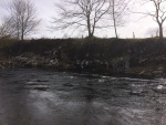
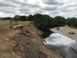
The project consisted of landfill and riverbank remediation work. Landfill material was polluting the River Ericht impacting the watercourse and subsequent SAC following numerous spate events in 2015/16. This had a direct impact upon the ecology and environment. The aim of the project was to prevent further landfill material entering the watercourse and to install protective measures to protect the riverbank and reduce further erosion. | The project consisted of landfill and riverbank remediation work. Landfill material was polluting the River Ericht impacting the watercourse and subsequent SAC following numerous spate events in 2015/16. This had a direct impact upon the ecology and environment. The aim of the project was to prevent further landfill material entering the watercourse and to install protective measures to protect the riverbank and reduce further erosion. | ||
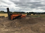
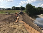
The project consisted of excavating 1800m3 of earth equating to approximately 3000 tonnes. The earth was put into a trommel where the landfill material was separated from the earth. The clean earth was used to re-profile the embankment and the landfill material sent to a recycling centre. The waste generated was approx. 50 tonnes; upwards of 97% was recycled. The waste consisted of timber, plastic, metal and green waste. Timber was shredded and used fuel (100% diverted from landfill), green waste was put into anaerobic digestion and turned into electricity and/or mixed with food waste to make compost (100% diverted from landfill) and general waste was handpicked and recycled (approx. 97% - 100% diverted from landfill). This is well within the targets set out within Scotland’s Zero Waste Plan which aims at 70% waste to be recycled and maximum 5% to landfill by 2025. | |||
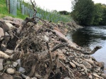
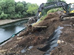
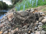
A number of non-structural green measures were implemented to stabilise the riverbank and reduce erosion. These include root wads, coir matting, planting live willow and sowing grass seed. A number of trees were removed as part of the site clearance process. These were set aside and later installed as and installed into the embankment and anchored with rock armour. Root wads were installed from upstream to downstream and spaced along riverbank at 5m intervals. | |||
Root wads were installed on the outer bend of the River Ericht; this will help to absorb and distribute the energy from the river, reducing the erosive potential. Scour pools are predicted to form at the base of the root wad which can lead to reduced flow velocities enabling bankside habitats to form. Variation of the watercourse will increase by changing the temperature and oxygen levels across its cross sectional area. The creation of riffles, pools and shaded areas benefit the macro-invertebrate population and help to improve water quality, vital for maintaining the interaction of species protected within the SAC. | |||
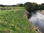
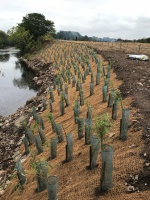
The new embankment was installed with biodegradable coir matting; this increases surface cover and generates roughness, key properties in controlling soil erosion. The coir matting was anchored to the embankment using FSC (sustainably sourced) timber stakes. A hedgerow grass seed mix was sown into the coir matting; this provides a diverse plant assemblage (native grass & wildflower) promoting plant diversity. This attracts insects and invertebrates including bees and butterflies; a step to provide habitats for species which are in national decline due to habitat loss. This supports the action plan set out in the Tayside Local Biodiversity Action Plan (2016-2026). | |||
Live Osier willow was planted at 1m2 intervals, this introduces a root network which will help to stabilise the embankment. Willow provides habitat for flora and fauna, creating shading of riverbanks and spawning areas. Willow also promotes bank stabilisation, protects the aquatic environment from polluted surface runoff and improves soil chemistry by increasing humus formation. Fourteen trees were removed as part of the site clearance. As part of my sustainable environmental approach, I replanted twenty trees to replace the habitats lost and achieve net biodiversity gain. Hawthorn and Crab Apple were planted; this benefits pollinators such as honey, bumble and solitary bee species, together with moths and butterflies. Fruits are eaten by birds and mammal and are an important resource for migrant birds. A recent review of UK biodiversity (Natural Ecosystem Assessment) states that 40% of our most important habitats and 30% of rarest species are still in decline. | |||
|Monitoring surveys and results=The project has only recently been completed and the full benefits have yet to be quantified. The willow and grass seed has started to grow following a mild autumn in 2018 and the integrity of the riverbank has been tested following a number of spate events in December 2018 and February/March 2019. A monitoring regime has been set up in order to assess the longer term performance of the scheme. | |Monitoring surveys and results=The project has only recently been completed and the full benefits have yet to be quantified. The willow and grass seed has started to grow following a mild autumn in 2018 and the integrity of the riverbank has been tested following a number of spate events in December 2018 and February/March 2019. A monitoring regime has been set up in order to assess the longer term performance of the scheme. | ||
|Lessons learn=Firmly secure willow tubing; approx. 5% lost during spate event. | |||
Willow whips to be planted from Autumn - early spring. Willow pots installed thereafter. | |||
Waste to be protected by netting to prevent windblown pollution. | |||
|Project title=Welton Farm Landfill/Riverbank Works | |Project title=Welton Farm Landfill/Riverbank Works | ||
}} | }} | ||
{{Image gallery}} | {{Image gallery}} | ||
{{Case study image | |||
|File name=Landfill.jpg | |||
|Caption=Historic Landfill | |||
}} | |||
{{Case study image | |||
|File name=Root Wad.jpg | |||
|Caption=Root Wad Installation | |||
}} | |||
{{Case study image | |||
|File name=Completion.jpg | |||
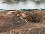
|Caption=Project Completion | |||
}} | |||
{{Case study image | |||
|File name=Drone.png | |||
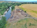
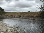
|Caption=Drone Image Following Works | |||
}} | |||
{{Case study image | |||
|File name=Reprofiling works.jpg | |||
|Caption=Repfrofiling | |||
}} | |||
{{Case study image | |||
|File name=Trommel1.PNG | |||
|Caption=Separation of waste | |||
}} | |||
{{Case study image | |||
|File name=Trommel.jpg | |||
|Caption=Separation of waste | |||
}} | |||
{{Case study image | |||
|File name=Root wad placement.JPG | |||
|Caption=root wad placement | |||
}} | |||
{{Case study image | |||
|File name=Root wad placement2.JPG | |||
|Caption=root wad placement | |||
}} | |||
{{Case study image | |||
|File name=Drone during.jpg | |||
|Caption=Drone during works | |||
}} | |||
{{Case study image | |||
|File name=Drone during 2.jpg | |||
|Caption=Drone during works | |||
}} | |||
{{Case study image | |||
|File name=Coir matting with trench.jpg | |||
|Caption=Coir matting with trench | |||
}} | |||
{{Case study image | |||
|File name=Willows.jpg | |||
|Caption=willow installation | |||
}} | |||
{{Case study image | |||
|File name=Root wad2.JPG | |||
|Caption=Root wad | |||
}} | |||
{{Case study image | |||
|File name=Completion1.jpg | |||
|Caption=Completion | |||
}} | |||
{{Image gallery end}} | {{Image gallery end}} | ||
{{Toggle button}} | {{Toggle button}} | ||
{{Toggle content start}} | {{Toggle content start}} | ||
{{Case study subcatchment}} | {{Case study subcatchment | ||
{{Site}} | |Subcatchment=River Ericht | ||
{{Project background}} | }} | ||
{{Site | |||
|Name=River Ericht | |||
|WFD water body code=6535 | |||
|WFD water body name=River Ericht | |||
|Pre-project morphology=Sinuous, | |||
|Desired post project morphology=Reinforced banks, | |||
|Heavily modified water body=No | |||
|Site designation=EU - Special Area of Conservation | |||
|Local site designation=Special Area of Conservation, | |||
|Protected species present=Yes | |||
|Invasive species present=No | |||
|Species=Otter (Lutra lutra), Atlantic salmon (Salmo salar), Sea lamprey, Brook lamprey, river lamprey, Beaver, badger, sand martin (Riparia riparia), yellow hammer | |||
|Dominant substrate=Glacial Till, Boulders, Glaciofluvial, Alluvium, Gravel, | |||
|River corridor land use=Intensive agriculture (arable), | |||
|Average bankfull channel width category=5 - 10 m | |||
|Average bankfull channel depth category=0.5 - 2 m | |||
|Mean discharge category=100 - 1000 m³/s | |||
|Mn discharge=187m³ | |||
|Average channel gradient category=Less than 0.001 | |||
|Avrg channel gradient=0.0083 | |||
}} | |||
{{Project background | |||
|Reach length directly affected=50m | |||
|Project started=01/04/2017 | |||
|Works started=2018/07/02 | |||
|Works completed=2018/08/08 | |||
|Project completed=2019/08/09 | |||
|Total cost category=50 - 100 k€ | |||
|Total1 cost=80000 | |||
|Funding sources=Local Authorities, Scottish Government, | |||
|Investigation and design Lead organisation=Perth and Kinross Council | |||
|Stakeholder engagement Lead organisation=Perth and Kinross Council | |||
|Works and supervision Lead organisation=Perth and Kinross Council | |||
|Post-project management and maintenance Lead organisation=Perth and Kinross Council | |||
|Monitoring Lead organisation=Perth and Kinross Council | |||
}} | |||
{{Motivations}} | {{Motivations}} | ||
{{Measures}} | {{Measures}} | ||
Latest revision as of 10:22, 21 March 2019
This case study is pending approval by a RiverWiki administrator.
Project overview
| Status | Complete |
|---|---|
| Project web site | |
| Themes | Environmental flows and water resources, Flood risk management, Habitat and biodiversity |
| Country | Scotland |
| Main contact forename | Chris |
| Main contact surname | Chalmers |
| Main contact user ID | |
| Contact organisation | PKC |
| Contact organisation web site | |
| Partner organisations | |
| Parent multi-site project | |
| This is a parent project encompassing the following projects |
No |
Project summary
The River Ericht is part of the wider Tay catchment and has a steep, flashy catchment with an area of 432km2 to its confluence with the River Isla which later joins the River Tay. The project was located 2km downstream of Blairgowrie, Scotland and located within a Special Area of Conservation (SAC), UK0030312. The project was undertaken on a historic landfill site on the south riverbank of the River Ericht. There is considerable ecological variety in the Tay catchment, resulting in the Tay supporting the full range of salmon life-history types found in Scotland, with adult salmon entering the River Tay throughout the year to spawn in different parts of the catchment. In addition, Otter, Beaver, Bird and three Lamprey species (Sea, Brook and River) were found within the SAC.
The project consisted of landfill and riverbank remediation work. Landfill material was polluting the River Ericht impacting the watercourse and subsequent SAC following numerous spate events in 2015/16. This had a direct impact upon the ecology and environment. The aim of the project was to prevent further landfill material entering the watercourse and to install protective measures to protect the riverbank and reduce further erosion. The project consisted of excavating 1800m3 of earth equating to approximately 3000 tonnes. The earth was put into a trommel where the landfill material was separated from the earth. The clean earth was used to re-profile the embankment and the landfill material sent to a recycling centre. The waste generated was approx. 50 tonnes; upwards of 97% was recycled. The waste consisted of timber, plastic, metal and green waste. Timber was shredded and used fuel (100% diverted from landfill), green waste was put into anaerobic digestion and turned into electricity and/or mixed with food waste to make compost (100% diverted from landfill) and general waste was handpicked and recycled (approx. 97% - 100% diverted from landfill). This is well within the targets set out within Scotland’s Zero Waste Plan which aims at 70% waste to be recycled and maximum 5% to landfill by 2025.
A number of non-structural green measures were implemented to stabilise the riverbank and reduce erosion. These include root wads, coir matting, planting live willow and sowing grass seed. A number of trees were removed as part of the site clearance process. These were set aside and later installed as and installed into the embankment and anchored with rock armour. Root wads were installed from upstream to downstream and spaced along riverbank at 5m intervals.
Root wads were installed on the outer bend of the River Ericht; this will help to absorb and distribute the energy from the river, reducing the erosive potential. Scour pools are predicted to form at the base of the root wad which can lead to reduced flow velocities enabling bankside habitats to form. Variation of the watercourse will increase by changing the temperature and oxygen levels across its cross sectional area. The creation of riffles, pools and shaded areas benefit the macro-invertebrate population and help to improve water quality, vital for maintaining the interaction of species protected within the SAC.
The new embankment was installed with biodegradable coir matting; this increases surface cover and generates roughness, key properties in controlling soil erosion. The coir matting was anchored to the embankment using FSC (sustainably sourced) timber stakes. A hedgerow grass seed mix was sown into the coir matting; this provides a diverse plant assemblage (native grass & wildflower) promoting plant diversity. This attracts insects and invertebrates including bees and butterflies; a step to provide habitats for species which are in national decline due to habitat loss. This supports the action plan set out in the Tayside Local Biodiversity Action Plan (2016-2026).
Live Osier willow was planted at 1m2 intervals, this introduces a root network which will help to stabilise the embankment. Willow provides habitat for flora and fauna, creating shading of riverbanks and spawning areas. Willow also promotes bank stabilisation, protects the aquatic environment from polluted surface runoff and improves soil chemistry by increasing humus formation. Fourteen trees were removed as part of the site clearance. As part of my sustainable environmental approach, I replanted twenty trees to replace the habitats lost and achieve net biodiversity gain. Hawthorn and Crab Apple were planted; this benefits pollinators such as honey, bumble and solitary bee species, together with moths and butterflies. Fruits are eaten by birds and mammal and are an important resource for migrant birds. A recent review of UK biodiversity (Natural Ecosystem Assessment) states that 40% of our most important habitats and 30% of rarest species are still in decline.
Monitoring surveys and results
The project has only recently been completed and the full benefits have yet to be quantified. The willow and grass seed has started to grow following a mild autumn in 2018 and the integrity of the riverbank has been tested following a number of spate events in December 2018 and February/March 2019. A monitoring regime has been set up in order to assess the longer term performance of the scheme.
Lessons learnt
Firmly secure willow tubing; approx. 5% lost during spate event.
Willow whips to be planted from Autumn - early spring. Willow pots installed thereafter.
Waste to be protected by netting to prevent windblown pollution.
Image gallery
|
Catchment and subcatchmentSelect a catchment/subcatchment
Catchment
Subcatchment
Site
Project background
Cost for project phases
Reasons for river restoration
Measures
MonitoringHydromorphological quality elements
Biological quality elements
Physico-chemical quality elements
Any other monitoring, e.g. social, economic
Monitoring documents
Additional documents and videos
Additional links and references
Supplementary InformationEdit Supplementary Information
| ||||||||||||||||||||||||||||||||||||||||||||||||||||||||||||||||||||||||||||||||||||||||||||||||||||||||||||||||||||||||||||||||||||||||||||||||||||||||||||||||||||||||||||||||||||||||||||||||||||||||

