Case study:Dunruchan Farm Peatland Restoration Project: Difference between revisions
(Created page with "{{Case study status |Approval status=Draft }} {{Location |Location=56.3060626, -3.961188600000014 }} {{Project overview |Project title=Dunruchan Farm Peatland Restoration Proj...") |
No edit summary |
||
| (5 intermediate revisions by the same user not shown) | |||
| Line 1: | Line 1: | ||
{{Case study status | {{Case study status | ||
|Approval status= | |Approval status=Approved | ||
}} | }} | ||
{{Location | {{Location | ||
| Line 6: | Line 6: | ||
}} | }} | ||
{{Project overview | {{Project overview | ||
|Status=Complete | |Status=Complete | ||
|Themes=Flood risk management, Habitat and biodiversity, Water quality | |Themes=Flood risk management, Habitat and biodiversity, Water quality | ||
| Line 14: | Line 13: | ||
|Contact organisation=River Forth Fisheries Trust | |Contact organisation=River Forth Fisheries Trust | ||
|Contact organisation url=www.fishforth.co.uk/rfft/ | |Contact organisation url=www.fishforth.co.uk/rfft/ | ||
|Partner organisations=Scottish Government, Scottish Natural Heritage, Drummond Estates, Dunruchan Farm | |||
|Multi-site=No | |Multi-site=No | ||
|Project picture=39 Dunruchan Farm.png | |||
|Project summary=The Allan Water catchment has 3 Potentially Vulnerable Areas to flood risk as determined in the National Flood Risk Assessment 2009. The scoping study for this project used hydrological modelling that identified the Knaik subcatchment as contributing on average 23% of the flood peak which occurs in the most downstream PVA in the catchment. Hillsides with fast flow pathways due to hill grips is one reason the Knaik subcatchment has such an impact on the Allan Water flood peak. The project identified an area of the Knaik subcatchment where extensive hill grips were present and work was possible. By using measures such as peat dams and wooden sediment traps, fast water conveyance was attenuated and the blanket bog habitat was restored. | |||
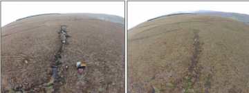
The Dunruchan Farm Peatland Restoration Project restored 48.2ha of extensively drained upland blanket bog at just under 300m altitude by using approximately 790 peat dams, 10.4km (10,365m) ditch and gully reprofiling, 6 wooden sediment traps, one 10m bund, 30m worth of in-ditch bunds and 7 plastic dams. | |||
Research opportunities to look into the impact of the project on downstream flood risk and wider ecosystem benefits are currently being investigated. The Knaik subcatchment covers 39km² while the restored area is 0.482km² (1.2%), and so the effect may only be local. If the project's impact is considered as part of a wider network of NFM measures in the Allan Water catchment, however, the cumulative impact may be more significant. | |||
|Project title=Dunruchan Farm Peatland Restoration Project | |||
}} | }} | ||
{{Image gallery}} | {{Image gallery}} | ||
| Line 21: | Line 26: | ||
{{Toggle content start}} | {{Toggle content start}} | ||
{{Case study subcatchment}} | {{Case study subcatchment}} | ||
{{Site}} | {{Site | ||
{{Project background}} | |Name=River Knaik, Allan Water | ||
{{Motivations}} | |Heavily modified water body=No | ||
{{Measures}} | |Protected species present=No | ||
|Invasive species present=No | |||
}} | |||
{{Project background | |||
|Project started=2015 | |||
|Total1 cost=£37k | |||
|Funding sources=Scottish Natural Heritage, Scottish Government, | |||
}} | |||
{{Motivations | |||
|Specific mitigation=Flood risk management, | |||
}} | |||
{{Measures | |||
|Other technical measure=Surface drainage systems improved, | |||
}} | |||
{{Hydromorphological quality elements header}} | {{Hydromorphological quality elements header}} | ||
{{End table}} | {{End table}} | ||
Latest revision as of 12:03, 8 November 2018
Project overview
| Status | Complete |
|---|---|
| Project web site | |
| Themes | Flood risk management, Habitat and biodiversity, Water quality |
| Country | Scotland |
| Main contact forename | Laurence |
| Main contact surname | Belleni |
| Main contact user ID | |
| Contact organisation | River Forth Fisheries Trust |
| Contact organisation web site | http://www.fishforth.co.uk/rfft/ |
| Partner organisations | Scottish Government, Scottish Natural Heritage, Drummond Estates, Dunruchan Farm |
| Parent multi-site project | |
| This is a parent project encompassing the following projects |
No |
Project summary
The Allan Water catchment has 3 Potentially Vulnerable Areas to flood risk as determined in the National Flood Risk Assessment 2009. The scoping study for this project used hydrological modelling that identified the Knaik subcatchment as contributing on average 23% of the flood peak which occurs in the most downstream PVA in the catchment. Hillsides with fast flow pathways due to hill grips is one reason the Knaik subcatchment has such an impact on the Allan Water flood peak. The project identified an area of the Knaik subcatchment where extensive hill grips were present and work was possible. By using measures such as peat dams and wooden sediment traps, fast water conveyance was attenuated and the blanket bog habitat was restored.
The Dunruchan Farm Peatland Restoration Project restored 48.2ha of extensively drained upland blanket bog at just under 300m altitude by using approximately 790 peat dams, 10.4km (10,365m) ditch and gully reprofiling, 6 wooden sediment traps, one 10m bund, 30m worth of in-ditch bunds and 7 plastic dams.
Research opportunities to look into the impact of the project on downstream flood risk and wider ecosystem benefits are currently being investigated. The Knaik subcatchment covers 39km² while the restored area is 0.482km² (1.2%), and so the effect may only be local. If the project's impact is considered as part of a wider network of NFM measures in the Allan Water catchment, however, the cumulative impact may be more significant.
Monitoring surveys and results
Lessons learnt
Image gallery
|
Catchment and subcatchment
Site
Project background
Cost for project phases
Reasons for river restoration
Measures
MonitoringHydromorphological quality elements
Biological quality elements
Physico-chemical quality elements
Any other monitoring, e.g. social, economic
Monitoring documents
Additional documents and videos
Additional links and references
Supplementary InformationEdit Supplementary Information
| ||||||||||||||||||||||||||||||||||||||||||||||||||||||||||||||||||||||||||||||||||||||||||||||||||||||||||||||||||||||||||||||||||||||||||||||||||||||||||||||||||||||||||||||||||

