Case study:Elgin Flood Alleviation Scheme: Difference between revisions
No edit summary |
No edit summary |
||
| (20 intermediate revisions by 3 users not shown) | |||
| Line 1: | Line 1: | ||
{{Case study status | {{Case study status | ||
|Approval status= | |Approval status=Approved | ||
}} | }} | ||
{{Location | {{Location | ||
| Line 7: | Line 7: | ||
{{Project overview | {{Project overview | ||
|Status=In progress | |Status=In progress | ||
|Project web site url=www.moray.gov.uk/moray_standard/page_81702.html | |||
|Themes=Economic aspects, Fisheries, Flood risk management, Habitat and biodiversity, Hydromorphology, Monitoring, Social benefits, Water quality, Urban | |Themes=Economic aspects, Fisheries, Flood risk management, Habitat and biodiversity, Hydromorphology, Monitoring, Social benefits, Water quality, Urban | ||
|Country=Scotland | |Country=Scotland | ||
| Line 14: | Line 15: | ||
|Contact organisation=Royal HaskoningDHV | |Contact organisation=Royal HaskoningDHV | ||
|Contact organisation url=www.royalhaskoningdhv.com/ | |Contact organisation url=www.royalhaskoningdhv.com/ | ||
|Partner organisations=The Moray Council, Morrison Construction, E C Harris, SEPA, Scottish Natural Heritage, Historic Scotland, Scottish Agricultural College, Findhorn Nairn and Lossie Fisheries Trust | |||
|Multi-site=No | |Multi-site=No | ||
|Project picture=TL comp.jpg | |||
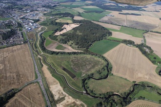
|Picture description=Tyock and Linkwood Burn aerial photograph - September 2014 © Royal HaskoningDHV | |||
|Project summary=<p>Elgin, one of Scotland’s oldest towns, has developed along the banks of the River Lossie for over 900 years. The River Lossie drains an area of approximately 270km² to the sea at Lossiemouth. Flooding in Elgin is not a new problem. Around twenty flood events have been recorded since 1750, with 11 floods in the last 50 years. Most recently Elgin flooded in 1997, 2000, 2002, 2009 and 2014.</p> | |Project summary=<p>Elgin, one of Scotland’s oldest towns, has developed along the banks of the River Lossie for over 900 years. The River Lossie drains an area of approximately 270km² to the sea at Lossiemouth. Flooding in Elgin is not a new problem. Around twenty flood events have been recorded since 1750, with 11 floods in the last 50 years. Most recently Elgin flooded in 1997, 2000, 2002, 2009 and 2014.</p> | ||
<p>Until recently, during major flood events, key transport links that serve the north east of Scotland have been severed. In 1997 and 2002, the A96 trunk road was closed for more than 48 hours, whilst the Inverness to Aberdeen railway line suffered considerable damage and was closed for several weeks. Flooding has caused great disruption and distress to the community of Elgin. In 2002 over 200 households were evacuated and 10 people had to be airlifted to safety; while the number of flooded homes and businesses was substantially greater.</p> | <p>Until recently, during major flood events, key transport links that serve the north east of Scotland have been severed. In 1997 and 2002, the A96 trunk road was closed for more than 48 hours, whilst the Inverness to Aberdeen railway line suffered considerable damage and was closed for several weeks. Flooding has caused great disruption and distress to the community of Elgin. In 2002 over 200 households were evacuated and 10 people had to be airlifted to safety; while the number of flooded homes and businesses was substantially greater.</p> | ||
| Line 24: | Line 28: | ||
• Setting back flood embankments and flood walls from Glen Moray Distillery in the west to the new confluence of the Tyock/Linkwood diversion channel with the River Lossie in the east.<br> | • Setting back flood embankments and flood walls from Glen Moray Distillery in the west to the new confluence of the Tyock/Linkwood diversion channel with the River Lossie in the east.<br> | ||
• Replacement and construction of three bridges to increase flood resilience and improve access. The innovative Landshut Bridge was designed within the historic context of the area surrounding Elgin Cathedral and Pans Port providing an understated structure with high architectural merit. | • Replacement and construction of three bridges to increase flood resilience and improve access. The innovative Landshut Bridge was designed within the historic context of the area surrounding Elgin Cathedral and Pans Port providing an understated structure with high architectural merit. | ||
|Monitoring surveys and results= | |Monitoring surveys and results=Integrated and science-based monitoring has illustrated positive change over the course of the project. Baseline geomorphology, ecology, and water chemistry surveying and repeat surveys during construction within and adjacent to the scheme footprint have enabled the design of the scheme to progress in a way which protects the existing characteristics of the area.</p> | ||
<p>The scheme monitoring includes:<br> | |||
• Geomorphological surveys identified areas where bank protection was required and on-going monitoring will be undertaken to ensure that erosion is mitigated.<br> | • Geomorphological surveys identified areas where bank protection was required and on-going monitoring will be undertaken to ensure that erosion is mitigated.<br> | ||
• Water chemistry sampling has proven that the water treatment feature has been successful in removing dieldrin from the Tyock Burn.<br> | • Water chemistry sampling has proven that the water treatment feature has been successful in removing dieldrin from the Tyock Burn.<br> | ||
| Line 31: | Line 36: | ||
• Bat and bird boxes will continue to be monitored and maintained as required.<br> | • Bat and bird boxes will continue to be monitored and maintained as required.<br> | ||
• Aerial surveys will continue into the future to undertake wide scale assessments. | • Aerial surveys will continue into the future to undertake wide scale assessments. | ||
|Lessons learn= | |Lessons learn=The same integrated project team has worked on five separate flood alleviation schemes protecting four communities in Moray under the banner of Moray Flood Alleviation. These schemes represent an investment totaling £180 million over a fifteen year period. This has been key to the success of the project.</p> | ||
<p>The project team operates a “continuous improvement” philosophy, using regular lessons learnt workshops to ensure that time and money is not wasted on avoidable mistakes in the future. Over the course of the project the team has developed a collaborative and efficient way of working. Currently the project is set to come in £10 million below budget. Four of the five schemes have been completed on time with Elgin scheduled to finish on time this year, 15 years after the start of the project. The project team has been co-located in the same open plan office throughout the scheme’s development and delivery ensuring matters are discussed easily and decisions are made quickly.</p> | <p>The project team operates a “continuous improvement” philosophy, using regular lessons learnt workshops to ensure that time and money is not wasted on avoidable mistakes in the future. Over the course of the project the team has developed a collaborative and efficient way of working. Currently the project is set to come in £10 million below budget. Four of the five schemes have been completed on time with Elgin scheduled to finish on time this year, 15 years after the start of the project. The project team has been co-located in the same open plan office throughout the scheme’s development and delivery ensuring matters are discussed easily and decisions are made quickly.</p> | ||
| Line 45: | Line 50: | ||
}} | }} | ||
{{Image gallery}} | {{Image gallery}} | ||
{{Case study image | |||
|File name=Pansport comp aerial.jpg | |||
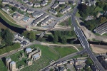
|Caption=Pansport Bridge aerial photograph - September 2014 © Royal HaskoningDHV | |||
}} | |||
{{Case study image | |||
|File name=Construction of Pansport Bridge.jpg | |||
|Caption=Construction of Pansport Bridge © Royal HaskoningDHV | |||
}} | |||
{{Case study image | |||
|File name=River Engineering Channel.jpg | |||
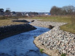
|Caption=Necessary bank protection works © Royal HaskoningDHV | |||
}} | |||
{{Case study image | |||
|File name=River Engineering Culvert.jpg | |||
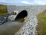
|Caption=New river infrastructure © Royal HaskoningDHV | |||
}} | |||
{{Image gallery end}} | {{Image gallery end}} | ||
{{Toggle button}} | {{Toggle button}} | ||
| Line 50: | Line 71: | ||
{{Case study subcatchment}} | {{Case study subcatchment}} | ||
{{Site}} | {{Site}} | ||
{{Project background}} | {{Project background | ||
{{Motivations}} | |Project started=2005/01/01 | ||
{{Measures}} | |Total cost category=more than 10000 k€ | ||
|Total1 cost=83500 | |||
}} | |||
{{Motivations | |||
|Specific mitigation=Flood risk management, Flood and coastal erosion protection, | |||
|Hydromorphological quality elements=Quantity & dynamics of flow, Continuity of sediment transport, Channel pattern/planform, Width & depth variation, Substrate conditions, | |||
|Biological quality elements=Fish, Invertebrates, Macrophytes, | |||
|Physico-chemical quality elements=Nutrient concentrations, Oxygen balance, Transparency, | |||
|Other motivation=Multiple reasons - see Project Summary | |||
}} | |||
{{Measures | |||
|Bank and bed modifications measure=Bank improvement, Channel reprofiling, Creation of berms, Depth variation, | |||
|Floodplain / River corridor=Lowering of floodplain, Creation of wetland, Removal of embankments, | |||
|Planform / Channel pattern=Creation of new channel, | |||
|Social measures=Community Education, Community consultation, | |||
}} | |||
{{Hydromorphological quality elements header}} | {{Hydromorphological quality elements header}} | ||
{{End table}} | {{End table}} | ||
Latest revision as of 13:12, 6 June 2017
Project overview
| Status | In progress |
|---|---|
| Project web site | http://www.moray.gov.uk/moray_standard/page_81702.html |
| Themes | Economic aspects, Fisheries, Flood risk management, Habitat and biodiversity, Hydromorphology, Monitoring, Social benefits, Water quality, Urban |
| Country | Scotland |
| Main contact forename | Tamzen |
| Main contact surname | Pope |
| Main contact user ID | User:Nick Elbourne |
| Contact organisation | Royal HaskoningDHV |
| Contact organisation web site | http://www.royalhaskoningdhv.com/ |
| Partner organisations | The Moray Council, Morrison Construction, E C Harris, SEPA, Scottish Natural Heritage, Historic Scotland, Scottish Agricultural College, Findhorn Nairn and Lossie Fisheries Trust |
| Parent multi-site project | |
| This is a parent project encompassing the following projects |
No |
Project summary
Elgin, one of Scotland’s oldest towns, has developed along the banks of the River Lossie for over 900 years. The River Lossie drains an area of approximately 270km² to the sea at Lossiemouth. Flooding in Elgin is not a new problem. Around twenty flood events have been recorded since 1750, with 11 floods in the last 50 years. Most recently Elgin flooded in 1997, 2000, 2002, 2009 and 2014.
Until recently, during major flood events, key transport links that serve the north east of Scotland have been severed. In 1997 and 2002, the A96 trunk road was closed for more than 48 hours, whilst the Inverness to Aberdeen railway line suffered considerable damage and was closed for several weeks. Flooding has caused great disruption and distress to the community of Elgin. In 2002 over 200 households were evacuated and 10 people had to be airlifted to safety; while the number of flooded homes and businesses was substantially greater.
The Elgin Flood Alleviation Scheme (FAS) is the single largest to be promoted in Scotland to date. The scheme is designed to provide a current-day standard of defence of 1 in 200 years. The preferred scheme for Elgin was selected on 25 February 2004. A Flood Prevention Order was publicised in October 2007 and a planning application submitted in January 2008. Scottish Ministers confirmed the scheme in December 2010, with construction starting in April 2011. Construction is due to complete in 2015. The scheme protects around 750 residential properties and 250 businesses.
The scheme includes:
• The restoration of an expansive blue/green corridor through Elgin reflecting both the historic and natural setting of the watercourse.
• The creation of a two-stage channel within the flood corridor, through the centre of the town, by floodplain lowering allowing flood flows to pass safely through Elgin.
• The creation of a new flood relief channel opposite Elgin Cathedral and a new natural channel to move the Tyock confluence approximately 1.5km downstream to address flood risk in New Elgin.
• Setting back flood embankments and flood walls from Glen Moray Distillery in the west to the new confluence of the Tyock/Linkwood diversion channel with the River Lossie in the east.
• Replacement and construction of three bridges to increase flood resilience and improve access. The innovative Landshut Bridge was designed within the historic context of the area surrounding Elgin Cathedral and Pans Port providing an understated structure with high architectural merit.
Monitoring surveys and results
The scheme monitoring includes:
• Geomorphological surveys identified areas where bank protection was required and on-going monitoring will be undertaken to ensure that erosion is mitigated.
• Water chemistry sampling has proven that the water treatment feature has been successful in removing dieldrin from the Tyock Burn.
• Continued monitoring of the newly established areas of wetland, riparian and wildflower meadow planting will be required to ensure that these biodiverse habitats flourish.
• Large areas of giant hogweed and Japanese knotweed have been treated over the past seven years. On-going monitoring and action will be required to ensure that these do not return to the area.
• Bat and bird boxes will continue to be monitored and maintained as required.
• Aerial surveys will continue into the future to undertake wide scale assessments.
Lessons learnt
The same integrated project team has worked on five separate flood alleviation schemes protecting four communities in Moray under the banner of Moray Flood Alleviation. These schemes represent an investment totaling £180 million over a fifteen year period. This has been key to the success of the project.
The project team operates a “continuous improvement” philosophy, using regular lessons learnt workshops to ensure that time and money is not wasted on avoidable mistakes in the future. Over the course of the project the team has developed a collaborative and efficient way of working. Currently the project is set to come in £10 million below budget. Four of the five schemes have been completed on time with Elgin scheduled to finish on time this year, 15 years after the start of the project. The project team has been co-located in the same open plan office throughout the scheme’s development and delivery ensuring matters are discussed easily and decisions are made quickly.
During the development of the design for the scheme, the implementation of the Water Framework Directive was in its infancy. Working closely with SEPA, the team were able to predict the implications of the Directive and design a scheme which complemented the requirements. Meeting with SEPA on a monthly basis has resulted in a sound relationship where issues have been discussed and resolved promptly.
The Elgin scheme has been shortlisted for the ACE/NCE 2015 Outstanding Achievement Award, which recognises schemes that have made a contribution to the reputation of consultancy and engineering. The team has also twice been commended by The Saltire Society at their Awards for Civil Engineering; in 2010 for the Forres FAS for a “well managed and well executed FAS, constructed with high regard for the environment”, and in 2012 for the Rothes FAS for “the co-operation, goodwill and ingenuity demonstrated by the team, coupled with the response elicited from the community.”
“In more ways than one our community has been given a new lease of life and features have been created that complement the authentic architecture and public face of our village.”
Rev Bob Anderson, Rothes Parish Minister
“I challenged the team to deliver flood alleviation and complement the environment. My measure of success was that the Scheme should be “invisible” and prevent flooding. Not only was the challenge met, but the Scheme was delivered ahead of programme and under budget. The team excelled and the outcome is very pleasing.”
Peter Haslam, Moray Council
Image gallery
|
Catchment and subcatchment
Site
Project background
Cost for project phases
Reasons for river restoration
Measures
MonitoringHydromorphological quality elements
Biological quality elements
Physico-chemical quality elements
Any other monitoring, e.g. social, economic
Monitoring documents
Additional documents and videos
Additional links and references
Supplementary InformationEdit Supplementary Information
| ||||||||||||||||||||||||||||||||||||||||||||||||||||||||||||||||||||||||||||||||||||||||||||||||||||||||||||||||||||||||||||||||||||||||||||||||||||||||||||||||||||||||


