Case study:Lodge Burn Flood Alleviation Scheme: Difference between revisions
Mattleeson (talk | contribs) No edit summary |
No edit summary |
||
| (12 intermediate revisions by 4 users not shown) | |||
| Line 1: | Line 1: | ||
{{Case study status | {{Case study status | ||
|Approval status= | |Approval status=Approved | ||
}} | }} | ||
{{Location | {{Location | ||
| Line 14: | Line 14: | ||
|Main contact id=NickRRC | |Main contact id=NickRRC | ||
|Contact organisation=River Restoration Centre | |Contact organisation=River Restoration Centre | ||
|Partner organisations=Atkins, Rivers Agency, McLauchlin & Harvey | |Partner organisations=Atkins, Rivers Agency Northern Ireland (DARDNI), McLauchlin & Harvey | ||
|Multi-site=No | |Multi-site=No | ||
|Project picture=P9130227 a.JPG | |Project picture=P9130227 a.JPG | ||
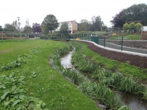
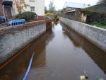
|Picture description=Restored channel in Anderson Park - site of former pond. Channel constrained by hidden gabion baskets to restrict lateral migration. Courtesy of Gareth Greer - Rivers Agency (Northern Ireland). | |Picture description=Restored channel in Anderson Park - site of former pond. Channel constrained by hidden gabion baskets to restrict lateral migration. Courtesy of Gareth Greer - Rivers Agency (Northern Ireland). | ||
|Project summary=Reports found that sections of the Lodge Burn through Coleraine flooded on a regular basis, particularly in Anderson Park and downstream of Millburn Road. A feasibility study was undertaken by Atkins to identify potential solutions to the flooding issue, which determined that a staged approach would be best for the implementation of flood alleviation works. | |Project summary=Reports found that sections of the Lodge Burn through Coleraine flooded on a regular basis, particularly in Anderson Park and downstream of Millburn Road. A feasibility study was undertaken by Atkins to identify potential solutions to the flooding issue, which determined that a staged approach would be best for the implementation of flood alleviation works. | ||
| Line 35: | Line 35: | ||
6. Diversion of large water main and supporting beam, which has been obstructing flow. | 6. Diversion of large water main and supporting beam, which has been obstructing flow. | ||
Vegetated riverbanks within flood wall (habitat enhancement). | |||
}} | |||
{{Image gallery}} | |||
{{Case study image | |||
|File name=DSC00394.jpg | |||
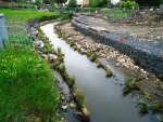
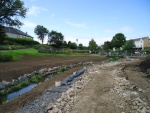
|Caption=Channel restoration in Anderson park during works. Gabion baskets installed to constrain lateral channel migration. Courtesy of Gareth Greer - Rivers Agency (Northern Ireland). See main project photo for post-restoration channel. | |||
}} | |||
{{Case study image | |||
|File name=DSC00738.jpg | |||
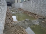
|Caption=Channel restoration in Anderson park prior to revegetation of banks. Courtesy of Rivers Agency (Northern Ireland). See main project photo for post-restoration channel. | |||
}} | |||
{{Case study image | |||
|File name=DSC01141.jpg | |||
|Caption=Channel restoration through Anderson Park, post-restoration. New channel and banks well established. Courtesy of Rivers Agency (Northern Ireland). | |||
}} | |||
{{Case study image | |||
|File name=DSC01053.jpg | |||
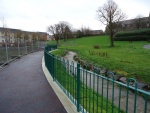
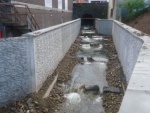
|Caption=Flood wall during construction. Courtesy of Rivers Agency (Northern Ireland). | |||
}} | |||
{{Case study image | |||
|File name=DSC09196.jpg | |||
|Caption=Rock ramp installed at outfall of Railway Road Bridge, for easement of fish passage. Courtesy of Rivers Agency (Northern Ireland). | |||
}} | |||
{{Case study image | |||
|File name=DSC09163.jpg | |||
|Caption=Rock ramp for easement of fish passage upstream - upon completion. Courtesy of Rivers Agency (Northern Ireland). | |||
}} | |||
{{Case study image | |||
|File name=DSC00235.jpg | |||
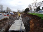
|Caption=Leisure Centre culvert in construction. Courtesy of Rivers Agency (Northern Ireland). | |||
}} | |||
{{Case study image | |||
|File name=DSC01089.jpg | |||
|Caption=Leisure Centre culvert outlet - upon completion. Courtesy of Rivers Agency (Northern Ireland). | |||
}} | }} | ||
{{Image gallery end}} | |||
{{Toggle button}} | |||
{{Toggle content start}} | |||
{{Case study subcatchment | {{Case study subcatchment | ||
|Subcatchment=River Bann | |Subcatchment=River Bann | ||
| Line 71: | Line 109: | ||
}} | }} | ||
{{Measures | {{Measures | ||
|Bank and bed modifications measure=Culvert replacement/repair, silt-trapping weir installation, | |Bank and bed modifications measure=Culvert replacement/repair, silt-trapping weir installation, habitat improvements, Rock ramp construction, Creation of fish passes, | ||
|Floodplain / River corridor= | |Floodplain / River corridor=Construction of flood wall, | ||
|Planform / Channel pattern=Removal of pond to restore natural course and sediment transport. | |Planform / Channel pattern=Removal of pond to restore natural course and sediment transport. | ||
|Other technical measure=Diversion of water main and supporting beam - obstruction to flow. | |Other technical measure=Diversion of water main and supporting beam - obstruction to flow. | ||
| Line 86: | Line 124: | ||
{{Monitoring documents}} | {{Monitoring documents}} | ||
{{Monitoring documents end}} | {{Monitoring documents end}} | ||
{{Additional Documents}} | {{Additional Documents}} | ||
{{Additional Documents end}} | {{Additional Documents end}} | ||
{{Additional links and references header}} | {{Additional links and references header}} | ||
{{Additional links and references | |||
|Link=www.lodgeburn.com/Photo_Gallery.html | |||
|Description=Project Photographs | |||
}} | |||
{{Additional links and references footer}} | {{Additional links and references footer}} | ||
{{Supplementary Information}} | {{Supplementary Information}} | ||
{{Toggle content end}} | |||
Latest revision as of 12:12, 6 June 2017
Project overview
| Status | Complete |
|---|---|
| Project web site | http://www.lodgeburn.com |
| Themes | Flood risk management |
| Country | Northern Ireland |
| Main contact forename | Nick |
| Main contact surname | Elbourne |
| Main contact user ID | User:NickRRC |
| Contact organisation | River Restoration Centre |
| Contact organisation web site | |
| Partner organisations | Atkins, Rivers Agency Northern Ireland (DARDNI), McLauchlin & Harvey |
| Parent multi-site project | |
| This is a parent project encompassing the following projects |
No |
Project summary
Reports found that sections of the Lodge Burn through Coleraine flooded on a regular basis, particularly in Anderson Park and downstream of Millburn Road. A feasibility study was undertaken by Atkins to identify potential solutions to the flooding issue, which determined that a staged approach would be best for the implementation of flood alleviation works.
Phase 1 included the implementation of measures for flood alleviation through river channel improvements, to minimise flooding to a 1 in 100 year event.
WORKS:
1. Replacement culvert constructed, with floor embedded to upstream bed level. Low flow channel through culvert, to allow fish passage during low-flow periods.
2. In-situ improvement to old masonry culvert - aligned with replacement culvert upstream to improve flow conditions.
3. Flood wall construction between Railway Road Bridge and Brook Street Bridge.
4. New vegetated riverbanks alongside floodwall, for habitat enhancement. Rock ramp pool and weir fish pass constructed at outfall of Railway Road Bridge. New spawning areas created using existing bed material, boulders and gravels.
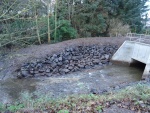
5. Removal of Anderson Park pond to restore natural course of river, facilitate free fish passage and allow for natural sediment transport to be restored.
6. Diversion of large water main and supporting beam, which has been obstructing flow.
Vegetated riverbanks within flood wall (habitat enhancement).
Monitoring surveys and results
Lessons learnt
Image gallery
|
Catchment and subcatchmentSelect a catchment/subcatchment
Catchment
Subcatchment
Other case studies in this subcatchment: Lodge Burn cascade fish pass and culvert bed restoration (as part of the Lodge Burn FAS)
Site
Project background
Cost for project phases
Reasons for river restoration
Measures
MonitoringHydromorphological quality elements
Biological quality elements
Physico-chemical quality elements
Any other monitoring, e.g. social, economic
Monitoring documents
Additional documents and videos
Additional links and references
Supplementary InformationEdit Supplementary Information
| ||||||||||||||||||||||||||||||||||||||||||||||||||||||||||||||||||||||||||||||||||||||||||||||||||||||||||||||||||||||||||||||||||||||||||||||||||||||||||||||||||||||||||||||||||||||||||||||||||||||||||

