Case study:Borova Stream and its Revitalisation: Difference between revisions
No edit summary |
No edit summary |
||
| (2 intermediate revisions by 2 users not shown) | |||
| Line 1: | Line 1: | ||
{{Case study status | {{Case study status | ||
|Approval status= | |Approval status=Approved | ||
}} | }} | ||
{{Location | {{Location | ||
| Line 55: | Line 55: | ||
}} | }} | ||
{{Measures | {{Measures | ||
|Floodplain / River corridor=Riparian | |Floodplain / River corridor=Riparian planting, | ||
|Planform / Channel pattern= | |Planform / Channel pattern=Meandering channel, | ||
}} | }} | ||
{{Hydromorphological quality elements header}} | {{Hydromorphological quality elements header}} | ||
Latest revision as of 16:35, 2 January 2019
Project overview
| Status | Complete |
|---|---|
| Project web site | |
| Themes | Flood risk management, Habitat and biodiversity |
| Country | Czech Republic |
| Main contact forename | Jan |
| Main contact surname | Flasar |
| Main contact user ID | |
| Contact organisation | Blansky Les PLA Authority |
| Contact organisation web site | http://www.ochranaprirody.cz |
| Partner organisations | |
| Parent multi-site project | |
| This is a parent project encompassing the following projects |
No |
Project summary
In the 1970s and mainly 1980s, the large scale regulation of water regime in the landscape was carried out over the whole country (at that time it was Czechoslovakia). The purpose was to increase self-sufficiency in agricultural production, which was desired by the communistic government. As a part of this effort (in many cases not cost beneficial), the water regime of Borova brook and its catchment area were also regulated.
In a large-scale drainage project (done in 1982-1984), the orginal meandering stream of the Borova brook was straightened and reduced. The stream bed was over deepened to a depth of 1.2-1.8m and stregthened by concrete blocks. At the same time, argricultural land in the catchment area (17.8 km2)of the brook was drained. The result of the intervention was a serious disturbance of the water regime in the whole catchment area and led to the degradation and decline of natural and semi-natural communities
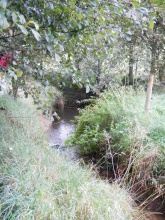
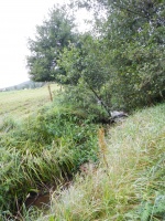
The restration was undertaken in two phases. During the restoratio the length of the stream increased by 6.3 km. A shallow meandering streambed, where sections of speedily running water alternated with sections of a slow stream were created. The project was fully funded from the program for revitalization of river systems by the minitry of Environment.
Monitoring surveys and results
Invertebrate within the wet habitats of the brook valley responded positively to the restoration. There was an increase in diversity following the works.
The stream provided flood storage during the 2001 flooding.
Lessons learnt
Image gallery
|
Catchment and subcatchment
Site
Project background
Cost for project phases
Reasons for river restoration
Measures
MonitoringHydromorphological quality elements
Biological quality elements
Physico-chemical quality elements
Any other monitoring, e.g. social, economic
Monitoring documents
Additional documents and videos
Additional links and references
Supplementary InformationEdit Supplementary Information Maradova M. (2004) Effect of streambed retsortaion on macroinvertebrates biodiversity: the case of Borova brook (landscape Potected Area Blansky les, Czech Republic). Master thesis, Faculty of Biological Sciences, University of South Bohemia.
| ||||||||||||||||||||||||||||||||||||||||||||||||||||||||||||||||||||||||||||||||||||||||||||||||||||||||||||||||||||||||||||||||||||||||||||||||||||||||||||||||||||||||||||||||||


