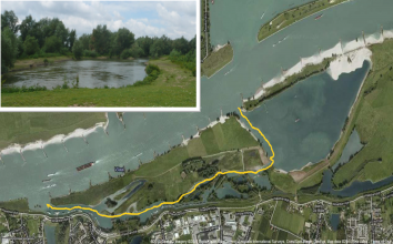
Case study:Beneden-Leeuwen-Side channel: Difference between revisions
Jump to navigation
Jump to search
No edit summary |
No edit summary |
||
| (7 intermediate revisions by 3 users not shown) | |||
| Line 1: | Line 1: | ||
{{ | {{Case study status | ||
|Approval status= | |Approval status=Approved | ||
}} | }} | ||
{{Location | {{Location | ||
| Line 22: | Line 17: | ||
|Multi-site=No | |Multi-site=No | ||
|Project picture=BLphoto.png | |Project picture=BLphoto.png | ||
|Picture description=Ecological benefits of side channels presentation, M. Schoor (2010) | |||
}} | }} | ||
{{Image_gallery}} | |||
{{Image_gallery_end}} | |||
{{Toggle button}} | |||
{{Toggle content start}} | |||
{{Case_study_subcatchment | {{Case_study_subcatchment | ||
|Subcatchment= | |Subcatchment= | ||
| Line 79: | Line 79: | ||
}} | }} | ||
{{ | {{Project background | ||
|Reach length directly affected= | |Reach length directly affected=1000 | ||
|Project started=1994/01/01 | |||
|Works started=1994/01/01 | |||
|Works completed=1997/01/01 | |||
|Project started= | |||
|Works started= | |||
|Works completed= | |||
}} | }} | ||
{{Motivations | {{Motivations | ||
| Line 166: | Line 100: | ||
}} | }} | ||
{{Measures | {{Measures | ||
|Bank and bed modifications measure= | |Bank and bed modifications measure=Bank reprofiling, | ||
|Planform / Channel pattern=Side channel created, Creation of backwater, | |||
|Management interventions=More natural water retention | |||
|Planform / Channel pattern= | |||
|Management interventions= | |||
}} | }} | ||
{{Hydromorphological_quality_elements_header}} | {{Hydromorphological_quality_elements_header}} | ||
| Line 250: | Line 171: | ||
{{Monitoring_documents}} | {{Monitoring_documents}} | ||
{{Monitoring_documents_end}} | {{Monitoring_documents_end}} | ||
{{Additional_Documents}} | {{Additional_Documents}} | ||
{{Additional_Documents_end}} | {{Additional_Documents_end}} | ||
| Line 276: | Line 195: | ||
}} | }} | ||
{{Case_study_upload}} | {{Case_study_upload}} | ||
{{Toggle content end}} | |||
Latest revision as of 16:00, 2 January 2019
Location: 51° 53' 18.60" N, 5° 31' 41.12" E
Left click to look around in the map, and use the wheel of your mouse to zoom in and out.
Project overview
| Status | Complete |
|---|---|
| Project web site | |
| Themes | Habitat and biodiversity, Monitoring, Water quality |
| Country | Netherlands |
| Main contact forename | Rogier |
| Main contact surname | Vogelij |
| Main contact user ID | |
| Contact organisation | Rijkswaterstaat |
| Contact organisation web site | |
| Partner organisations | |
| Parent multi-site project | |
| This is a parent project encompassing the following projects |
No |
Project summary
This case study hasn’t got any project summary, you can add some by editing the project overview.
Monitoring surveys and results
This case study hasn’t got any Monitoring survey and results, you can add some by editing the project overview.
Lessons learnt
This case study hasn’t got any lessons learnt, you can add some by editing the project overview.
Image gallery
|
Catchment and subcatchmentSelect a catchment/subcatchment
Catchment
Subcatchment
Other case studies in this subcatchment: Buiten Ooij, Millingerwaard-Floodplain rehabilitation, Opijnen- Side channel
Site
Project background
Cost for project phases
Reasons for river restoration
Measures
MonitoringHydromorphological quality elements
Biological quality elements
Physico-chemical quality elements
Any other monitoring, e.g. social, economic
Monitoring documents
Additional documents and videos
Additional links and references
Supplementary InformationEdit Supplementary Information
| |||||||||||||||||||||||||||||||||||||||||||||||||||||||||||||||||||||||||||||||||||||||||||||||||||||||||||||||||||||||||||||||||||||||||||||||||||||||||||||||||||||||||||||||||||||||||||||||||||||||||||||||||||

