Case study:Timber float restorations at River Iijoki: Difference between revisions
Jump to navigation
Jump to search
No edit summary |
No edit summary |
||
| (14 intermediate revisions by 4 users not shown) | |||
| Line 1: | Line 1: | ||
{{ | {{Case study status | ||
|Approval status= | |Approval status=Approved | ||
}} | }} | ||
{{Location | {{Location | ||
| Line 19: | Line 14: | ||
|Contact organisation=Centre for Economic Development, Transport and the Environment for North Ostrobothnia | |Contact organisation=Centre for Economic Development, Transport and the Environment for North Ostrobothnia | ||
|Contact organisation url=www.ymparisto.fi/default.asp?node=25563&lan=fi | |Contact organisation url=www.ymparisto.fi/default.asp?node=25563&lan=fi | ||
|Partner organisations=Metsähallitus (National Forestry Board) | |||
|Multi-site=Yes | |Multi-site=Yes | ||
|Project picture=Iijoki.JPG | |||
|Project summary=River Iijoki has been restored mainly because of altered river morphology caused by intensive forestry and timber floating. Besides the main channel of River Iijoki, also all tributaries of this large river area have been restored. The main channel of the river is mainly harnessed for hydro power production and also two tributaries are regulated. | |||
}} | |||
{{Image gallery}} | |||
{{Case study image | |||
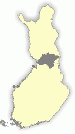
|File name=Map of Iijoki catchment.gif | |||
|Caption=Map of Iijoki catchment | |||
}} | }} | ||
{{Image_gallery_end}} | |||
{{Toggle button}} | |||
{{Toggle content start}} | |||
{{Case_study_subcatchment | {{Case_study_subcatchment | ||
|Subcatchment= | |Subcatchment= | ||
| Line 67: | Line 76: | ||
}} | }} | ||
{{Measures | {{Measures | ||
|Bank and bed modifications measure= | |Bank and bed modifications measure=Building submerged weir, Removal of old logs, Re-introducing spawning gravel, Habitat restoration, Removal of revetments | ||
|Floodplain / River corridor=Remeandering, Reconnection of drained river sections, Removal of embankments | |||
|Planform / Channel pattern=Adding sinuosity, | |||
|Other technical measure=Rehabilitation of water levels in nearby lakes | |||
|Floodplain / River corridor= | |Management interventions=fish stockings, Monitoring strategy, juridical processes | ||
|Planform / Channel pattern= | |||
|Other technical measure= | |||
|Management interventions= | |||
}} | }} | ||
{{Hydromorphological_quality_elements_header}} | {{Hydromorphological_quality_elements_header}} | ||
| Line 177: | Line 175: | ||
}} | }} | ||
{{End_table}} | {{End_table}} | ||
{{ | {{Biological quality elements header}} | ||
{{ | {{Biological quality element table row | ||
|Element= | |Element=Fish: Abundance | ||
|Monitored before=Yes | |||
|Monitored after=Yes | |||
|Qualitative monitoring=No | |||
|Quantitative monitoring=No | |||
|Control site used=No | |||
|Monitored before= | |Result=Improvement | ||
|Monitored after= | |||
|Qualitative monitoring= | |||
|Quantitative monitoring= | |||
|Control site used= | |||
|Result= | |||
}} | }} | ||
{{ | {{Biological quality element table row | ||
|Element= | |Element=Invertebrates | ||
|Monitored before=Yes | |||
|Monitored after=Yes | |||
|Qualitative monitoring=No | |||
|Monitored before= | |Quantitative monitoring=No | ||
|Control site used=No | |||
|Result=Inconclusive | |||
|Monitored after= | |||
|Qualitative monitoring= | |||
|Quantitative monitoring= | |||
|Control site used= | |||
|Result= | |||
}} | }} | ||
{{End_table}} | {{End_table}} | ||
{{Physico- | {{Physico-chemical quality elements header}} | ||
{{End_table}} | {{End_table}} | ||
{{Other_responses_header}} | {{Other_responses_header}} | ||
| Line 281: | Line 223: | ||
{{Monitoring_documents}} | {{Monitoring_documents}} | ||
{{Monitoring_documents_end}} | {{Monitoring_documents_end}} | ||
{{Additional_Documents}} | {{Additional_Documents}} | ||
{{Additional_Documents_end}} | {{Additional_Documents_end}} | ||
| Line 295: | Line 229: | ||
{{Supplementary_Information | {{Supplementary_Information | ||
|Information= | |Information= | ||
}} | }} | ||
{{Case_study_upload}} | {{Case_study_upload}} | ||
{{Toggle content end}} | |||
Latest revision as of 14:42, 2 January 2019
Location: 65° 19' 28.71" N, 25° 25' 40.83" E
Left click to look around in the map, and use the wheel of your mouse to zoom in and out.
Project overview
| Status | Complete |
|---|---|
| Project web site | http://www.ymparisto.fi/default.asp?node=5579&lan=fi |
| Themes | Fisheries, Habitat and biodiversity, Hydropower, Hydromorphology, Land use management - forestry |
| Country | Finland |
| Main contact forename | Timo |
| Main contact surname | Yrjänä |
| Main contact user ID | |
| Contact organisation | Centre for Economic Development, Transport and the Environment for North Ostrobothnia |
| Contact organisation web site | http://www.ymparisto.fi/default.asp?node=25563&lan=fi |
| Partner organisations | Metsähallitus (National Forestry Board) |
| This is a parent project encompassing the following projects |
Restoration of Kostonjoki River |
Project summary
Edit project overview to modify the project summary.
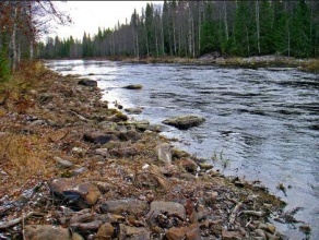
River Iijoki has been restored mainly because of altered river morphology caused by intensive forestry and timber floating. Besides the main channel of River Iijoki, also all tributaries of this large river area have been restored. The main channel of the river is mainly harnessed for hydro power production and also two tributaries are regulated.
Monitoring surveys and results
This case study hasn’t got any Monitoring survey and results, you can add some by editing the project overview.
Lessons learnt
This case study hasn’t got any lessons learnt, you can add some by editing the project overview.
Image gallery
|
Catchment and subcatchmentSelect a catchment/subcatchment
Catchment
Subcatchment
Site
Project background
Cost for project phases
Reasons for river restoration
Measures
MonitoringHydromorphological quality elements
Biological quality elements
Physico-chemical quality elements
Any other monitoring, e.g. social, economic
Monitoring documents
Additional documents and videos
Additional links and references
Supplementary InformationEdit Supplementary Information
| ||||||||||||||||||||||||||||||||||||||||||||||||||||||||||||||||||||||||||||||||||||||||||||||||||||||||||||||||||||||||||||||||||||||||||||||||||||||||||||||||||||||||||||||||||||||||||||||||||||||||||||||||||||||||||||||||||||||||||||||||||||||


