Case study:Černý potok stream restoration scheme: Difference between revisions
Jump to navigation
Jump to search
No edit summary |
No edit summary |
||
| (8 intermediate revisions by 5 users not shown) | |||
| Line 1: | Line 1: | ||
{{Case study status | {{Case study status | ||
|Approval status= | |Approval status=Approved | ||
}} | }} | ||
{{Location | {{Location | ||
|Location=50. | |Location=50.7287674, 13.895860900000002 | ||
}} | }} | ||
{{Project overview | {{Project overview | ||
| Line 17: | Line 17: | ||
|Multi-site=No | |Multi-site=No | ||
|Project picture=5692 1148013232744 1599979005 30374015 6263082 n.jpg | |Project picture=5692 1148013232744 1599979005 30374015 6263082 n.jpg | ||
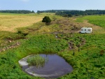
|Picture description= | |Picture description=Central part of the stream restoration | ||
|Project summary=Creation of ponds by partially filling up the deepened and straightened channel. | |||
}} | }} | ||
{{Image gallery}} | |||
{{Case study image | |||
|File name=P1040623.JPG | |||
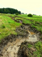
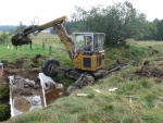
|Caption=excavation of the new channel | |||
}} | |||
{{Case study image | |||
|File name=P1040802.JPG | |||
|Caption=excavation site | |||
}} | |||
{{Case study image | |||
|File name=P1040608.JPG | |||
|Caption=filling up the small "dams" in the deepened channel | |||
}} | |||
{{Case study image | |||
|File name=P1050177.JPG | |||
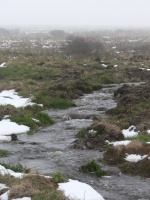
|Caption=winter higher flow | |||
}} | |||
{{Image gallery end}} | |||
{{Toggle button}} | |||
{{Toggle content start}} | |||
{{Case study subcatchment | {{Case study subcatchment | ||
|Subcatchment=Müglitz | |Subcatchment=Müglitz | ||
| Line 61: | Line 83: | ||
}} | }} | ||
{{Measures | {{Measures | ||
|Bank and bed modifications measure=construction of nearly completly new streambeds and directing water freely to the alluvial meadows | |Bank and bed modifications measure=construction of nearly completly new streambeds and directing water freely to the alluvial meadows | ||
|Floodplain / River corridor=Creation of | |Floodplain / River corridor=Creation of pond | ||
|Planform / Channel pattern= | |Planform / Channel pattern=Channel naturalisation, | ||
|Other technical measure=Recovering natural landscapes, | |Other technical measure=Recovering natural landscapes, | ||
|Management interventions=Management of vegetation, More natural water retention, | |Management interventions=Management of vegetation, More natural water retention, Monitoring strategy, | ||
|Wider stakeholder / citizen engagement=popularization of the project, | |Wider stakeholder / citizen engagement=popularization of the project, | ||
}} | }} | ||
{{Hydromorphological quality elements header}} | {{Hydromorphological quality elements header}} | ||
| Line 78: | Line 100: | ||
{{Monitoring documents}} | {{Monitoring documents}} | ||
{{Monitoring documents end}} | {{Monitoring documents end}} | ||
{{ | {{Additional Documents}} | ||
{{Case study | {{Case study documents | ||
|File name= | |File name=Hydrograph.jpg | ||
| | |Description=Hydrograph - restored versus deepened channel | ||
}} | }} | ||
{{Additional Documents end}} | {{Additional Documents end}} | ||
{{Additional links and references header}} | {{Additional links and references header}} | ||
{{Additional links and references footer}} | {{Additional links and references footer}} | ||
{{Supplementary Information}} | {{Supplementary Information}} | ||
{{Toggle content end}} | |||
Latest revision as of 17:11, 12 November 2018
Location: 50° 43' 43.56" N, 13° 53' 45.10" E
Left click to look around in the map, and use the wheel of your mouse to zoom in and out.
Project overview
| Status | Complete |
|---|---|
| Project web site | |
| Themes | Flood risk management, Habitat and biodiversity, Hydromorphology, Spatial planning, Water quality |
| Country | Czech Republic |
| Main contact forename | Rous |
| Main contact surname | Vít |
| Main contact user ID | User:VRous |
| Contact organisation | Nature Conservation Agency of the Czech Republic |
| Contact organisation web site | http://www.ochranaprirody.cz |
| Partner organisations | Terén Design Ltd - www.terendesign.cz, Grania Ltd - www.grania.cz |
| Parent multi-site project | |
| This is a parent project encompassing the following projects |
No |
Project summary
Edit project overview to modify the project summary.
Creation of ponds by partially filling up the deepened and straightened channel.
Monitoring surveys and results
This case study hasn’t got any Monitoring survey and results, you can add some by editing the project overview.
Lessons learnt
This case study hasn’t got any lessons learnt, you can add some by editing the project overview.
Image gallery
|
Catchment and subcatchmentSelect a catchment/subcatchment
Catchment
Subcatchment
Site
Project background
Cost for project phases
Reasons for river restoration
Measures
MonitoringHydromorphological quality elements
Biological quality elements
Physico-chemical quality elements
Any other monitoring, e.g. social, economic
Monitoring documents
Additional documents and videos
Additional links and references
Supplementary InformationEdit Supplementary Information
| ||||||||||||||||||||||||||||||||||||||||||||||||||||||||||||||||||||||||||||||||||||||||||||||||||||||||||||||||||||||||||||||||||||||||||||||||||||||||||||||||||||||||||||||||||||||||||||||


