Case study:Tall River: Difference between revisions
No edit summary |
No edit summary |
||
| (4 intermediate revisions by the same user not shown) | |||
| Line 11: | Line 11: | ||
|Main contact forename=Judith | |Main contact forename=Judith | ||
|Main contact surname=Bankhead | |Main contact surname=Bankhead | ||
|Contact organisation=Rivers Agency | |Contact organisation=Rivers Agency Northern Ireland (DARDNI) | ||
|Contact organisation url=www.dardni.gov.uk/index/rivers.htm | |Contact organisation url=www.dardni.gov.uk/index/rivers.htm | ||
|Multi-site=No | |Multi-site=No | ||
| Line 20: | Line 20: | ||
A repeat RCS carried out two years post works indicated an increase in emergent vegetation and macrophyte diversity. The bays are inundated at high flows, acting as a fish refuge, however due to siltation these may be becoming too shallow. Following the creation of stone cascades greater flow variation has been ovserved. The success of the bays appears to depend on the presence, or otherwise, of a structure deflecting water into them. | A repeat RCS carried out two years post works indicated an increase in emergent vegetation and macrophyte diversity. The bays are inundated at high flows, acting as a fish refuge, however due to siltation these may be becoming too shallow. Following the creation of stone cascades greater flow variation has been ovserved. The success of the bays appears to depend on the presence, or otherwise, of a structure deflecting water into them. | ||
If the project was to be carried out again more consideration should be given to the location of the bays within the overall flow regime or alternatively structures that would maintain flows into the bay should be included in the design. | If the project was to be carried out again more consideration should be given to the location of the bays within the overall flow regime or alternatively structures that would maintain flows into the bay should be included in the design. | ||
Plus, part of a wider scheme developing footpath access along the river. | |||
}} | }} | ||
{{Image gallery}} | {{Image gallery}} | ||
| Line 59: | Line 61: | ||
{{Measures | {{Measures | ||
|Bank and bed modifications measure=Creation of four bays on right hand bank | |Bank and bed modifications measure=Creation of four bays on right hand bank | ||
|Floodplain / River corridor=Connection to wider floodplain, | |Floodplain / River corridor=Connection to wider floodplain, | ||
|Planform / Channel pattern=Creation of | |Planform / Channel pattern=Creation of backwater, | ||
|Social measures= | |Social measures=Improved public access, | ||
}} | }} | ||
{{Hydromorphological quality elements header}} | {{Hydromorphological quality elements header}} | ||
Latest revision as of 12:13, 6 June 2017
Project overview
| Status | Complete |
|---|---|
| Project web site | |
| Themes | Fisheries, Flood risk management, Habitat and biodiversity |
| Country | Northern Ireland |
| Main contact forename | Judith |
| Main contact surname | Bankhead |
| Main contact user ID | |
| Contact organisation | Rivers Agency Northern Ireland (DARDNI) |
| Contact organisation web site | http://www.dardni.gov.uk/index/rivers.htm |
| Partner organisations | |
| Parent multi-site project | |
| This is a parent project encompassing the following projects |
No |
Project summary
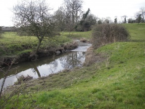
The Tall River is a main tributary of the River Blackwater, flowing through Co. Armagh. It is a slow flowing, low energy river within an agricultural catchment. The river had been subject to an arterial drainage scheme in the 1960s, which deepened and widened the river as well as disconnecting it from its floodplain. The 1.2km Tall River scheme was the first project within Northern Ireland to address the specific need to enhance the riverine environment, rather than being attached to a larger flood prevention scheme. Works could only be carried out in-channel and on the National Trust owned right bank due to landowner restrictions.
The aim of the protect was to create shallow slack-water habitat through the creation of bays. These would provide shelter for fish fry and invertebrates during high flows and aimed to increase macrophyte diversity within the reach. Stone cascades were also installed to direct flow away from potentially erodable banks.
A repeat RCS carried out two years post works indicated an increase in emergent vegetation and macrophyte diversity. The bays are inundated at high flows, acting as a fish refuge, however due to siltation these may be becoming too shallow. Following the creation of stone cascades greater flow variation has been ovserved. The success of the bays appears to depend on the presence, or otherwise, of a structure deflecting water into them.
If the project was to be carried out again more consideration should be given to the location of the bays within the overall flow regime or alternatively structures that would maintain flows into the bay should be included in the design.
Plus, part of a wider scheme developing footpath access along the river.
Monitoring surveys and results
Lessons learnt
Image gallery
|
Catchment and subcatchment
Site
Project background
Cost for project phases
Supplementary funding informationInformation about cost of scheme not available
Reasons for river restoration
Measures
MonitoringHydromorphological quality elements
Biological quality elements
Physico-chemical quality elements
Any other monitoring, e.g. social, economic
Monitoring documents
Additional documents and videos
Additional links and references
Supplementary InformationEdit Supplementary Information
| ||||||||||||||||||||||||||||||||||||||||||||||||||||||||||||||||||||||||||||||||||||||||||||||||||||||||||||||||||||||||||||||||||||||||||||||||||||||||||||||||||||||||||||||||||||||||||||||||||


