Case study:Flood detention basin (HRB) Mengede: Difference between revisions
No edit summary |
No edit summary |
||
| Line 90: | Line 90: | ||
|Floodplain / River corridor=Increase water retention area, Connection to wider floodplain, Wetland habitat | |Floodplain / River corridor=Increase water retention area, Connection to wider floodplain, Wetland habitat | ||
|Planform / Channel pattern=Channel naturalisation, Improvement of channel morphology, Enabling dynamics, Creation of new meandering channel, | |Planform / Channel pattern=Channel naturalisation, Improvement of channel morphology, Enabling dynamics, Creation of new meandering channel, | ||
|Social measures= | |Social measures=Community involvement, | ||
}} | }} | ||
{{Hydromorphological quality elements header}} | {{Hydromorphological quality elements header}} | ||
Revision as of 14:39, 5 June 2017
Project overview
| Status | Complete |
|---|---|
| Project web site | |
| Themes | Habitat and biodiversity, Hydromorphology |
| Country | Germany |
| Main contact forename | Mechthild |
| Main contact surname | Semrau |
| Main contact user ID | User:EGLV |
| Contact organisation | Emschergenossenschaft |
| Contact organisation web site | http://eglv.de |
| Partner organisations | |
| Parent multi-site project | |
| This is a parent project encompassing the following projects |
No |
Project summary
Part of the integrated river basin management for the Emscher Region (865 km2, 2.700 inhabitants/ km2) is the revitalization of the river Emscher and its tributaries. Due to industrialization the waterbodies were systematically developed as open wastewater sewers in the beginning of the 20th century. Economic and technical alternatives such as closed sewer systems could not be implemented due to constant subsidence caused by coal mining.
Momentarily, the river system is being restructured in order to enable the Emscher to once again be a fully functioning, continuous water-based ecosystem with typical topology and vegetation.
An ecological concept based on the assumption of a non-interrupted river as a connection from the source to the mouth has been developed.
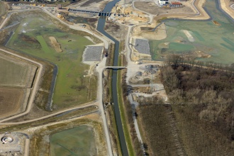
Studies on the feasibility of restructuring the Emscher show, that due to coal mining, industrial impacts and population changes the “original” conditions can never be reached again. It will not be possible to return the Emscher to its original, meandering state. Therefore, the reference conditions are no direct goals for the river restoration, but they give orientation in the planning procedure. One of the first hot spots that has been put into practice is the HRB Ickern-Mengede. The HRB comprises an area of 30 ha, where a typical lowland river with natural substrats, features and vegetation can be formed. A varied mosaic of biotopes, which are typical for floodplains (alder floodplain forest, sedge, typha and phragmites reed, floodgrass and potamogeton) is expected to develop. Most importantly, the basin can hold a volume of 1,1 km3 to protect the downstream riparian communities. After the ecological restoration of the Emscher basin, it won't be able to discharge floods as quickly, hence the upstream flood protection must be enhanced. Two million m3 of native soil had to be excavated. 450 000 m3 of this have been used to build a landscape monument between the basin and the close highway, thereby reducing noise pollution for the inhabitants of the basin and the close area. It has also been made accessible for the public as a lookout.
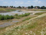
The river Emscher will be integrated into the basin, hence even smaller floods will reach the floodplain that has been created. Parts of the basin will be flooded about 80 days a year. Since the bottom of the HRB is uneven, parts of it will constantly be a body of standing water, whereas some elevated parts will be islands even during high floods. This diversity of topologic forms will lead to a great diversity in habitats - and therefore species.
As of now, the basin is still divided into three smaller parts by the dyked Emscher, because it needs to be separated from the wastewater which the Emscher is still carrying. Only during high floods diluted wastewater will run over the dykes to flood the basins. Once the wastewater is fully removed from the river, there will be a slight remodelling of the basins (removal of the dykes), thus creating the possibility for the river to mold its own body and have access to the floodplain.
Public participation process during the planning phase, 2006 a public workshop was organised by the EG on the design aspects of the construction (e.g. bike trails).
Monitoring surveys and results
Lessons learnt
Image gallery
|
Catchment and subcatchmentSelect a catchment/subcatchment
Catchment
Subcatchment
Other case studies in this subcatchment: Upper Emscher
Site
Project background
Cost for project phases
Reasons for river restoration
Measures
MonitoringHydromorphological quality elements
Biological quality elements
Physico-chemical quality elements
Any other monitoring, e.g. social, economic
Monitoring documents
Additional documents and videos
Additional links and references
Supplementary InformationEdit Supplementary Information
| |||||||||||||||||||||||||||||||||||||||||||||||||||||||||||||||||||||||||||||||||||||||||||||||||||||||||||||||||||||||||||||||||||||||||||||||||||||||||||||||||||||||||||||||||||||||||||||||||||||||||||||||||||||||||||||||||||||||||||||||||||||||||||||||||||||||||||


