Case study:The Ciobarciu Wetland Project: Difference between revisions
No edit summary |
No edit summary |
||
| (4 intermediate revisions by 3 users not shown) | |||
| Line 22: | Line 22: | ||
The Ciobarciu Wetland was created in October 2006 after first flooding of this area. | The Ciobarciu Wetland was created in October 2006 after first flooding of this area. | ||
}} | }} | ||
{{Image gallery}} | |||
{{Case study image | |||
|File name=Ciobarciu area past situation.jpg | |||
|Caption=Ciobarciu area - before restoration | |||
}} | |||
{{Case study image | |||
|File name=Ciobarciu wetland during restoration.JPG | |||
|Caption=Ciobarciu area - during restoration | |||
}} | |||
{{Case study image | |||
|File name=Ciobarciu area after restoration (1).JPG | |||
|Caption=Ciobarciu area - after restoration (1) | |||
}} | |||
{{Case study image | |||
|File name=Ciobarciu Wetland after restoration (2).JPG | |||
|Caption=Ciobarciu area - after restoration (2) | |||
}} | |||
{{Image_gallery_end}} | |||
{{Toggle button}} | |||
{{Toggle content start}} | |||
{{Case_study_subcatchment | {{Case_study_subcatchment | ||
|Subcatchment= | |Subcatchment= | ||
| Line 45: | Line 66: | ||
|Avrg channel gradient=0.001 | |Avrg channel gradient=0.001 | ||
}} | }} | ||
{{ | {{Project background | ||
|Reach length directly affected= | |Reach length directly affected=5,500 m | ||
|Project started=2003/03/01 | |||
|Works started=2006/06/01 | |||
|Works completed=2006/10/01 | |||
|Project started= | |Total cost category=100 - 500 k€ | ||
|Total1 cost=388 k€ | |||
|Works started= | |Funding sources=The Netherlands Government programme MATRA; Co-financing Ministry of Environment and Water Management | ||
|Investigation and design Lead organisation=Regional water authority Hunze & Aa’s www.hunzeenaas.nl | |||
|Works completed= | |Investigation and design Other contact forename=Albert | ||
|Investigation and design Other contact surname=Remmelzwaal | |||
|Stakeholder engagement Lead organisation=Prut - Barlad River Basin Authority | |||
|Stakeholder engagement Other contact forename=Dan | |||
|Total cost category= | |Stakeholder engagement Other contact surname=Badarau | ||
|Works and supervision Lead organisation=Prut - Barlad River Basin Authority | |||
|Total1 cost= | |Works and supervision Other contact forename=Anca | ||
|Works and supervision Other contact surname=Savin | |||
|Funding sources= | |Monitoring Lead organisation=Prut - Barlad River Basin Authority | ||
MATRA; Co-financing Ministry of Environment and Water Management | |||
|Investigation and design Lead organisation= | |||
|Investigation and design Other contact forename= | |||
|Investigation and design Other contact surname= | |||
|Stakeholder engagement Lead organisation= | |||
|Stakeholder engagement Other contact forename= | |||
|Stakeholder engagement Other contact surname= | |||
|Works and supervision Lead organisation= | |||
|Works and supervision Other contact forename= | |||
|Works and supervision Other contact surname= | |||
|Monitoring Lead organisation= | |||
}} | }} | ||
{{Motivations | {{Motivations | ||
| Line 133: | Line 100: | ||
}} | }} | ||
{{Measures | {{Measures | ||
|Floodplain / River corridor=Creation of wetland, Removal of embankments, | |||
|Planform / Channel pattern=Re-instatement of old course | |||
|Other technical measure=Improvement of natural flows, | |||
|Social measures=Improved public access, Land purchase, | |||
|Floodplain / River corridor= | |Wider stakeholder / citizen engagement=Consultation | ||
|Planform / Channel pattern= | |||
|Other technical measure= | |||
|Social measures= | |||
|Wider stakeholder / citizen engagement= | |||
}} | }} | ||
{{Hydromorphological_quality_elements_header}} | {{Hydromorphological_quality_elements_header}} | ||
| Line 203: | Line 159: | ||
}} | }} | ||
{{Monitoring_documents_end}} | {{Monitoring_documents_end}} | ||
{{Additional_Documents}} | {{Additional_Documents}} | ||
{{Additional_Documents_end}} | {{Additional_Documents_end}} | ||
| Line 235: | Line 173: | ||
{{Supplementary_Information | {{Supplementary_Information | ||
|Information= | |Information= | ||
}} | }} | ||
{{Case_study_upload}} | {{Case_study_upload}} | ||
{{Toggle content end}} | |||
Latest revision as of 12:04, 5 June 2017
Project overview
| Status | Complete |
|---|---|
| Project web site | http://www.ciobarciu.ro |
| Themes | Habitat and biodiversity |
| Country | Romania |
| Main contact forename | Anca |
| Main contact surname | Savin |
| Main contact user ID | |
| Contact organisation | Prut - Barlad River Basin Authority |
| Contact organisation web site | http://www.apeprut.ro |
| Partner organisations | Institute for Inland Water Management RIZA, Regional Water Board Hunze&Aa's, Het Drentse Landschap (NGO for nature management) |
| Parent multi-site project | |
| This is a parent project encompassing the following projects |
No |
Project summary
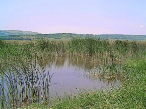
The Ciobarciu Wetland Project is an ecological rehabilitation project in the valley of the river Prut.
In order to prevent flooding and to extend agricultural surfaces, the common floodplain of Prut and Jijia was embanked. Jijia river course was deviated by digging a channel to the Prut at Chiperesti. The last 56 km of the Jijia river, which is parallel to the Prut, has been cut-off (it is now known as the Old Jijia). The Old Jijia can be supplied with water from the Jijia by the hydrotechnical knot at Chiperesti when needed. Otherwise, the Old Jijia is only supplied from its own river basin by four small tributaries with intermittent flow.
The Ciobarciu Wetland was created in October 2006 after first flooding of this area.
Monitoring surveys and results
Lessons learnt
Image gallery
|
Catchment and subcatchmentSelect a catchment/subcatchment
Catchment
Subcatchment
Other case studies in this subcatchment: Ecological Restoration of Mata-Radeanu Complex, Ecological Restoration of Natural Lake Pochina, Ecological Restoration of Vlascuta Lake
Site
Project background
Cost for project phases
Reasons for river restoration
Measures
MonitoringHydromorphological quality elements
Biological quality elements
Physico-chemical quality elements
Any other monitoring, e.g. social, economic
Monitoring documents
Additional documents and videos
Additional links and references
Supplementary InformationEdit Supplementary Information
| ||||||||||||||||||||||||||||||||||||||||||||||||||||||||||||||||||||||||||||||||||||||||||||||||||||||||||||||||||||||||||||||||||||||||||||||||||||||||||||||||||||||||||||||||||||||||||||||||||||||||||||||||||||||||||


