Case study:Burn of Mosset, Forres: Difference between revisions
No edit summary |
No edit summary |
||
| (12 intermediate revisions by 4 users not shown) | |||
| Line 1: | Line 1: | ||
{{Case study status | {{Case study status | ||
|Approval status= | |Approval status=Approved | ||
}} | }} | ||
{{Location | {{Location | ||
| Line 9: | Line 9: | ||
|Themes=Fisheries, Flood risk management, Habitat and biodiversity, Hydromorphology | |Themes=Fisheries, Flood risk management, Habitat and biodiversity, Hydromorphology | ||
|Country=Scotland | |Country=Scotland | ||
|Main contact forename= | |Main contact forename=Paul | ||
|Main contact surname= | |Main contact surname=Winfield | ||
|Contact organisation=Royal HaskoningDHV | |Contact organisation=Royal HaskoningDHV | ||
|Multi-site=No | |Multi-site=No | ||
| Line 17: | Line 17: | ||
|Project summary=The Burn of Mosset is a small gravel bed stream draining an area of 49km2. A Tributary of the River Findhorn, it flows north through the town of Forres before entering Findhorn bay. The town of Forres has a long history of flooding from the burn, with six flood events causing serious damage to property or disruption in the last fifty years. | |Project summary=The Burn of Mosset is a small gravel bed stream draining an area of 49km2. A Tributary of the River Findhorn, it flows north through the town of Forres before entering Findhorn bay. The town of Forres has a long history of flooding from the burn, with six flood events causing serious damage to property or disruption in the last fifty years. | ||
The new Flood Alleviation Scheme (FAS) took two years to complete. It included the construction of an earth-filled embankment dam designed to allow for discharges up to 8.5 m3/s to flow through Forres, with excess floodwater temporarily stored behind the dam. | The new Flood Alleviation Scheme (FAS) took two years to complete. It included the construction of an earth-filled embankment dam designed to allow for discharges up to 8.5 m3/s to flow through Forres, with excess floodwater temporarily stored behind the dam. | ||
In addition to this, the upstream storage area has been designed to create an extensive natural sediment accretion zone (for sand, gravel and large wood). This will reduce the risk of sediment or other debris blocking the dam control structure. The scheme also aimed to create a mosaic of river and floodplain habitats, by working with natural processes to develop a multi-thread (anabranched) system. | In addition to this, the upstream storage area has been designed to create an extensive natural sediment accretion zone (for sand, gravel and large wood). This will reduce the risk of sediment or other debris blocking the dam control structure. The scheme also aimed to create a mosaic of river and floodplain habitats, by working with natural processes to develop a multi-thread (anabranched) system. | ||
This was achieved by breaching the existing embanked channel which ran around a field boundary at two points, allowing flow to spill out across the open field, before re-joining the original channel just upstream of the dam. Tress were planted across the site to create a wet woodland habitat. | This was achieved by breaching the existing embanked channel which ran around a field boundary at two points, allowing flow to spill out across the open field, before re-joining the original channel just upstream of the dam. Tress were planted across the site to create a wet woodland habitat. | ||
In 2010 the | This project is part of the UK River Restoration Center's manual of river restoration techniques (update due to be published in late 2013). | ||
|Monitoring surveys and results=Approximately one year after the banks were breached in September 2009, the channel experienced an estimated 30m3/s flood flow (of the order of a 1 in 10 year event). The stone protection at the upstream breach was partially washed out, as anticipated. The breach enlarged such that the majority of the flow was diverted along the new route after the flow subsided. The result was rapid development of river features including the formation of an outwash fan. Some ecological degradation has occurred in the short term as the old channel is now dry except during very high flow events. | |||
Small on-going adaptive management is predicted to be necessary in the short to medium term until this modified river system becomes better established. | |||
|Lessons learn=Overall this scheme illustrates what can be achieved when working with natural sediment transport processes in flood storage zones. In 2010, the Saltire Society of Scotland in association with the Institution of Civil Engineers awarded the Forres Flood Alleviation Scheme its 'Environmental Sustainable Construction' commendation. | |||
}} | }} | ||
{{Image gallery}} | |||
{{Case study image | |||
|File name=P5130077.JPG | |||
|Caption=Chapelton Dam control structure (2013) | |||
}} | |||
{{Case study image | |||
|File name=P5130108.JPG | |||
|Caption=The Burn management works (2013) | |||
}} | |||
{{Case study image | |||
|File name=P5130109.JPG | |||
|Caption=Woody material and sediment is now effectively being stored in the floodplain | |||
}} | |||
{{Case study image | |||
|File name=P5130062.JPG | |||
|Caption=Chapelton Dam (2013) | |||
}} | |||
{{Case study image | |||
|File name=P5130064.JPG | |||
|Caption=Chapelton Dam flood storage area (2013) | |||
}} | |||
{{Image gallery end}} | |||
{{Toggle button}} | |||
{{Toggle content start}} | |||
{{Case study subcatchment | {{Case study subcatchment | ||
|Subcatchment=Burn of Mosset | |Subcatchment=Burn of Mosset | ||
| Line 49: | Line 78: | ||
}} | }} | ||
{{Measures | {{Measures | ||
|Bank and bed modifications measure=Create breaches in the bank, | |Bank and bed modifications measure=Create breaches in the bank, | ||
|Floodplain / River corridor=Floodplain reconnection, Riparian | |Floodplain / River corridor=Floodplain reconnection, Riparian planting, | ||
|Planform / Channel pattern= | |Planform / Channel pattern=Channel naturalisation, | ||
}} | }} | ||
{{Hydromorphological quality elements header}} | {{Hydromorphological quality elements header}} | ||
| Line 63: | Line 92: | ||
{{Monitoring documents}} | {{Monitoring documents}} | ||
{{Monitoring documents end}} | {{Monitoring documents end}} | ||
{{Additional Documents}} | {{Additional Documents}} | ||
{{Additional Documents end}} | {{Additional Documents end}} | ||
{{Additional links and references header}} | {{Additional links and references header}} | ||
{{Additional links and references | |||
|Link=www.royalhaskoning.co.uk/en-gb/Publication/Documents/projects/forres-flood-alleviation-scheme.pdf | |||
|Description=Royal Haskoning- Forres Flood Alleviation Scheme | |||
}} | |||
{{Additional links and references | |||
|Link=www.moray.gov.uk/downloads/file86456.pdf | |||
|Description=Moray council- Forres FAS | |||
}} | |||
{{Additional links and references footer}} | {{Additional links and references footer}} | ||
{{Supplementary Information}} | {{Supplementary Information}} | ||
{{Toggle content end}} | |||
Latest revision as of 10:00, 5 June 2017
Project overview
| Status | Complete |
|---|---|
| Project web site | |
| Themes | Fisheries, Flood risk management, Habitat and biodiversity, Hydromorphology |
| Country | Scotland |
| Main contact forename | Paul |
| Main contact surname | Winfield |
| Main contact user ID | |
| Contact organisation | Royal HaskoningDHV |
| Contact organisation web site | |
| Partner organisations | |
| Parent multi-site project | |
| This is a parent project encompassing the following projects |
No |
Project summary
The Burn of Mosset is a small gravel bed stream draining an area of 49km2. A Tributary of the River Findhorn, it flows north through the town of Forres before entering Findhorn bay. The town of Forres has a long history of flooding from the burn, with six flood events causing serious damage to property or disruption in the last fifty years.
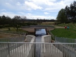
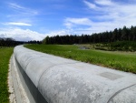
The new Flood Alleviation Scheme (FAS) took two years to complete. It included the construction of an earth-filled embankment dam designed to allow for discharges up to 8.5 m3/s to flow through Forres, with excess floodwater temporarily stored behind the dam.
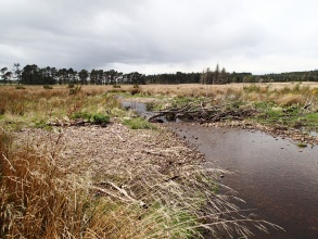
In addition to this, the upstream storage area has been designed to create an extensive natural sediment accretion zone (for sand, gravel and large wood). This will reduce the risk of sediment or other debris blocking the dam control structure. The scheme also aimed to create a mosaic of river and floodplain habitats, by working with natural processes to develop a multi-thread (anabranched) system. This was achieved by breaching the existing embanked channel which ran around a field boundary at two points, allowing flow to spill out across the open field, before re-joining the original channel just upstream of the dam. Tress were planted across the site to create a wet woodland habitat.
This project is part of the UK River Restoration Center's manual of river restoration techniques (update due to be published in late 2013).
Monitoring surveys and results
Approximately one year after the banks were breached in September 2009, the channel experienced an estimated 30m3/s flood flow (of the order of a 1 in 10 year event). The stone protection at the upstream breach was partially washed out, as anticipated. The breach enlarged such that the majority of the flow was diverted along the new route after the flow subsided. The result was rapid development of river features including the formation of an outwash fan. Some ecological degradation has occurred in the short term as the old channel is now dry except during very high flow events.
Small on-going adaptive management is predicted to be necessary in the short to medium term until this modified river system becomes better established.
Lessons learnt
Overall this scheme illustrates what can be achieved when working with natural sediment transport processes in flood storage zones. In 2010, the Saltire Society of Scotland in association with the Institution of Civil Engineers awarded the Forres Flood Alleviation Scheme its 'Environmental Sustainable Construction' commendation.
Image gallery
|
Catchment and subcatchmentSelect a catchment/subcatchment
Catchment
Subcatchment
Site
Project background
Cost for project phases
Reasons for river restoration
Measures
MonitoringHydromorphological quality elements
Biological quality elements
Physico-chemical quality elements
Any other monitoring, e.g. social, economic
Monitoring documents
Additional documents and videos
Additional links and references
Supplementary InformationEdit Supplementary Information
| ||||||||||||||||||||||||||||||||||||||||||||||||||||||||||||||||||||||||||||||||||||||||||||||||||||||||||||||||||||||||||||||||||||||||||||||||||||||||||||||||||||||||||||||||||||||||||||||||||||||||||||


