Case study:Lugg & Arrow, Radnorshire: Difference between revisions
Eldridge123 (talk | contribs) No edit summary |
No edit summary |
||
| (4 intermediate revisions by one other user not shown) | |||
| Line 1: | Line 1: | ||
{{Case study status | {{Case study status | ||
|Approval status= | |Approval status=Approved | ||
}} | }} | ||
{{Location | {{Location | ||
| Line 39: | Line 39: | ||
{{Case study subcatchment}} | {{Case study subcatchment}} | ||
{{Site}} | {{Site}} | ||
{{Project background}} | {{Project background | ||
{{Motivations}} | |Project started=2006/06/01 | ||
{{Measures}} | |Project completed=2008/06/01 | ||
}} | |||
{{Motivations | |||
|Specific mitigation=Habitat degradation, Barriers to fish migration, Erosion of banks | |||
}} | |||
{{Measures | |||
|Bank and bed modifications measure=Removal of fish barriers, Fencing, | |||
|Management interventions=Supporting local fisheries through marketing initiatives | |||
}} | |||
{{Hydromorphological quality elements header}} | {{Hydromorphological quality elements header}} | ||
{{End table}} | {{End table}} | ||
Latest revision as of 09:15, 29 September 2014
Project overview
| Status | Complete |
|---|---|
| Project web site | http://www.wyeuskfoundation.org/projects/luggandarrowrad.php |
| Themes | Economic aspects, Fisheries, Habitat and biodiversity |
| Country | Wales |
| Main contact forename | Stephen |
| Main contact surname | Marsh-Smith |
| Main contact user ID | |
| Contact organisation | Wye & Usk Foundation |
| Contact organisation web site | http://www.wyeuskfoundation.org/ |
| Partner organisations | |
| Parent multi-site project | |
| This is a parent project encompassing the following projects |
No |
Project summary
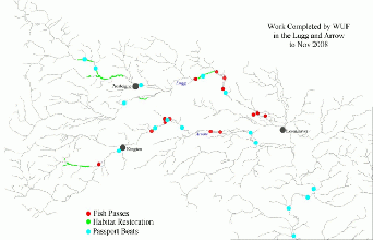
The upper most part of the rivers Lugg and Arrow rise in east Wales, before flowing through the border towns of Presteigne and Kington. At this point, both are quite substantial rivers and since these upper reaches qualify for funding from East Wales European Regional Development Funds, and are in urgent need of restoration, we designed a project focussing on habitat restoration and fisheries development. Building on work delivered by the Foundation and its partners within the Leader + Projects downstream in Herefordshire (which established fish access within the lower Lugg and Arrow), the project's aims are: restoring the riparian habitat so that fish populations become self sustaining and encouraging the diversification of rural businesses to meet the growing demand for 'wild' fishing, thereby enhancing the rural economy of Radnorshire.
This will be achieved by implementing the following measures:
• A comprehensive survey of the environmental/ecological issues within the Lugg and Arrow catchments.
• Targeted restoration of 25km of riparian habitat, directly ourselves and in association with landowners and other conservation organisations such as the Radnorshire Wildlife Trust.
• Restoration of riparian habitat, using our own workforce and in association with landowners and other conservation organisations such as the Radnorshire Wildlife Trust.
• Restoration of fish access especially for brown trout within the sub catchment by removal of barriers.
• Supporting local fisheries through marketing initiatives (The Passport) and increasing business for local accommodation providers, pubs etc. Work commenced on the Gladestry Brook, an important tributary of the Arrow, where coppicing and fencing was completed on 3.5km of river. Other sites completed during the project included the Lugg at Pilleth, Dolly Green, Litton, Rock Bridge and Achill, the Arrow at Wernol and Upper Hergest, the Cascob Brook and the Builth Road Dulas. Most encouraging of all was the response from landowners, who realise the rationale behind the work and the undoubted benefits that accrue.
Monitoring surveys and results
Lessons learnt
Image gallery
|
Catchment and subcatchment
Site
Project background
Cost for project phases
Reasons for river restoration
Measures
MonitoringHydromorphological quality elements
Biological quality elements
Physico-chemical quality elements
Any other monitoring, e.g. social, economic
Monitoring documents
Additional documents and videos
Additional links and references
Supplementary InformationEdit Supplementary Information
| ||||||||||||||||||||||||||||||||||||||||||||||||||||||||||||||||||||||||||||||||||||||||||||||||||||||||||||||||||||||||||||||||||||||||||||||||||||||||||||||||||||||||||||||||||

