Case study:Built Kjøsnesbekken in the river Stjørdalselva: Difference between revisions
No edit summary |
No edit summary |
||
| (8 intermediate revisions by one other user not shown) | |||
| Line 1: | Line 1: | ||
{{Case study status | {{Case study status | ||
|Approval status= | |Approval status=Approved | ||
}} | }} | ||
{{Location | {{Location | ||
|Location=63.4601391, 11. | |Location=63.4601391, 11.1931992 | ||
}} | }} | ||
{{Project overview | {{Project overview | ||
| Line 26: | Line 26: | ||
The miniature river is constructed in a way that ensures that there will always be a minimum of running water. Discharge and water temperature is monitored in real-time. Along with annual biological inquires this will provide useful surveillance data that can be useful in similar projects. | The miniature river is constructed in a way that ensures that there will always be a minimum of running water. Discharge and water temperature is monitored in real-time. Along with annual biological inquires this will provide useful surveillance data that can be useful in similar projects. | ||
|Monitoring surveys and results=Water flow and temperature is logged every hour | |Monitoring surveys and results=Water flow and temperature is logged every hour | ||
Benthos and fish will be monitored yearly by NIVA | Benthos and fish will be monitored yearly by NIVA. | ||
The first salmon fry was observed two days after the channel was opened. | |||
One month after there were fish in the whole side channel: A. salmon, brown trout and flounder. There were three cohorts of A. salmon observed: 1+, 2+ & 3+. | |||
}} | }} | ||
{{Image gallery}} | {{Image gallery}} | ||
{{Case study image | |||
|File name=Arne photo6 juncion creek and main river.JPG | |||
|Caption=Creek and main river (photo: Arne Jørgen) | |||
}} | |||
{{Case study image | |||
|File name=Arne photo5 largest pond.JPG | |||
|Caption=Largest pond on the brook (photo: Arne Jørgen) | |||
}} | |||
{{Case study image | |||
|File name=Arne photo4.JPG | |||
|Caption=Added wood material (photo: arne Jørgen) | |||
}} | |||
{{Image gallery end}} | {{Image gallery end}} | ||
{{Toggle button}} | {{Toggle button}} | ||
{{Toggle content start}} | {{Toggle content start}} | ||
{{Case study subcatchment}} | {{Case study subcatchment}} | ||
{{Site}} | {{Site | ||
{{Project background}} | |Name=Kjøsnesbekken in the river Stjørdalselva | ||
{{Motivations}} | |WFD water body code=124.666 | ||
|Pre-project morphology=Dry land, Old river bed | |||
|Heavily modified water body=Yes | |||
|Protected species present=No | |||
|Invasive species present=No | |||
|Species=Brown trout (Salmo trutta), Atlantic salmon (Salmo salar), | |||
|Dominant substrate=Gravel, Bedrock, Clay, | |||
|Average bankfull channel width category=2 - 5 m | |||
|Average bankfull channel depth category=Less than 0.5 m | |||
|Mean discharge category=100 - 1000 m³/s | |||
|Average channel gradient category=0.01 - 0.1 | |||
}} | |||
{{Project background | |||
|Reach length directly affected=700 | |||
|Project started=2012/01/01 | |||
|Works completed=2013/07/01 | |||
|Total cost category=more than 10000 k€ | |||
|Total1 cost=100 | |||
|Monitoring Other contact forename=NIVA | |||
}} | |||
{{Motivations | |||
|Specific mitigation=Loss of suitable habitat and biodiversity | |||
|Biological quality elements=fish, invertebrates | |||
}} | |||
{{Measures}} | {{Measures}} | ||
{{Hydromorphological quality elements header}} | {{Hydromorphological quality elements header}} | ||
| Line 48: | Line 86: | ||
{{Monitoring documents end}} | {{Monitoring documents end}} | ||
{{Additional Documents}} | {{Additional Documents}} | ||
{{Case study documents | |||
|File name=River Arne sketch.pdf | |||
|Description=Leght profile of the brook (Arne Jørgen) | |||
}} | |||
{{Case study documents | |||
|File name=River Arne sketch lenght profile.pdf | |||
|Description=Leght profile 2 of the brook (Arne Jørgen) | |||
}} | |||
{{Additional Documents end}} | {{Additional Documents end}} | ||
{{Additional links and references header}} | {{Additional links and references header}} | ||
Latest revision as of 16:57, 20 September 2013
Project overview
| Status | Complete |
|---|---|
| Project web site | |
| Themes | Fisheries, Habitat and biodiversity, Hydropower, Hydromorphology, Monitoring |
| Country | Norway |
| Main contact forename | Arne |
| Main contact surname | Jørgen and Kjøsnes |
| Main contact user ID | User:Kasvio |
| Contact organisation | NVE (Norwegian Water Resources and Energy Directorate) |
| Contact organisation web site | http://www.nve.no/en/ |
| Partner organisations | |
| Parent multi-site project | |
| This is a parent project encompassing the following projects |
No |
Project summary
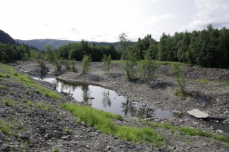
NVE constructed a complete new river side channel in an old river course next to the river Stjørdalselva in Norway. A unique collaboration between NVEs civil engineers, biologists and construction workers resulted in a 700m long and 2-5m wide miniature river containing all necessary habitats for salmonid fish.
It was built to compensate for the loss of suitable habitats in the main river due to human impacts such as railroad construction, hydropower regulation, removal of gravel from river bed, road building, flood protection work etc. Detailed planning with accurate calculations of slope, size of weirs, length of ponds, suitable water velocity on spawning grounds and use of correct substrate were done to ensure the new river could host fish of all cohorts.
Depth varies between 0,2 to 0,5m in the more rapid parts downstream the weirs. In the three resting ponds there are areas as deep as 1,5 m where fish can take shelter during periods of low water flows. Water flow varies between 150 – 800 l/sec depending on the flow in the main river. The inlet to the miniature river is through a 36 m long pipe with a diameter of 0,8m and the slope in the brook is 1:350m (3 ‰).
The use of riparian vegetation, roots with rootwad and large woody debris contributes with food and shelter for fish and also makes the area look very natural and untouched. The miniature river is constructed in a way that ensures that there will always be a minimum of running water. Discharge and water temperature is monitored in real-time. Along with annual biological inquires this will provide useful surveillance data that can be useful in similar projects.
Monitoring surveys and results
Water flow and temperature is logged every hour
Benthos and fish will be monitored yearly by NIVA.
The first salmon fry was observed two days after the channel was opened.
One month after there were fish in the whole side channel: A. salmon, brown trout and flounder. There were three cohorts of A. salmon observed: 1+, 2+ & 3+.
Lessons learnt
Image gallery
|
Catchment and subcatchment
Site
Project background
Cost for project phases
Reasons for river restoration
Measures
MonitoringHydromorphological quality elements
Biological quality elements
Physico-chemical quality elements
Any other monitoring, e.g. social, economic
Monitoring documents
Additional documents and videos
Additional links and references
Supplementary InformationEdit Supplementary Information
| ||||||||||||||||||||||||||||||||||||||||||||||||||||||||||||||||||||||||||||||||||||||||||||||||||||||||||||||||||||||||||||||||||||||||||||||||||||||||||||||||||||||||||||||||||


